Apeadero facts for kids
Quick facts for kids
Apeadero
|
|
|---|---|
|
Barrio
|
|

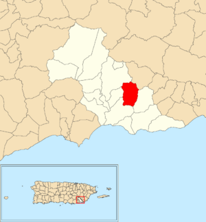
Location of Apeadero within the municipality of Patillas shown in red
|
|
| Commonwealth | |
| Municipality | |
| Area | |
| • Total | 2.29 sq mi (5.9 km2) |
| • Land | 2.29 sq mi (5.9 km2) |
| • Water | 0 sq mi (0 km2) |
| Elevation | 509 ft (155 m) |
| Population
(2010)
|
|
| • Total | 699 |
| • Density | 305.2/sq mi (117.8/km2) |
| Source: 2010 Census | |
| Time zone | UTC−4 (AST) |
Apeadero is a small community, also called a barrio, located in the town of Patillas, Puerto Rico. In 2010, about 699 people lived there. It's a part of the beautiful island of Puerto Rico, which is a commonwealth of the United States.
Apeadero's History
Puerto Rico used to be a territory of Spain. After the Spanish–American War in 1898, Spain gave Puerto Rico to the United States. This happened because of a special agreement called the Treaty of Paris of 1898. Since then, Puerto Rico has been an unincorporated territory of the United States.
In 1899, the United States government counted all the people in Puerto Rico. They found that Apeadero and a nearby community called Mamey had a combined population of 1,249 people.
Over the years, the number of people living in Apeadero has changed. Here's a look at the population counts from different years:
| Historical population | |||
|---|---|---|---|
| Census | Pop. | %± | |
| 1910 | 892 | — | |
| 1920 | 989 | 10.9% | |
| 1930 | 980 | −0.9% | |
| 1940 | 1,216 | 24.1% | |
| 1950 | 1,079 | −11.3% | |
| 1980 | 772 | — | |
| 1990 | 606 | −21.5% | |
| 2000 | 632 | 4.3% | |
| 2010 | 699 | 10.6% | |
| U.S. Decennial Census 1899 (shown as 1900) 1910-1930 1930-1950 1980-2000 2010 |
|||
Exploring Apeadero's Sectors
In Puerto Rico, a barrio like Apeadero is often divided into smaller areas. These smaller areas are called sectores (which means sectors in English). Think of them like neighborhoods within a larger community.
The types of sectores can be different. Some are simply called sector. Others might be known as urbanización (a planned housing development), reparto (a land division), barriada (a neighborhood), or residencial (a residential area).
Here are some of the specific sectors you can find in Apeadero barrio:
- Carretera 757
- Sector Acueducto
- Sector Amill
- Sector Campos
- Sector Carrión
- Sector Estrada
- Sector Justo Rosa
- Sector La Loma Final
- Sector Los Morales
- Sector Machuchal
- Sector Russi
See also
 In Spanish: Apeadero (Patillas) para niños
- List of communities in Puerto Rico
- List of barrios and sectors of Patillas, Puerto Rico
 | Kyle Baker |
 | Joseph Yoakum |
 | Laura Wheeler Waring |
 | Henry Ossawa Tanner |


