Lake Township, Benzie County, Michigan facts for kids
Quick facts for kids
Lake Township, Michigan
|
|
|---|---|

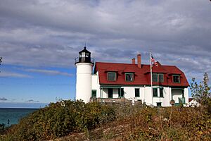
Point Betsie Light overlooking Lake Michigan
|
|

Location within Benzie County
|
|
| Country | United States |
| State | Michigan |
| County | Benzie |
| Area | |
| • Total | 35.1 sq mi (91.0 km2) |
| • Land | 23.4 sq mi (60.6 km2) |
| • Water | 11.7 sq mi (30.4 km2) |
| Elevation | 597 ft (182 m) |
| Population
(2020)
|
|
| • Total | 694 |
| • Density | 32/sq mi (12.5/km2) |
| Time zone | UTC-5 (Eastern (EST)) |
| • Summer (DST) | UTC-4 (EDT) |
| ZIP code(s) |
49617, 49635, 49640
|
| Area code(s) | 231 |
| FIPS code | 26-44240 |
| GNIS feature ID | 1626572 |
Lake Township is a special kind of local government area called a civil township in Benzie County, Michigan. It's located in the U.S. state of Michigan. In 2020, about 694 people lived here.
The township has a unique shape because it follows the beautiful shore of Lake Michigan. It stretches from Crystal Lake all the way north to the border of Leelanau County. A part of the famous Sleeping Bear Dunes National Lakeshore is also found in the northern area of the township.
Contents
Places in Lake Township
Aral: A Ghost Town Story
Aral is what we call a ghost town. This means it was once a busy place but is now mostly empty. It was built in 1880 where Otter Creek meets Lake Michigan. The town grew around the Otter Creek Lumber Mill, which was a big sawmill.
It was named after a place called Aral in Ireland. This was because another place in Michigan already had the name "Otter Creek." Aral even had its own post office from 1884 until 1900. You can find its old location at 44°45′44″N 86°4′29.3″W / 44.76222°N 86.074806°W.
Crystal Downs Country Club
Crystal Downs Country Club is another important place in the western part of Lake Township. It is a census-designated place, which means it's an area that the government counts as a specific community for population records.
Exploring Lake Township's Geography
Lake Township covers a total area of about 91 square kilometers. A big part of this area, about 30.4 square kilometers, is water! This means nearly a third of the township is covered by water.
Beautiful Lakes and Rivers
The township has long shorelines on both Lake Michigan and Crystal Lake. These beautiful lakes make Lake Township a very popular spot for vacations and tourism. People love to visit for the water and scenery.
The Platte River also flows through the township. It eventually empties into Lake Michigan right here. You can find where the Platte River meets Lake Michigan at 44°43′54″N 86°9′10″W / 44.73167°N 86.15278°W.
Main Roads
 M-22 is a major highway that runs through Lake Township. It mostly goes from west to east, following along the coast of Lake Michigan. This road helps people travel easily through the area and enjoy the lakeside views.
Who Lives in Lake Township?
According to a count done in 2000, there were 635 people living in Lake Township. Most of the people living here were White. A small number of people were Native American or from two or more races.
The township has many households, and about 68.9% of them were married couples living together. Many people living in Lake Township are 65 years old or older, making it a quiet and peaceful place for many residents. The average age of people living here was 61 years old.
See also
 In Spanish: Municipio de Lake (condado de Benzie) para niños


