
Arapuni Suspension Bridge facts for kids
Quick facts for kids Arapuni Suspension Bridge |
|
|---|---|

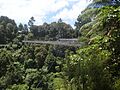
Arapuni Suspension Bridge, with the photo taken from the true right of the Waikato River
|
|
| Coordinates | 38°04′14″S 175°38′40″E / 38.0706°S 175.6445°E |
| Carries | Pedestrians and cyclists |
| Crosses | Waikato River |
| Locale | South Waikato District |
| Heritage status | NZHPT – Category II |
| Characteristics | |
| Design | Suspension bridge |
| Material | Steel cables Steel lattice tower Timber deck |
| Total length | 152.4 m |
| Width | 1.57 m (between handrails) |
| Number of spans | One |
| Piers in water | Nil |
| Clearance below | 54 m |
| History | |
| Designer | David Rowell & Co. |
| Constructed by | Armstrong Whitworth |
| Construction begin | May 1925 |
| Construction end | 1926 |
| Designated: | 21 April 1994 |
| Reference #: | 4168 |
The Arapuni Suspension Bridge is a cool bridge in New Zealand. It crosses the Waikato River in the South Waikato District. This bridge was built in the 1920s. It was made to help workers get to the Arapuni Power Station construction site. The bridge is about 152 meters (500 feet) long. It hangs high above a beautiful, bush-lined gorge.
History of the Bridge

The Arapuni Suspension Bridge is located about 1.5 kilometers (1 mile) downstream from the Arapuni Dam. This bridge was a small but important part of a huge building project. At the time, the Arapuni power station was New Zealand's biggest engineering job.
Building the bridge started in May 1925. It was finished sometime between April and July 1926. There wasn't a big party or official opening for the bridge. It was simply ready when the workers needed it.
The bridge connected a place called "top camp" to the other side of the gorge. "Top camp" later became the town of Arapuni. This camp was home to the workers building the power station. The bridge helped them get to their work areas easily.
On April 21, 1994, the bridge was recognized as a special historic place. The Historic Places Trust gave it a Category II historic place status. This means it's an important part of New Zealand's history.
How the Bridge Was Built

The bridge was designed by a company called David Rowell & Co. from London, England. It's thought that the parts of the bridge were made in England. Then, they were shipped to New Zealand and put together here. The British company Armstrong Whitworth built the bridge. They were also the main contractors for the Arapuni dam and power station.
This bridge is one of the longest footbridges in New Zealand. It stretches 152.4 meters (500 feet) across the gorge. One side of the bridge is about 8 meters (26 feet) higher than the other. It has a tall steel tower on the left side of the river (when looking downstream). On the right side, the bridge's base is built right into the river bank. The cables that hold up the bridge are anchored into the cliff on this side.
Visiting the Bridge Today
The Arapuni Suspension Bridge is a popular spot for visitors. You can get to it by walking along a path that starts from Arapuni Road.
When you cross the bridge, you get amazing views of the scenic gorge. You can see cool rock formations. The cliffs on the right side of the bridge are made of volcanic rock. These rocks have interesting cracks from when they cooled down a long, long time ago.
Sometimes, people mistakenly call it the Arapuni "Swing Bridge." Even some signs might say that. But it's actually a suspension bridge. In New Zealand, people often use "swing bridge" to describe footbridges that swing a little.
The bridge will also be part of the Waikato River Trails. This is a walking and cycling path that is being built along the Waikato River.
Images for kids
-
Arapuni Suspension Bridge seen from downstream. You can see the cables that help keep it steady.

