Waikato River Trails facts for kids
Quick facts for kids Waikato River Trails |
|
|---|---|

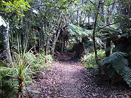
Snowsill to Atiamuri Trail in January 2010
|
|
| Length | 100 km (62 mi) |
| Location | near Atiamuri, New Zealand |
| Trailheads | Atiamuri / Horahora |
| Use | Walking Cycling |
| Difficulty | Average to difficult |
| Season | Year round |
| Sights | Waikato River Hydropower lakes and dams Arapuni Suspension Bridge |
| Hazards | Cliffs |
The Waikato River Trails are awesome paths for both walking and cycling along the famous Waikato River in New Zealand. These trails were first dreamed up by local leaders and groups. In 2009, they became one of the first big projects for the New Zealand Cycle Trail. The plan is for the trails to be 100 kilometers long. About half of this was already built before the new cycle trail plan started. The last parts of the trails were finished in 2011, and they officially opened in November of that year.
Contents
Where are the Waikato River Trails Located?
The Waikato River Trails are found in the Waikato Region of New Zealand. They follow the Waikato River and go through different areas like South Waikato, Otorohanga, and Taupo.
There are currently seven different sections of the trails you can explore:
- Arapuni Village to Arapuni Dam
- Arapuni Dam to Jones Landing
- Whakamaru Dam to Whakamaru Reserve
- Ongaroto Bluffs Trail
- Whakamaru Christian Camp to Snowsill
- Dunham Creek Mobility Trail
- Atiamuri Trail
For example, the Whakamaru Christian Camp to Snowsill trail is about 3 kilometers long. It takes around 30 minutes to walk. The Whakamaru Camp is also a cool spot if you want to go camping!
How Did the Waikato River Trails Start?
The idea for the Waikato River Trails began in September 2003. A group called the South Waikato Economic Development Trust created a team to manage the trails. Later, in February 2006, the Waikato River Trails Trust was officially formed to look after them.
The very first part of the trail, a 3-kilometer section from Arapuni Dam to Jones Landing, opened in 2004. This was the start of the whole building project.
A big moment happened on November 10, 2009. New Zealand's Prime Minister, John Key, officially started the building of the first New Zealand Cycle Trail project. This took place at the Little Waipa Reserve, right next to the Waikato River. It was a historic day! In April 2010, the first building contract was signed. This brought in $3.4 million to build the final 41 kilometers of the 100-kilometer trail. Plus, many volunteers helped out, adding about $1.5 million worth of work!
The trails were planned to open in time for the 2010 World Rowing Championships. These championships were held at Lake Karapiro, near Cambridge, from October 29 to November 7. It's thought that about 20,000 people visit the trails each year, mostly from the Auckland and Waikato areas.
What Can You Do on the Waikato River Trails?
At first, the trails were only meant for walking. But people started cycling on the parts that were open. So, the plan changed, and now the trails are for both walkers and cyclists! If you're cycling, they are great for families and mountain biking. The difficulty is usually easy to medium. One special part of the trail, at Dunham Creek, is even good for wheelchairs.
By early 2010, 30 kilometers of the trails were ready to use. Another 23 kilometers were built but not yet open. Six kilometers were being built, and 41 more kilometers were planned for 2010.
By September 2011, the section between Mangakino Lakefront Reserve and a new swing bridge was almost done. From the swing bridge, the trail was finished all the way to Whakamaru Reserve and the Whakamaru Dam.
The trust that manages the trails also planted 6,000 native trees. This helps restore the land along the river. They also put up 18 kilometers of fences. These fences help protect the river from the effects of nearby dairy farms.
What Cool Things Can You See on the Trails?
The Waikato River is New Zealand's longest river, stretching 425 kilometers! It's very important to the local Māori tribes, especially the large Tainui tribe. They see it as a source of their mana, which means their pride and spiritual power.
There are several lakes along this part of the Waikato River that were created by dams:
- Lake Atiamuri was formed by the Atiamuri Power Station.
- Lake Whakamaru was created by the Whakamaru Power Station.
- Lake Maraetai is a calm and pretty lake near the town of Mangakino. It's about 4.4 square kilometers. At the lakefront in Mangakino, you can find the cool Bus Stop Cafe. There's also plenty of parking and free camping spots for tents and campervans. You can find BBQs, power, and toilets there.
- Lake Waipapa is where the Waipapa River flows into the Waikato River.
- Lake Arapuni was formed by the Arapuni Dam.
- Lake Karapiro was the last of eight power stations built on the Waikato River, created in 1947.
Don't miss the Arapuni Suspension Bridge! It's a popular spot for visitors and stretches 152 meters across the river. It's located just below the Arapuni Power Station.
The Taniwha is a fun multi-sport event that uses the Waikato River Trails. It has different distances, from 7 to 88 kilometers, for bikers, runners, and walkers. This event usually happens in November.
Who Helps Support the Trails?
Mercury Energy is a big supporter of the Waikato River Trails Trust. They own and operate the power stations along the Waikato River that create electricity.
 | William Lucy |
 | Charles Hayes |
 | Cleveland Robinson |


