
Ardmore, Alabama facts for kids
Quick facts for kids
Ardmore, Alabama
|
|
|---|---|

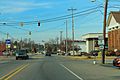
View along Ardmore Avenue (SR 53); Town Hall on the left
|
|

Location of Ardmore in Limestone County, Alabama
|
|
| Country | United States |
| State | Alabama |
| County | Limestone |
| Founded | 1922 |
| Incorporated | February 24, 1945 |
| Area | |
| • Total | 2.050 sq mi (5.310 km2) |
| • Land | 2.042 sq mi (5.290 km2) |
| • Water | 0.008 sq mi (0.022 km2) |
| Elevation | 912 ft (278 m) |
| Population
(2020)
|
|
| • Total | 1,321 |
| • Estimate
(2022)
|
1,393 |
| • Density | 644.4/sq mi (248.78/km2) |
| Time zone | UTC−6 (Central (CST)) |
| • Summer (DST) | UTC−5 (CDT) |
| ZIP Code |
35739
|
| Area code(s) | 256 and 938 |
| FIPS code | 01-02260 |
| GNIS feature ID | 2405163 |
Ardmore is a town in Limestone County, Alabama, United States. It is part of the larger Huntsville-Decatur Metro Area. In 2020, about 1,321 people lived there. Ardmore is special because it borders its sister city, Ardmore, Tennessee. This means part of the town is in Alabama and part is in Tennessee!
Contents
History of Ardmore
Ardmore wasn't always called Ardmore. It was first named Austin. This was after Alex Austin, who chose the spot for a train station. The station was for the Louisville and Nashville Railroad. The railroad company later changed the name of the town. They named it Ardmore after a community in Ardmore, Pennsylvania. Ardmore, Alabama officially became a town in 1922.
Where is Ardmore?
Ardmore is located at 34°59′13″N 86°50′36″W / 34.98694°N 86.84333°W. It is the northernmost town in the state of Alabama. The town is mostly along Alabama State Route 53. This road runs north and south along Ardmore Avenue. Then it turns east along the state line. Here, it becomes the same as Tennessee State Route 7 on Main Street.
Interstate 65 passes just west of Ardmore. This major highway connects big cities like Nashville and Birmingham.
The State Line on Main Street
Main Street in Ardmore is actually the state line itself! If you are heading north or west on Main Street, you are in Tennessee. If you are heading south or east, you are in Alabama.
The town covers about 2.050 square miles (5.310 square kilometers). Most of this area is land. Only a tiny part is water.
People of Ardmore
| Historical population | |||
|---|---|---|---|
| Census | Pop. | %± | |
| 1930 | 266 | — | |
| 1940 | 381 | 43.2% | |
| 1950 | 408 | 7.1% | |
| 1960 | 439 | 7.6% | |
| 1970 | 761 | 73.3% | |
| 1980 | 1,096 | 44.0% | |
| 1990 | 1,090 | −0.5% | |
| 2000 | 1,034 | −5.1% | |
| 2010 | 1,194 | 15.5% | |
| 2020 | 1,321 | 10.6% | |
| 2022 (est.) | 1,393 | 16.7% | |
| U.S. Decennial Census 2020 Census |
|||
Ardmore first appeared in the U.S. Census in 1930. It was listed as an official town then.
Ardmore in 2020
In 2020, there were 1,321 people living in Ardmore. There were 571 households and 344 families. About 636 homes were in the town.
Ardmore in 2010
In 2010, Ardmore had 1,194 people. There were 505 households and 333 families. The town had about 578 housing units.
About 28.1% of households had children under 18. Many households (44.8%) were married couples. About 18.5% of households had one person aged 65 or older. The average household had 2.36 people. The average family had 2.97 people.
The median age in Ardmore was 37.1 years old. About 24.9% of the population was under 18. About 16.8% was 65 or older.
Education in Ardmore
Ardmore is part of the Limestone County School District.
There is a high school in Ardmore, Alabama. It is called Ardmore High School. About 1,008 students attend this school. The school has two main parts. One part is for middle schoolers, grades six through eight. The other part is for high schoolers, grades nine through twelve.
The school was started in 1915. The land for the school cost only five dollars. It was a generous gift to the community. Residents of Ardmore helped build the school for a whole year. The first school building had two stories. The first floor had classrooms, a library, and a study hall. A stage was built on the second floor.
In 1917, Ardmore High School opened its doors to students. Ten years later, the school became officially recognized. This is called accreditation.
The school's goal has always been the same. It aims to help students grow in their learning, health, and good behavior. This helps them become helpful citizens in a changing world.
Notable People from Ardmore
- David Fanning, a country music singer, songwriter, and record producer.
- Lee Hodges, a professional golfer on the PGA Tour.
Photo Gallery
-
Ardmore road signs at the state line
-
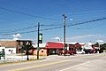
Downtown Ardmore
-
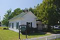
Ardmore town hall
-
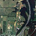
Ardmore airport
.jpg)


See also
 In Spanish: Ardmore (Alabama) para niños
