
Arecibo barrio-pueblo facts for kids
Quick facts for kids
Arecibo barrio-pueblo
Pueblo de Arecibo
|
|
|---|---|
|
Municipality Seat
|
|

Town Hall in Arecibo
|
|

Location of Arecibo barrio-pueblo within the municipality of Arecibo shown in red
|
|
| Lua error in Module:Location_map at line 416: Malformed coordinates value. | |
| Commonwealth | |
| Municipality | |
| Area | |
| • Total | 2.62 sq mi (6.8 km2) |
| • Land | 1.41 sq mi (3.7 km2) |
| • Water | 1.21 sq mi (3.1 km2) |
| Elevation | 23 ft (7 m) |
| Population
(2010)
|
|
| • Total | 8,488 |
| • Density | 5,935.7/sq mi (2,291.8/km2) |
| Source: 2010 Census | |
| Time zone | UTC−4 (AST) |
Arecibo barrio-pueblo is like the main downtown area of Arecibo, a city in Puerto Rico. It's where the local government offices are located. In 2010, about 8,488 people lived here.
Just like in Spain, many towns in Puerto Rico have a special area called a pueblo. This area usually has a main square (plaza), the city hall, and a Catholic church. Every year, fun festivals called Fiestas patronales (patron saint festivals) are held in this central plaza.
Contents
The Central Plaza and Its Church
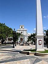
The main plaza, or town square, is a popular spot for events and for people to meet up. It's a place where friends and families can gather and hang out from morning until night. In the early 1800s, Spanish laws called the Laws of the Indies guided how towns in Puerto Rico were built. These laws said that the plaza should be a good size for celebrations. They also said that the streets around the plaza should have covered walkways. These walkways would protect people from the sun and rain.
Right across from the central plaza in Arecibo barrio-pueblo is the Catedral San Felipe Apostól. This is the second-largest Roman Catholic church in Puerto Rico. It was first built in 1616. Later, it was rebuilt in 1793. After an earthquake in 1918 damaged its roof, it was repaired using strong concrete.
History of Arecibo Pueblo
Puerto Rico became a territory of the United States after the Spanish–American War. This happened because of the Treaty of Paris of 1898. In 1899, the U.S. government took a census (a count of the population) in Puerto Rico. They found that 8,008 people lived in Arecibo Pueblo at that time.
| Historical population | |||
|---|---|---|---|
| Census | Pop. | %± | |
| 1900 | 8,008 | — | |
| 1950 | 28,659 | — | |
| 1980 | 14,279 | — | |
| 1990 | 11,954 | −16.3% | |
| 2000 | 10,596 | −11.4% | |
| 2010 | 8,488 | −19.9% | |
| U.S. Decennial Census 1899 (shown as 1900) 1910-1930 1930-1950 1980-2000 2010 |
|||
A special house called Casa de la Diosa Mita (The House of Goddess Mita) is also in Arecibo barrio-pueblo. This house is listed on the National Register of Historic Places. It was the home where Juanita "Mita" García Peraza started the Mita Congregation, a religious group.
Sectors of Arecibo Pueblo
Barrios, like Arecibo barrio-pueblo, are often divided into smaller areas. These smaller areas are called sectores (which means sectors in English). The names for these sectors can be different. Some are simply called sector, while others might be called urbanización, reparto, barriada, or residencial.
Here are some of the sectors you can find in Arecibo barrio-pueblo:
- Avenida 65 de Infantería
- Avenida Constitución
- Avenida Cotto
- Avenida San Luis
- Calle Los Héroes
- Calles: Ledesma, Cruz Roja, Caribe, Avenida Miramar
- Comunidad Barrio Obrero
- Comunidad La Múcura
- Condominios del Atlántico
- Reparto Cotto Viejo
- Reparto San Juan
- Residencial Bella Vista
- Residencial Extensión Zeno Gandía
- Residencial Ramón Marín
- Residencial Trina Padilla
- Urbanización Centro Urbano
- Urbanización Radioville
- Urbanización Zeno Gandía
Gallery
Places in Arecibo barrio-pueblo:
-
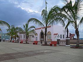
Plaza Colon
-
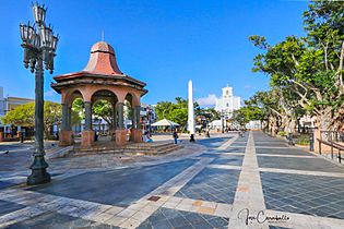
Square
-
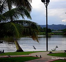
Passive park Parque Doctor Rivera Aulet
-
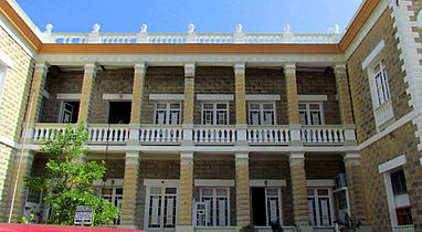
Antiguo Edificio Suliveres
-
Plaza and Cathedral in Arecibo


.jpg)
See also
 In Spanish: Arecibo (Arecibo) para niños
- List of communities in Puerto Rico
- List of barrios and sectors of Arecibo, Puerto Rico
- National Register of Historic Places listings in northern Puerto Rico
