Argyle, Georgia facts for kids
Quick facts for kids
Argyle, Georgia
|
|
|---|---|

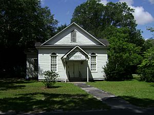
Argyle Community Center
|
|

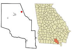
Location in Clinch County and the state of Georgia
|
|
| Country | United States |
| State | Georgia |
| County | Clinch |
| Area | |
| • Total | 1.72 sq mi (4.45 km2) |
| • Land | 1.72 sq mi (4.45 km2) |
| • Water | 0.00 sq mi (0.00 km2) |
| Elevation | 161 ft (49 m) |
| Population
(2020)
|
|
| • Total | 190 |
| • Density | 110.53/sq mi (42.66/km2) |
| Time zone | UTC-5 (Eastern (EST)) |
| • Summer (DST) | UTC-4 (EDT) |
| ZIP code |
31623
|
| Area code(s) | 912 |
| FIPS code | 13-02844 |
| GNIS feature ID | 0354387 |
Argyle is a small town in Clinch County, Georgia, in the United States. In 2020, about 190 people lived there. It's a quiet place in the southern part of Georgia.
Contents
A Look Back at Argyle's History
The town of Argyle got its name from Fort Argyle. This fort is located near the city of Savannah.
A post office opened in Argyle in 1882. This means people could send and receive mail there. The town officially became a town in 1901. This is called being "incorporated."
Where is Argyle Located?
Argyle is located in Georgia at these coordinates: 31°04′26″N 82°38′57″W / 31.073938°N 82.649276°W.
The United States Census Bureau says the town is about 1.7 square miles (4.4 square kilometers) in size. All of this area is land.
Argyle's Weather
The weather in Argyle is usually warm. It gets rain throughout the year. This type of weather is known as a Humid subtropical climate. On climate maps, you might see it called "Cfa." This means it has hot, humid summers and mild winters.
| Climate data for Argyle, Georgia | |||||||||||||
|---|---|---|---|---|---|---|---|---|---|---|---|---|---|
| Month | Jan | Feb | Mar | Apr | May | Jun | Jul | Aug | Sep | Oct | Nov | Dec | Year |
| Mean daily maximum °C (°F) | 17 (62) |
19 (66) |
23 (73) |
27 (80) |
30 (86) |
32 (90) |
33 (92) |
33 (91) |
31 (87) |
27 (80) |
22 (72) |
18 (64) |
26 (79) |
| Mean daily minimum °C (°F) | 3 (37) |
4 (40) |
7 (45) |
11 (51) |
15 (59) |
19 (66) |
21 (69) |
21 (69) |
18 (65) |
12 (54) |
7 (45) |
4 (39) |
12 (53) |
| Average precipitation mm (inches) | 110 (4.5) |
100 (4.1) |
120 (4.8) |
84 (3.3) |
89 (3.5) |
140 (5.6) |
160 (6.4) |
160 (6.2) |
110 (4.3) |
66 (2.6) |
64 (2.5) |
89 (3.5) |
1,310 (51.4) |
| Source: Weatherbase | |||||||||||||
Who Lives in Argyle?
Every ten years, the United States counts its population. This count is called a census. It helps us know how many people live in different places.
| Historical population | |||
|---|---|---|---|
| Census | Pop. | %± | |
| 1910 | 180 | — | |
| 1920 | 332 | 84.4% | |
| 1930 | 311 | −6.3% | |
| 1940 | 278 | −10.6% | |
| 1950 | 244 | −12.2% | |
| 1960 | 225 | −7.8% | |
| 1970 | 206 | −8.4% | |
| 1980 | 206 | 0.0% | |
| 1990 | 206 | 0.0% | |
| 2000 | 151 | −26.7% | |
| 2010 | 212 | 40.4% | |
| 2020 | 190 | −10.4% | |
| U.S. Decennial Census 1850-1870 1870-1880 1890-1910 1920-1930 1940 1950 1960 1970 1980 1990 2000 2010 |
|||
In the year 2000, the census showed that 151 people lived in Argyle. There were 49 households, which are groups of people living together. By the 2020 census, the population had grown to 190 people.
See also
 In Spanish: Argyle (Georgia) para niños
 | Tommie Smith |
 | Simone Manuel |
 | Shani Davis |
 | Simone Biles |
 | Alice Coachman |

