Argyll, Queensland facts for kids
Quick facts for kids ArgyllQueensland |
|||||||||||||||
|---|---|---|---|---|---|---|---|---|---|---|---|---|---|---|---|

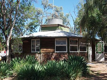
Tomahawk Creek Huts: The Lodge, 2011
|
|||||||||||||||
| Population | 25 (2021 census) | ||||||||||||||
| • Density | 0.0397/km2 (0.103/sq mi) | ||||||||||||||
| Postcode(s) | 4721 | ||||||||||||||
| Area | 629.1 km2 (242.9 sq mi) | ||||||||||||||
| Time zone | AEST (UTC+10:00) | ||||||||||||||
| LGA(s) | Central Highlands Region | ||||||||||||||
| State electorate(s) | Gregory | ||||||||||||||
| Federal Division(s) | Flynn | ||||||||||||||
|
|||||||||||||||
Argyll is a small rural area in Queensland, Australia. It's known as a locality, which is like a small district or neighborhood. Argyll is located in the Central Highlands Region. In 2021, only 25 people lived here.
History
The borders of Argyll have changed a few times over the years. This happens when the government decides to adjust the size or shape of different areas.
- In 2019, a nearby locality called Mistake Creek was closed down. Its land was added to other areas like Clermont and Peak Vale. Argyll's borders were also slightly changed during this time.
- In 2020, the Queensland Government made more changes. They created three new localities: Rubyvale, Sapphire Central, and Anakie Siding. To make room for these new areas, Argyll lost some of its land in the southeast. This part of Argyll became part of the new Rubyvale and Sapphire Central areas.
Who Lives in Argyll?
The number of people living in Argyll is quite small.
- In 2016, about 31 people called Argyll home.
- By 2021, the population had decreased to 25 people.
Special Places in Argyll
Argyll has some important historical sites. These are called heritage-listed sites. They are protected because they tell us about the past.
- One special place is the Tomahawk Creek Huts.
Black History Month on Kiddle
African-American Ballerinas:
 | Precious Adams |
 | Lauren Anderson |
 | Janet Collins |

All content from Kiddle encyclopedia articles (including the article images and facts) can be freely used under Attribution-ShareAlike license, unless stated otherwise. Cite this article:
Argyll, Queensland Facts for Kids. Kiddle Encyclopedia.

