Clermont, Queensland facts for kids
Quick facts for kids ClermontQueensland |
|||||||||||||||
|---|---|---|---|---|---|---|---|---|---|---|---|---|---|---|---|
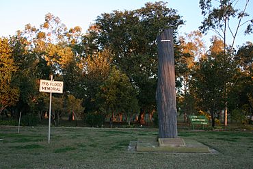
Memorial marking the 1916 flood
|
|||||||||||||||
| Population | 2,952 (2021 census) | ||||||||||||||
| • Density | 0.57222/km2 (1.4820/sq mi) | ||||||||||||||
| Established | 1864 | ||||||||||||||
| Postcode(s) | 4721 | ||||||||||||||
| Elevation | 267.0 m (876 ft) | ||||||||||||||
| Area | 5,158.9 km2 (1,991.9 sq mi) | ||||||||||||||
| Time zone | AEST (UTC+10:00) | ||||||||||||||
| Location |
|
||||||||||||||
| LGA(s) | Isaac | ||||||||||||||
| State electorate(s) | Burdekin | ||||||||||||||
| Federal Division(s) | Capricornia | ||||||||||||||
|
|||||||||||||||
|
|||||||||||||||
Clermont is a town and area in the Isaac Region of Queensland, Australia. It's a rural place, meaning it's mostly countryside. In 2021, about 2,952 people lived in Clermont.
The town is a main centre for the large coal mines nearby. It also provides services for the many farms and agricultural properties in the area.
Contents
Exploring Clermont's Location
Clermont is located about 274 kilometers (170 miles) south-west of Mackay. It sits where two major roads meet: the Gregory Highway and the Peak Downs Highway.
Historic Copperfield
Close to Clermont, about 4 kilometers (2.5 miles) south-west, are the historic towns of North Copperfield and South Copperfield. People often call them just Copperfield.
Main Roads and Connections
The Gregory Highway passes through the eastern part of Clermont. The Peak Downs Highway also comes into the town from the east. The Clermont Connection Road links the Gregory Highway to the town center. Another road, the Clermont-Alpha Road, starts in the town center and goes south-west.
Clermont's Past: A Journey Through Time
The land around Clermont belongs to the Gangulu people, an Aboriginal group. Their traditional country includes Clermont and nearby areas.
Early Discoveries and Settlement
A European explorer named Ludwig Leichhardt was the first to travel through the Clermont area in 1845. But the town truly began in 1861 when gold was discovered. This brought many people to the area, which was originally Babbinburra clan land.
Clermont was officially named a town on March 25, 1864. It was named after Clermont-Ferrand in France. This was the home of Oscar de Satge, an early European farmer in the area.
Communication and Early Buildings
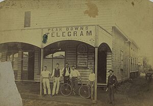
The first post office in the area opened in 1863. By 1864, it was called the Clermont Post Office. The first newspaper, the Peak Downs Telegram, started in 1864. In 1935, Clermont was an important link for public telephone calls.
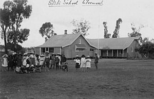
The first Catholic church in Clermont opened in 1866. Clermont State School, an important part of the community, opened on August 27, 1867.
Mining and Community Growth
After gold, copper was also found. In the 1880s, many Chinese people came to Clermont to mine for gold and copper. A famous soldier, Billy Sing, was born in Clermont in 1886. His father was Chinese and his mother was English.
The railway line reached Clermont in February 1884, connecting it to Emerald. However, today there are no passenger trains to Clermont.
The Great Flood of 1916
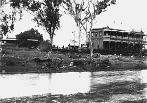
Clermont was first built on low ground near a lagoon (a small lake). Because of this, flooding was a big problem. There were four major floods between 1864 and 1896.
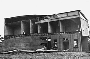
The worst flood happened in 1916. It sadly killed 65 people out of a town population of 1,500. This makes it one of Australia's worst natural disasters in terms of lives lost. After this terrible flood, many of the town's wooden buildings were moved to higher ground. They used steam engines to pull the buildings! A local photographer, Gordon Pullar, took many pictures of this amazing event.
Modern Developments
The Clermont public library opened in 1962. Clermont State School started offering secondary education (Years 8-12) in 1959. Later, a separate school, Clermont State High School, opened in 1990 for older students.
People of Clermont
In 2021, the population of Clermont was 2,952 people. The number of people living in Clermont has changed over the years. In 2011, there were 2,177 people, and in 2016, there were 3,031 people.
Important Historic Places
Clermont has several places that are listed for their historical importance:
- Cemetery Road: Clermont Cemetery
- 739 Fleurs Lane: Stone Farm Building
- Oaky Creek, 20 km (12 mi) West of Clermont on the Clermont-Alpha Road: Irlam's Ant Bed Building
Coal Mining in Clermont
Clermont is a very important area for coal mining.
Clermont Mine
Glencore operates the Clermont Mine, which is about 12 kilometers (7.5 miles) north-west of the town. This mine produces a lot of thermal coal, which is used for energy in other countries. It can produce up to 12.2 million tonnes of coal each year. The first coal from this mine was sent out in April 2010.
Blair Athol Coal Mine
Another large coal mine, the Blair Athol coal mine, was located about 20 kilometers (12 miles) north-west of Clermont. This mine also supplied thermal coal to countries in Asia and Europe. Coal was first found here in 1864 and mined in 1890. The mine closed on November 26, 2012, after all its coal was dug out. Its storage and train facilities are now used by the Clermont Mine.
Learning in Clermont
Clermont has several schools for students of different ages.
Clermont State School
Clermont State School is a government primary school for students from Prep (kindergarten) to Year 6. It is located on Hetherington Street. In 2017, it had 237 students.
Clermont State High School
Clermont State High School is a government secondary school for students from Year 7 to Year 12. You can find it on Kitchener Street. In 2017, 182 students attended this school.
St Joseph's Catholic Primary School
St Joseph's Catholic Primary School is a Catholic primary school for students from Prep to Year 6. It is located on Box Street. In 2017, 106 students were enrolled here.
Mistake Creek State School
Mistake Creek State School is another government primary school for students from Prep to Year 6. It is located on Alpha Road. In 2017, it had 14 students. This school is now within the larger area of Clermont.
What Clermont Offers
Clermont has several useful services and places for its residents.
- The Isaac Regional Council runs a public library at the corner of Karmoo and Herschel Street.
- The Clermont branch of the Queensland Country Women's Association (QCWA) meets at their rooms on 28 Sirus Street.
- Clermont Uniting Church is located at 40 Box Street, on the corner of Capella Street.
- The Clermont aerodrome is about 3.5 nautical miles (6.5 km) north-northeast of the town.
Fun Places to Visit
The Clermont Historical Centre is a great place to learn about the area's past. It has displays about the history of settlement, farming, and mining in Clermont and nearby towns like Copperfield and Blair Athol.
 | Aaron Henry |
 | T. R. M. Howard |
 | Jesse Jackson |


