
Arneytown, New Jersey facts for kids
Quick facts for kids
Arneytown, New Jersey
|
|
|---|---|

Approaching the center of Arneytown on eastbound CR 664
|
|

Arneytown, New Jersey
Location in Burlington County, New Jersey

Arneytown, New Jersey
Location in Monmouth County, New Jersey

Arneytown, New Jersey
Location in New Jersey

Arneytown, New Jersey
Location in the United States
|
|
| Country | |
| State | |
| Counties | Burlington and Monmouth |
| Townships | North Hanover and Upper Freehold |
| Elevation | 164 ft (50 m) |
| Time zone | UTC−05:00 (Eastern (EST)) |
| • Summer (DST) | UTC−04:00 (Eastern (EDT)) |
| Area codes | 609, 640 |
| GNIS feature ID | 874381 |
Arneytown is a small community in New Jersey. It's not a separate town, but part of two different areas: North Hanover Township in Burlington County and Upper Freehold Township in Monmouth County.
Arneytown is located about 2 miles north of Jacobstown. It sits along Province Line Road. This road used to be an important boundary. It marked the line between the old Provinces of East Jersey and West Jersey.
In the 1700s, Quaker settlers called this area Upper Freehold. Later, in 1827, a post office opened here. That's when the community officially became known as Arneytown.
Contents
Exploring Arneytown's Past
Arneytown has a rich history. Many buildings here show what life was like long ago.
The Old Arneytown Tavern
One important building is the Arneytown Tavern. It's also called the Lawrie House. This tavern was built around 1731. Imagine how old that is!
Records show it was a busy tavern by 1762. Back then, William Lawrie sold it to Richard Platt. It was a place where travelers could stop and rest.
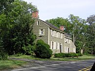
Arneytown Historic District
|
Arneytown Historic District
|
|

Lawrie House
|
|
| Location | Province Line Road (Ellisdale-Arneytown Road) and Chesterfield-Arneytown Road |
|---|---|
| Area | 58 acres (23 ha) |
| Built | 1731 |
| Architectural style | Greek Revival, Georgian |
| NRHP reference No. | 67451850 |
| Significant dates | |
| Added to NRHP | December 12, 1977 |
A special part of Arneytown is called the Arneytown Historic District. This area covers 58 acres. It's like a protected neighborhood of old buildings.
It was added to the National Register of Historic Places in 1977. This means it's recognized as important for its history and architecture. The district has 12 buildings that help tell its story.
Important Buildings in the District
Some buildings in the historic district are very famous. They have been studied by the Historic American Buildings Survey. These include the Lawrie House, which is the old tavern. The Duncan Mackenzie Place and Emley-Wilde House are also important. These buildings show different styles, like Greek Revival and Georgian.
Veterans Memorial Cemetery
South of Arneytown, there is a large cemetery. It is called the Brigadier General William C. Doyle Veterans Memorial Cemetery. This cemetery covers 225 acres.
It was opened on May 30, 1986, by Governor Thomas Kean. The cemetery was named after Brigadier General William C. Doyle in 1989. It honors people who served in the military.
Images for kids
-
Late 18th-century house
.JPG)
