Upper Freehold Township, New Jersey facts for kids
Quick facts for kids
Upper Freehold Township, New Jersey
|
||
|---|---|---|
|
Township
|
||
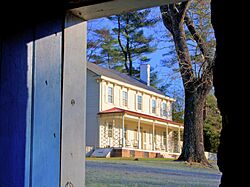
The historic Waln House
|
||
|
||

Location of Upper Freehold Township in Monmouth County highlighted in yellow (right). Inset map: Location of Monmouth County in New Jersey highlighted in black (left).
|
||
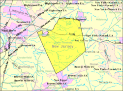
Census Bureau map of Upper Freehold Township, New Jersey
|
||
| Country | ||
| State | ||
| County | Monmouth | |
| Established | 1731 | |
| Incorporated | February 21, 1798 | |
| Government | ||
| • Type | Township | |
| • Body | Township Committee | |
| Area | ||
| • Total | 47.37 sq mi (122.68 km2) | |
| • Land | 46.48 sq mi (120.37 km2) | |
| • Water | 0.89 sq mi (2.31 km2) 1.88% | |
| Area rank | 35th of 565 in state 3rd of 53 in county |
|
| Elevation | 108 ft (33 m) | |
| Population
(2020)
|
||
| • Total | 7,273 | |
| • Estimate
(2023)
|
7,203 | |
| • Rank | 313th of 565 in state 24th of 53 in county |
|
| • Density | 156.5/sq mi (60.4/km2) | |
| • Density rank | 518th of 565 in state 53rd of 53 in county |
|
| Time zone | UTC−05:00 (Eastern (EST)) | |
| • Summer (DST) | UTC−04:00 (Eastern (EDT)) | |
| ZIP Code |
08501 - Allentown 08514 - Cream Ridge
|
|
| Area code(s) | 609 exchanges: 208, 259, 752, 758 | |
| FIPS code | 3402574900 | |
| GNIS feature ID | 0882114 | |
Upper Freehold Township is a community located in Monmouth County, New Jersey. It's a township, which is a type of local government area. In 2020, about 7,273 people lived here. This was a small increase from 2010.
Contents
History of Upper Freehold Township

Upper Freehold Township has a long history, starting in 1731. It was created from parts of Freehold Township. The name "Freehold" comes from an old English legal term. It means owning land completely, without having to pay rent or service to anyone else.
The township officially became a township on February 21, 1798. Over the years, some parts of Upper Freehold Township were used to form new towns. These include Millstone Township in 1844, Jackson Township in 1844, and Allentown in 1889.
Geography and Natural Areas
Upper Freehold Township covers about 47.37 square miles (122.68 square kilometers). Most of this area is land, with a small part being water.
Many small communities are located within the township. Some of these include Arneytown, Cream Ridge, and Walnford.
The township shares its borders with several other towns. These include Allentown and Millstone Township in Monmouth County. It also borders towns in Burlington County, Mercer County, and Ocean County.
Farming has always been very important in Upper Freehold Township. A large amount of land, about 6,000 acres, is protected from new buildings. This is part of a special program to preserve farmland. Local voters even approved using property taxes to help fund this program.
The Assunpink Wildlife Preservation Area is also partly in the township. This large preserve has wetlands and lakes. It's a great place to see migratory birds. You can also enjoy mountain biking, horseback riding, and hiking trails there.
Population and Demographics
| Historical population | |||
|---|---|---|---|
| Census | Pop. | %± | |
| 1790 | 3,442 | — | |
| 1810 | 3,843 | — | |
| 1820 | 4,541 | 18.2% | |
| 1830 | 4,826 | 6.3% | |
| 1840 | 5,026 | 4.1% | |
| 1850 | 2,566 | * | −48.9% |
| 1860 | 3,198 | 24.6% | |
| 1870 | 3,640 | 13.8% | |
| 1880 | 3,236 | −11.1% | |
| 1890 | 2,861 | * | −11.6% |
| 1900 | 2,112 | −26.2% | |
| 1910 | 2,053 | −2.8% | |
| 1920 | 1,737 | −15.4% | |
| 1930 | 1,867 | 7.5% | |
| 1940 | 1,839 | −1.5% | |
| 1950 | 2,193 | 19.2% | |
| 1960 | 2,363 | 7.8% | |
| 1970 | 2,551 | 8.0% | |
| 1980 | 2,750 | 7.8% | |
| 1990 | 3,277 | 19.2% | |
| 2000 | 4,282 | 30.7% | |
| 2010 | 6,902 | 61.2% | |
| 2020 | 7,273 | 5.4% | |
| 2023 (est.) | 7,203 | 4.4% | |
| Population sources: 1790–1920 1840 1850–1870 1850 1870 1880–1890 1900–1910 1910–1930 1940–2000 2000 2010 2020 * = Lost territory in previous decade. |
|||
In 2010, Upper Freehold Township had 6,902 people living there. Most residents were White. There were also smaller groups of Black or African American, Asian, and other races. About 3.68% of the population identified as Hispanic or Latino.
The average household had about 2.92 people. Many households were married couples with children. The median age of residents was 43.7 years old. This means half the people were younger than 43.7 and half were older.
Parks and Recreation
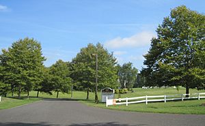
Upper Freehold Township offers many places for fun and outdoor activities.
- The Horse Park of New Jersey: This park opened in 1987. It was created by people who loved horses and wanted a dedicated space for horse activities. It's a central spot for horse events in Monmouth County.
- Monmouth County Parks:
- Clayton Park: This park covers 438 acres. It's a quiet place with woodlands and hiking trails. The land was bought in 1978 to make sure it would be preserved.
- Historic Walnford: This site includes a restored Georgian-style house and a working mill. It shows what an industrial community was like almost 200 years ago.
- Crosswicks Creek Greenbelt: This area includes 328 acres in the township. It runs along the Crosswicks Creek and is great for enjoying nature.
- Byron Johnson Recreation Area: In 2000, plans were made to develop this area. It now has soccer fields, baseball fields, and basketball courts. It's located near Allentown High School.
Education
Students in Upper Freehold Township attend public schools through the Upper Freehold Regional School District. This district serves students from both Allentown Borough and Upper Freehold Township. Students from Millstone Township also attend the high school.
The district has three schools:
- Newell Elementary School: For students in pre-kindergarten through 4th grade.
- Stone Bridge Middle School: For students in 5th through 8th grades.
- Allentown High School: For students in 9th through 12th grades.
A board of education oversees the district. Its nine members are elected by voters.
Transportation and Roads
Upper Freehold Township has over 116 miles of roads. Most of these are maintained by the township itself.
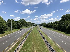
- Interstate 195: A major highway, about 5.7 miles of it runs through the township. It's an important road for residents. Exit 11 leads to the Horse Park of New Jersey.
- County Routes: Several county roads cross the township. These include County Route 539, County Route 524, County Route 526, and County Route 537. These roads connect the township to nearby areas.
- New Jersey Turnpike: This major highway is just a few minutes away. You can reach it via I-195 in nearby Robbinsville Township.
Points of Interest
Here are some interesting places to visit in Upper Freehold Township:
- Cream Ridge Winery
- Monmouth County Park System – This includes Clayton Park, Crosswicks Creek Park, and Historic Walnford.
- Imlaystown – A historic community within the township.
Notable People from Upper Freehold Township
Many interesting people have lived in or are connected to Upper Freehold Township:
- James Cox (1753–1810): A politician who served in the United States House of Representatives.
- John H. Froude (born 1930): A politician who served in the New Jersey General Assembly.
- Joseph Holmes (1736–1809): A politician who served on the Upper Freehold Township Committee.
- Gilbert Imlay (1754–1828): A businessman, author, and diplomat.
- Elisha Lawrence (1746–1799): A politician who served as Vice-President of Council.
- Linda K. Meirs (1884–1972): An American Red Cross and Army nurse during World War I. She received the Florence Nightingale Medal.
- Ross Scheuerman (born 1993): A running back for the Hamilton Tiger-Cats football team.
- Chris Tomson (born 1984): The drummer for the band Vampire Weekend.
- Samuel G. Wright (1781–1845): A politician elected to the U.S. House of Representatives.
See also
 In Spanish: Municipio de Upper Freehold para niños
 | Laphonza Butler |
 | Daisy Bates |
 | Elizabeth Piper Ensley |


