
Allentown, New Jersey facts for kids
Quick facts for kids
Allentown, New Jersey
|
|
|---|---|
|
Borough
|
|

Allentown Mill in the center of town
|
|

Location of Allentown in Monmouth County highlighted in red (left). Inset map: Location of Monmouth County in New Jersey highlighted in orange (right).
|
|

Census Bureau map of Allentown, New Jersey
<mapframe text="Interactive map of Allentown, New Jersey" zoom="8" width="250" height="250"> { "type": "ExternalData", "service": "geoshape", "ids": "Q1085875" } </mapframe> |
|

Allentown, New Jersey
Location in Monmouth County, New Jersey

Allentown, New Jersey
Location in New Jersey

Allentown, New Jersey
Location in the United States
|
|
| Country | |
| State | |
| County | Monmouth |
| Incorporated | January 29, 1889 |
| Named for | Nathan Allen or William Allen |
| Government | |
| • Type | Borough |
| • Body | Borough Council |
| Area | |
| • Total | 0.62 sq mi (1.61 km2) |
| • Land | 0.60 sq mi (1.54 km2) |
| • Water | 0.03 sq mi (0.06 km2) 4.03% |
| Area rank | 537th of 565 in state 45th of 53 in county |
| Elevation | 75 ft (23 m) |
| Population
(2020)
|
|
| • Total | 1,734 |
| • Estimate
(2023)
|
1,724 |
| • Rank | 498th of 565 in state 44th of 53 in county |
| • Density | 2,908.5/sq mi (1,123.0/km2) |
| • Density rank | 223rd of 565 in state 26th of 53 in county |
| Time zone | UTC−05:00 (Eastern (EST)) |
| • Summer (DST) | UTC−04:00 (Eastern (EDT)) |
| ZIP Code |
08501
|
| Area codes | 609 Exchanges: 259, 752, 758 |
| FIPS code | 3402500760 |
| GNIS feature ID | 0885137 |
| Website | |
Allentown is a small town, called a borough, in western Monmouth County, New Jersey. It's located right next to Mercer County. In 2020, about 1,734 people lived here. Allentown is in the middle part of New Jersey, almost exactly halfway between New York City and Philadelphia.
Contents
History of Allentown
Allentown became an official borough on January 29, 1889. This happened after people in the area voted for it. The town was named after either Nathan Allen or William Allen. William Allen was an important judge in Pennsylvania a long time ago.
Geography of Allentown
Allentown is a pretty small place. It covers about 0.62 square miles (1.61 square kilometers). Most of that area is land, and a tiny bit is water.
Allentown shares its borders with two other towns. These are Upper Freehold Township in Monmouth County and Robbinsville Township in Mercer County.
Allentown's Economy and Shops

Allentown has a nice shopping area with unique antique and specialty shops. You can also find many restaurants here. The borough is home to many historic houses and buildings.
The Horse Park of New Jersey is a large park for horse events. It's located very close to Allentown and uses an Allentown mailing address. Heritage Park is another park right within the borough, near the main shopping area.
In 2002, Allentown was named a 'Village Center'. This helps the town get extra state money. This money is used to protect historic sites and natural areas that might be at risk. For bigger shopping trips, there are large malls nearby. These include Freehold Raceway Mall, Quaker Bridge Mall, and Princeton Market Fair.
Allentown Population Facts
| Historical population | |||
|---|---|---|---|
| Census | Pop. | %± | |
| 1900 | 695 | — | |
| 1910 | 634 | −8.8% | |
| 1920 | 634 | 0.0% | |
| 1930 | 706 | 11.4% | |
| 1940 | 766 | 8.5% | |
| 1950 | 931 | 21.5% | |
| 1960 | 1,393 | 49.6% | |
| 1970 | 1,603 | 15.1% | |
| 1980 | 1,962 | 22.4% | |
| 1990 | 1,828 | −6.8% | |
| 2000 | 1,882 | 3.0% | |
| 2010 | 1,828 | −2.9% | |
| 2020 | 1,734 | −5.1% | |
| 2023 (est.) | 1,724 | −5.7% | |
| Population sources: 1900–1920 1900–1910 1910–1930 1940–2000 2010 2020 |
|||
Population in 2010
In 2010, there were 1,828 people living in Allentown. There were 704 households, which are groups of people living together. About 499 of these were families.
Most people in Allentown were White (about 91%). About 4.4% were Black or African American. Around 1.5% were Asian. About 3.6% of the population was Hispanic or Latino.
About 24.8% of the people were under 18 years old. Around 11.4% were 65 years or older. The average age in Allentown was 42.4 years.
Education in Allentown
Students in Allentown go to public schools in the Upper Freehold Regional School District. This district also includes students from Upper Freehold Township. Students from Millstone Township also attend the high school here.
The school district has three schools:
- Newell Elementary School: For students in Pre-Kindergarten through 4th grade.
- Stone Bridge Middle School: For students in 5th through 8th grade.
- Allentown High School: For students in 9th through 12th grade.
In the 2021-2022 school year, there were 2,124 students in the district. There were about 176 teachers, meaning there were about 12 students for every teacher. A group of nine people called the board of education manages the schools. Four of these board members are from Allentown.
Allentown Historic District
|
Allentown Historic District
|
|
.JPG)
Allentown Presbyterian Church
|
|
| Location | Portions of North and South Main streets, Church, Pearl and Hamilton streets, Lakeview Drive and Yardville Road. |
|---|---|
| Area | 17 acres (6.9 ha) |
| Architectural style | Late Victorian, Georgian, Federal |
| NRHP reference No. | 82003284 |
| Significant dates | |
| Added to NRHP | June 14, 1982 |
The Allentown Historic District is a special area in town. It covers about 17 acres and includes many old buildings. This district was added to the National Register of Historic Places in 1982. It's important because of its architecture, businesses, education, and transportation history. The district has 219 buildings that help tell its story. The Allentown Mill is one of these important buildings.
The Allentown Presbyterian Church was built in 1837. It has a style called Greek Revival architecture. The John Imlay House, built around 1790, is another historic building with a Georgian-style. The Ephraim Robbins House is now used as the Borough Hall. The old First Baptist Church building is now the Allentown Public Library.
-
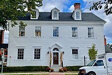
John Imlay House
-
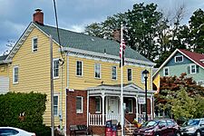
Ephraim Robbins House
-
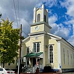
Former First Baptist Church
-
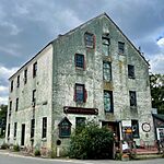
Allentown Mill


Transportation in Allentown
_at_Waker_Avenue_in_Allentown,_Monmouth_County,_New_Jersey.jpg)
As of 2010, Allentown had about 6.84 miles of roads. The town itself took care of 4.55 miles of these roads. Monmouth County maintained the other 2.29 miles.
The main roads that go through Allentown are County Route 524, County Route 526, and County Route 539.
Bigger highways are also easy to reach from Allentown. These include Interstate 195 and the New Jersey Turnpike (Interstate 95).
Allentown is about an hour's drive southwest of Manhattan (New York City). It's also about 50 minutes northeast of Philadelphia. You can easily get to Princeton and Trenton from Allentown using Interstate 195.
Notable people
Many interesting people have lived in or are connected to Allentown:
- Doc Imlay (1889–1948), a baseball pitcher who played for the Philadelphia Phillies.
- William Longstreet (1759–1814), an inventor who designed a better cotton gin and a steamboat.
- Tom McCarthy (born 1968), a TV announcer for the Philadelphia Phillies baseball team.
- Linda K. Meirs (1884–1972), an American Red Cross and Army nurse during World War I. She was one of the first Americans to receive the Florence Nightingale Medal.
- George Middleton (1800–1888), a politician who represented New Jersey in Congress.
- John B. Montgomery (1794–1872), a United States Navy officer during the American Civil War.
- William A. Newell (1817–1901), a doctor and politician.
- George R. Robbins (1814–1875), a politician who represented New Jersey in the U.S. House of Representatives.
- Warren Lincoln Rogers (1877–1938), a bishop in the Episcopal Church.
- Billy Schuler (born 1990), a soccer player.
See also
 In Spanish: Allentown (Nueva Jersey) para niños
