Arram Beck facts for kids
Quick facts for kids Arram Beck |
|
|---|---|

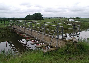
A bridge over the Beck between the River Hull and the Beverley and Barmston Drain. The River Hull can be seen at the upper right.
|
|
| Country | England |
| County | East Riding of Yorkshire |
| Physical characteristics | |
| Main source | Arram 0 ft (0 m) |
| River mouth | River Hull 0 ft (0 m) |
Arram Beck is a small stream in the East Riding of Yorkshire, England. It flows east from the village of Arram and joins the River Hull. The water level in the Beck changes because the River Hull is affected by tides. Many fish live here, like perch, dace, and roach. Chub fish have also been added to the Beck.
Contents
The Story of Arram Beck
Arram Beck has an interesting past. It's not just a simple stream!
Crossing Other Waterways
Close to where it meets the River Hull, Arram Beck flows over the Beverley and Barmston Drain. This drain runs next to the Driffield Navigation and the river. The drain was created by a special law passed in 1798. To build it, eleven tunnels were needed to go under existing waterways, including Arram Beck. William Chapman was the engineer who designed these tunnels in 1796.
Once Used by Boats
Frederick Reynard, who lived nearby, said in 1906 that Arram Beck was sometimes used by small boats in the 1800s. However, by 1894, boats no longer used it. The Beck is only about 660 yards (600 m) long, so it was likely only for very small boats.
Helping with Floods
In the 1990s, the Environment Agency worked to reduce flooding in the area. As part of this effort, another stream called Aike Beck was redirected to flow into Arram Beck. This helped manage water levels and prevent floods.
Where is Arram Beck?
Arram Beck is connected to the River Hull. Here are some points of interest along its path:
- Upstream: The next place you'd find upstream on the River Hull is the Leven Canal.
- Downstream: The next place downstream on the River Hull is Beverley Beck.
| Point | Coordinates (Links to map resources) |
OS Grid Ref | Notes |
|---|---|---|---|
| Source near Arram | 53°52′56″N 0°24′47″W / 53.8821°N 0.4131°W | TA044440 | |
| Junction with River Hull | 53°52′54″N 0°24′28″W / 53.8818°N 0.4079°W | TA047440 |
 | John T. Biggers |
 | Thomas Blackshear |
 | Mark Bradford |
 | Beverly Buchanan |

