Aike Beck facts for kids
Quick facts for kids Aike Beck |
|
|---|---|

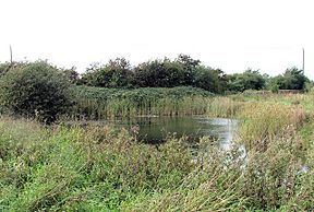
A small pond near Beck Lane, Aike is the only part of Aike Beck still in water
|
|
| Specifications | |
| Locks | 2 |
| Status | defunct |
| History | |
| Original owner | Hotham family |
| Date completed | 1790s |
| Date closed | 1850s |
| Geography | |
| Start point | Lockington Landing |
| End point | Aike |
| Connects to | River Hull |
Aike Beck, also known as the Lockington Navigation, was once a small stream in the East Riding of Yorkshire, England. It was made into a waterway for boats in the late 1700s. However, it stopped being used for this purpose around the 1850s. Its water came from Bryan Mills Beck and Scorborough Beck. In 1988, these water sources were moved to feed into Arram Beck instead. Most of Aike Beck's original channel was then filled in.
Contents
History of Aike Beck
Aike Beck joined the River Hull about 0.4 miles (0.6 km) upstream from where the Leven Canal meets the river. Boats could travel on Aike Beck for about 2 miles (3.2 km) from the River Hull.
What Was Aike Beck Used For?
The main job of Aike Beck was to carry coal. It also moved farm fertiliser. Larger boats called keel boats would bring goods to the start of Aike Beck. Then, these goods were moved onto smaller, flatter boats that could travel on the shallower water of the beck. These smaller boats were pulled by horses or even people to Lockington wharf.
Aike Beck had two special gates called canal locks. These locks helped boats move between different water levels. Each lock was big enough for boats that were about 40 feet (12 meters) long and 8 feet 10 inches (2.7 meters) wide.
- One lock was at the entrance where Aike Beck met the River Hull.
- The second lock was about halfway along the waterway.
Below the middle lock, Aike Beck was made wider. Above this lock, the path of the waterway was made much straighter than the original winding stream.
Who Built It?
The Hotham family built this waterway in the late 1700s. They owned a lot of land in the area. Aike Beck even crossed over another waterway called the Beverley and Barmston Drain. The drain went underneath Aike Beck through a special tunnel.
In 1809, an engineer named William Chapman looked at the area. He told the people in charge of drainage that the locks on Aike Beck were causing water levels to rise. This led to some flooding nearby.
Why Did It Stop Being Used?
In the 1840s, a railway line called the Hull and Selby Railway (Bridlington branch) was being built. The Hotham family made a deal with the railway company. The railway company agreed not to build places to handle coal near Aike Beck. This was to protect the business of the canal.
It is believed that Aike Beck stopped being used for boats around the 1850s. Old maps from 1855 show that the second lock and the coal loading area at Lockington were marked as "old." By 1891, the very last part of the waterway, from the beck to the coal wharf, had completely disappeared. The lock gates must have been taken away because the beck was then affected by the tides, even beyond where the coal wharf used to be.
Changes in Modern Times
Aike Beck used to get its water from Bryan Mills Beck and Scorborough Beck. Scorborough Beck was also used for boats in the early 1800s.
In 1988, big changes were made to Aike Beck and Arram Beck. Aike Beck's connection to the River Hull was completely removed. The water from Scorborough Beck and Bryan Mills Beck was sent south along a new drain. This drain runs next to the railway line and joins Arram Beck.
Most of the original path of Aike Beck was filled in. The material used to fill it came from the raised banks on either side of the channel. Today, only a small part of Aike Beck still has water. You can find it near Beck Lane in Aike. There's also a slight dip in the bank of the River Hull where Aike Beck used to enter.
The spot where Aike Beck used to join the river is important. It marks the point where the Driffield Navigation (upstream from the junction) becomes the River Hull (below it).
Location
Aike Beck was situated on the Driffield Navigation.
- Next place upstream = Wilfholme Landing
- Next place downstream = Leven Canal
Points of interest
| Point | Coordinates (Links to map resources) |
OS Grid Ref | Notes |
|---|---|---|---|
| Lockington Landing | 53°54′28″N 0°26′14″W / 53.9077°N 0.4373°W | TA027468 | Coal wharf |
| Second lock | 53°54′08″N 0°25′07″W / 53.9022°N 0.4186°W | TA040462 | |
| Entrance lock | 53°53′45″N 0°23′47″W / 53.8959°N 0.3964°W | TA054456 | Jn with River Hull |
 | Aaron Henry |
 | T. R. M. Howard |
 | Jesse Jackson |

