Beverley and Barmston Drain facts for kids
The Beverley and Barmston Drain is a major channel built to help drain land in the East Riding of Yorkshire, England. It runs west of the River Hull. This area used to be very wet, with salt marshes in the south and carrs (wet, boggy land) in the north. Water came from the higher Wolds hills and from the Humber when the tide came in.
People tried to stop the flooding as early as the 1300s by building earth banks. By the 1600s, windpumps were used to lift water out of the land. Another big drainage project, the Holderness Drain, was finished in 1772. After that, people focused on fixing the flooding in the carrs.
Engineers suggested building more banks along the River Hull and digging a new, lower channel to carry water away. But there were disagreements. The Port of Hull wanted the water to flow into the river to help clean out their harbour. Also, the Holderness Drainage group wanted to make sure their land stayed dry, even if it meant the land to the west flooded first.
Despite these challenges, the Beverley and Barmston Drainage Act was passed in 1798. Work began to build about 23 miles (37 km) of new drainage channels. The main channel runs mostly straight, next to the River Hull. Water from the north-east was sent to a new outlet at Barmston on the coast.
Even after the drain was built, flooding was still a problem because the banks were not allowed to be very high. Over time, new solutions were found. In 1880, an agreement was made to dredge the river and raise the banks on both sides. Pumping stations, first using steam, then diesel, and now electric pumps, were built at places like Arram Beck and Hempholme to help move the water.
The way these drainage systems are managed has also changed over the years. Old laws were replaced, and responsibility for the drains passed through several groups. Today, the Environment Agency and local internal drainage boards (IDBs) look after the drain and its smaller channels.
Contents
Why Was Drainage Needed?
After the Romans left Britain, the River Hull valley was mostly a huge marsh. This marsh stretched from the Humber almost up to Driffield. It was between 2 and 5 miles (3.2 and 8.0 km) wide. There were small islands of higher ground scattered throughout the marsh.
People lived on these islands during the Iron Age and Roman times. By the 1000s, more settlements appeared in the southern marshy areas. But much of the region remained a lake. This lake was fed by springs from the chalk hills (the Wolds) and by the tide coming in twice a day from the Humber.
Early Attempts to Control Water
Around the 1300s, people started building earth banks. These banks helped protect the land from the tides coming in from the Humber and the lower River Hull. But keeping these banks in good repair was a constant challenge. For example, in 1311, King Edward II had to appoint special groups to fix broken banks.
While the banks stopped the tide, they also trapped fresh water coming from the north. So, people dug drainage channels to carry this fresh water to sluices (gates) in the main flood banks. Some early channels were dug by monks from Meaux Abbey. These were probably used for boats as well as for drainage.
In 1532, a law called the Statute of Sewers was passed. This law made land drainage more organised. It set up Commissioners of Sewers. These commissioners could check banks, assign maintenance work, and fine people who didn't do their part.
By the early 1600s, the southern salt marshes were mostly free from flooding. This was thanks to a large flood bank built at Sutton-on-Hull. However, this bank stopped water from the northern carrs from flowing into the marshes. As a result, the carrs stayed waterlogged.
People suggested new ways to drain the carrs from the 1660s onwards. In 1675, a local landowner, Sir Joseph Ashe, dug a drain from Wawne carrs to the Hull. He used windmills to pump the water into the river. Other landowners soon followed his example.
The Big Drainage Schemes
A major step forward happened in 1764. A group called Holderness Drainage got a special law passed by Parliament. This law meant their land, east of the River Hull, was no longer under the old Court of Sewers. They hired engineers John Smeaton and John Grundy, Jr. to plan their drainage system.
The main Holderness Drain was finished by October 1767. Work on banks and drains continued until 1772, costing £24,000. Because this project was so successful, areas west of the river also wanted better drainage.
The Beverley and Skidby Drainage Act of 1785 was passed to improve an area near Beverley. This involved digging a new drain to carry water further down the Hull. Flooding in these areas was not as bad as in the carrs further north. So, in 1796, landowners started thinking about how to fix the carrs' flooding problem.
Facing Challenges and Opposition
The Holderness Drain's outlet was built on the Hull at Stoneferry, not directly into the Humber. This was because the Port of Hull wanted the fresh water to flow into the Hull. They believed it would help clean out the Old Harbour by washing away silt.
The new Beverley and Barmston scheme faced similar opposition. Not only from the Port of Hull, but also from the Holderness Drainage Commissioners. They set strict rules for any new scheme. For example, new banks on the west side of the river had to be far from their banks. They also insisted that new banks couldn't be higher than their own. This was to make sure that if there was a flood, the west side would flood first, protecting the east. The landowners had to agree to these conditions.
Engineers agreed that to succeed, the Hull and its smaller rivers needed banks. Also, water from the carrs needed to be carried away by a separate, lower drain. Several ideas for an outlet were suggested. These included sending the water into the sea at Barmston or into the Humber.
However, the Port of Hull and other powerful groups pushed for the water to enter the Hull. They even promised money to help clean and deepen the Old Harbour. The landowners gave in to this pressure, though it's not clear if the money was ever spent.
Building the Drain
The Beverley and Barmston Drainage Act was finally approved in 1798. Work then began. William Chapman was the Chief Engineer. He oversaw the building of 23 miles (37 km) of drainage channels. He also supervised 20 miles (32 km) of embankments along the River Hull. A 2-mile (3.2 km) long channel, the Barmston cut, was also built.
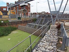
At the southern end, a sluice gate was built to let water into the Hull. The main channel needed 11 tunnels to pass under existing waterways. There were also 27 road bridges and many other smaller bridges and culverts. The whole project cost £115,000 by the time it was finished in 1810. It protected about 12,600 acres (51 km²) of land from flooding.
At the northern end, channels were made deeper. The Barmston cut carried water to the sea at Barmston. A barrier was built at Foston on the Wolds to stop water from north Holderness from flowing west to the Hull. This part became a separate drainage area. The lower banks, needed to satisfy the Holderness Drainage, were built near Grovehill.
How the Drain is Managed Today
Before the 1930s, most land drainage laws were based on Henry VIII's Statute of Sewers from 1531. This old law was very confusing. A Royal Commission in 1927 said the laws were "vague and ill-defined" and "chaotic."
Their ideas led to the Land Drainage Act 1930. This new law created catchment boards for main rivers and internal drainage boards (IDBs) for local drainage. The River Hull, the Beverley and Barmston Drain, and the Holderness Drain all became the responsibility of the Hull Catchment Board. Smaller channels were managed by IDBs.
Over the years, responsibility changed hands several times. It went from the Hull and East Yorkshire River Board to the Yorkshire Ouse and Hull River Authority, then to the Yorkshire Water Authority. After water companies became private in 1989, the waterways were managed by the National Rivers Authority. This group became part of the Environment Agency in 1995.
Technology also changed. Steam pumps were replaced by diesel pumps, and then by electric pumping stations. For example, a new electric pumping station was built at Hempholme in 1983. It lifts water from the low-level Roam Drain into the higher Mickley Dike. A diesel pumping station at Wilfholme was replaced by electric pumps in 1982. Both are now managed by the Environment Agency.
Sculcoates power station was built next to the drain in 1898. It used water from the drain for cooling.
The smaller channels that feed into the Beverley and Barmston Drain are managed by the Beverley and North Holderness IDB. This board was formed in 1981 by merging several smaller IDBs. They manage about 163 miles (262 km) of drainage channels. These channels help protect about 92 square miles (238 km²) of land from flooding. About 64 square miles (166 km²) of this land relies on pumps for protection.
Where Does the Drain Go?
The Beverley and Barmston Drain begins at a tunnel. This tunnel is under the Driffield Navigation, just north of Hempholme Lock. To the north, other drains run alongside the Navigation. The Roam Drain joins from the east.
The drain then flows south-west, passing the Tophill Low Water Treatment Works. This area includes the Tophill Low nature reserve, which is a special protected site for nature. The River Hull winds its way to the east of these works. There is a public path along the east bank of the drain.
At Wilfholme Landing, the drain briefly meets the river again. It then passes under Watton Beck through a tunnel. The Wilfholme Pumping Station pumps some water into the river here. The river then curves away, but the drain continues its straight path towards Aike.
The footpath leaves the drain for a short time, heading towards Aike village. It rejoins the drain near a tunnel that used to carry the drain under Aike Beck. This part was later rerouted and filled in. Near Arram, another tunnel carries the drain under Arram Beck. The drain then turns more to the south, reaching Hull Bridge at Tickton, where the footpath ends.
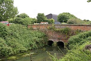
The drain crosses Swine Moor. Then it turns south-east to pass under Beverley Beck. This structure is called a bridge, aqueduct, or tunnel. It's made of red brick with stone decorations and has three arches. It has been a Grade II Listed structure since 2001, meaning it's historically important.
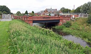
At Woodmansey, the Wilberforce Way, a long-distance footpath created in 2007, briefly follows the drain's banks. In its final section, the drain is separated from the river by farms and houses as it goes through the edge of Kingston upon Hull. A Grade II Listed bridge carries Lockwood Street over the drain. This bridge is from the late 1800s and is made of wrought iron. Soon after, the drain flows into the River Hull through a sluice gate.
 | John T. Biggers |
 | Thomas Blackshear |
 | Mark Bradford |
 | Beverly Buchanan |


