Arrondissement of Saint-Étienne facts for kids
Quick facts for kids
Arrondissement of Saint-Étienne
|
|
|---|---|

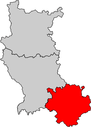
Location of Saint-Étienne in Loire
|
|
| Country | France |
| Region | Auvergne-Rhône-Alpes |
| Department | Loire |
| Communes | 75 |
| Prefecture | Saint-Étienne |
| INSEE code | 423 |
| Area | |
| • Total | 1,041.2 km2 (402.0 sq mi) |
| Population
(2014)
|
|
| • Total | 411,402 |
| • Density | 395.123/km2 (1,023.36/sq mi) |
The arrondissement of Saint-Étienne is like a special district in France. It's part of the Loire area, which is a 'department' (like a county). This department is in the Auvergne-Rhône-Alpes 'region' (a larger area). The main city, or 'capital', of this district is Saint-Étienne. It's also the main city for the whole Loire department.
History
The Saint-Étienne district has been around for a long time. It was created in 1793 when the Loire department was first formed.
Geography
The Saint-Étienne district is located in the southern part of the Loire department. It shares borders with several other departments. To the north and northeast, it's next to the Rhône department. To the east, you'll find the Isère department. The Ardèche department is to the southeast. To the southwest is the Haute-Loire department. Finally, to the northwest, it borders the Montbrison district.
Even though it's the smallest district in the Loire department, it has the most people. Its area is about 1,041 square kilometers (402 square miles). In 2014, over 411,000 people lived here. This means it's a very busy place, with many people living close together.
What Makes Up the District?
Cantons
In France, 'cantons' are like smaller areas that help organize elections. They are not always fully inside one district.
The Saint-Étienne district includes parts of 12 cantons:
- Andrézieux-Bouthéon (partly)
- Firminy
- Le Pilat
- Rive-de-Gier
- Saint-Chamond
- Saint-Étienne-1
- Saint-Étienne-2
- Saint-Étienne-3
- Saint-Étienne-4
- Saint-Étienne-5
- Saint-Étienne-6
- Sorbiers
Communes
'Communes' are like towns or villages in France. The Saint-Étienne district has 75 communes. Here are some of them:
- Andrézieux-Bouthéon
- Bessey
- Bourg-Argental
- Burdignes
- Çaloire
- Cellieu
- Chagnon
- Châteauneuf
- Chavanay
- Chuyer
- Colombier
- Dargoire
- Doizieux
- Farnay
- Firminy
- Fontanès
- Fraisses
- Genilac
- Graix
- Jonzieux
- La Chapelle-Villars
- La Fouillouse
- La Grand-Croix
- La Ricamarie
- La Talaudière
- La Terrasse-sur-Dorlay
- La Tour-en-Jarez
- La Valla-en-Gier
- La Versanne
- Le Bessat
- Le Chambon-Feugerolles
- L'Étrat
- L'Horme
- Lorette
- Lupé
- Maclas
- Malleval
- Marcenod
- Marlhes
- Pavezin
- Pélussin
- Planfoy
- Rive-de-Gier
- Roche-la-Molière
- Roisey
- Saint-Appolinard
- Saint-Chamond
- Saint-Christo-en-Jarez
- Sainte-Croix-en-Jarez
- Saint-Étienne
- Saint-Genest-Lerpt
- Saint-Genest-Malifaux
- Saint-Héand
- Saint-Jean-Bonnefonds
- Saint-Joseph
- Saint-Julien-Molin-Molette
- Saint-Martin-la-Plaine
- Saint-Michel-sur-Rhône
- Saint-Paul-en-Cornillon
- Saint-Paul-en-Jarez
- Saint-Pierre-de-Bœuf
- Saint-Priest-en-Jarez
- Saint-Régis-du-Coin
- Saint-Romain-en-Jarez
- Saint-Romain-les-Atheux
- Saint-Sauveur-en-Rue
- Sorbiers
- Tarentaise
- Tartaras
- Thélis-la-Combe
- Unieux
- Valfleury
- Véranne
- Vérin
- Villars
Here are some of the communes with the most people living in them:
| Commune | Population (2014) |
Canton |
|---|---|---|
| Saint-Étienne | 170,761 | Saint-Étienne-1, Saint-Étienne-2, Saint-Étienne-3 Saint-Étienne-4, Saint-Étienne-5, Saint-Étienne-6 |
| Saint-Chamond | 35,097 | Saint-Chamond |
| Firminy | 16,931 | Firminy |
| Rive-de-Gier | 14,730 | Rive-de-Gier |
| Le Chambon-Feugerolles | 12,582 | Saint-Étienne-2 |
| Roche-la-Molière | 9,925 | Saint-Étienne-3 |
| Andrézieux-Bouthéon | 9,876 | Andrézieux-Bouthéon |
| Unieux | 8,927 | Firminy |
| Villars | 8,054 | Saint-Étienne-4 |
| Sorbiers | 7,985 | Sorbiers |
Related pages
See also
 In Spanish: Distrito de Saint-Étienne para niños
 | Jessica Watkins |
 | Robert Henry Lawrence Jr. |
 | Mae Jemison |
 | Sian Proctor |
 | Guion Bluford |

