Arthur H. Robinson facts for kids
Quick facts for kids
Arthur H. Robinson
|
|
|---|---|
 |
|
| Born | January 5, 1915 Montreal, Quebec, Canada
|
| Died | October 10, 2004 (aged 89) Madison, Wisconsin, U.S.
|
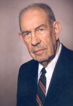
Arthur H. Robinson (born January 5, 1915 – died October 10, 2004) was an American geographer and cartographer (a person who makes maps). He was a professor in the Geography Department at the University of Wisconsin–Madison from 1947 until he retired in 1980. He wrote many books and had a big influence on how maps are designed. One of his most famous creations is the Robinson projection map, which he designed in 1961.
Contents
Biography
Arthur H. Robinson was born in Montreal, Quebec, Canada. His parents were American. He lived in Great Britain when he was young. He later went to college in the United States. He earned his first degree from Miami University in 1936.
While studying, he became very interested in making maps. He practiced drawing maps for textbooks. He earned a master's degree in geography from the University of Wisconsin–Madison in 1938. Later, he received his Ph.D. degree from Ohio State University in 1947.
World War II Contributions
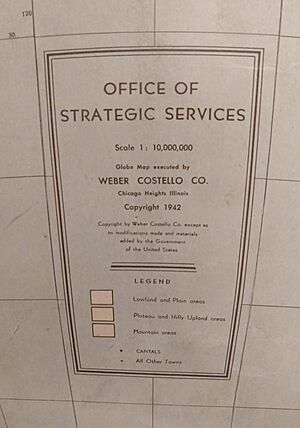
During World War II, Robinson worked for the Office of Strategic Services (OSS). This was a U.S. intelligence agency. In 1941, when Robinson joined, there were not many people who specialized in making maps like we know them today. Robinson gathered geographers who were interested in maps. Together, they learned and improved their mapmaking skills on the job.
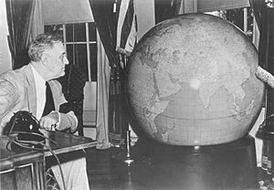
Robinson led the OSS mapmakers to create a huge 50-inch globe for President Franklin D. Roosevelt. This globe became famous as "The President's Globe". A copy of this globe was given to Winston Churchill, the Prime Minister of the United Kingdom. A third globe was made for other important leaders.
While working for the OSS, Robinson oversaw the creation of 5,000 hand-drawn maps. He also attended important meetings with Allied leaders in Quebec and Cairo in 1943. In 1944, he was the chief U.S. map officer. For his hard work, Robinson received the Legion of Merit award from the United States Army in 1946.
Academic Career
In 1947, Robinson joined the geography department at the University of Wisconsin–Madison. He spent his career there teaching and doing research. Robinson worked hard to make cartography (mapmaking) a recognized field of study. Eventually, the university offered both undergraduate and master's degrees in cartography.
The cartography program at Wisconsin has awarded many degrees. Many students who earned their Ph.D.s from this program went on to create respected mapmaking programs at other universities. Today, the map library at the University of Wisconsin–Madison is named in his honor.
Robinson also served as president of the International Cartographic Association from 1972 to 1976. He was also vice president and president of the Association of American Geographers. In 1980, he received the Carl Mannerfelt Gold Medal from the International Cartographic Association.
Personal life
Robinson married Mary Elizabeth Coffin on December 23, 1938. They had two children, a son and a daughter. After his first wife passed away, Robinson married again in 1993. His second wife was Martha Elizabeth Rodabaugh Phillips. They had gone to school together in Oxford, Ohio.
Work
Arthur Robinson was a very active writer and thinker about maps. He believed that maps should be designed so that all the information looks like one complete picture. He thought that every part of a map should be clear and easy to read. Also, each item on the map should be just as important as it needs to be, not more or less.
Robinson, like other mapmakers, warned against simply following old rules when designing maps. For example, he questioned why north is always at the top of a map. He wrote that there was no real reason why north had to be at the top.
- In his book The Look of Maps (1952), Robinson said that mapmakers should think about how a map will be used. This should be a key part of the design process.
- In The Nature of Maps (1976), Robinson and co-author Barbara Bartz Petchenik created the term "map percipient". This means a map user who really thinks about and understands the map, not just someone who glances at it. They believed that how maps work as a way to share information between the mapmaker and the user needed more study.
- Robinson also helped write a popular textbook called Elements of Cartography. The last edition of this book was published in 1995.
Robinson projection

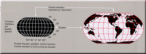
One of Robinson's most famous achievements is the Robinson projection. In 1961, a company called Rand McNally asked Robinson to create a new world map. They wanted a map that was continuous (not broken up), had less distortion (things looking stretched or squished), and looked good to people.
Robinson couldn't find an existing map projection that met all these needs. So, Rand McNally asked him to design a new one. Robinson worked through many tries to create a pseudo-cylindrical projection. This type of map tries to find a good balance. It aims to reduce how much areas and distances are distorted, making the world look more natural.
The Robinson projection became very popular after it was introduced. In 1988, the National Geographic Society started using it for their world maps. However, they changed to the Winkel tripel projection in 1998.
See also
 In Spanish: Arthur H. Robinson para niños
- Rand McNally
- Nicolas Auguste Tissot
- David Woodward
- Geographers on Film
 | Ernest Everett Just |
 | Mary Jackson |
 | Emmett Chappelle |
 | Marie Maynard Daly |


