
Map projection facts for kids

A map projection is a special way to show the round surface of our Earth (or any sphere) on a flat map. Think of it like trying to flatten an orange peel without tearing or stretching it – it's tricky! Maps are flat, but the Earth is round, so we need map projections to make them.
The challenge with these projections is that they always change the Earth's surface a little bit. This change is called distortion. Depending on what the map is for, some distortions are okay. That's why there are many different map projections, each designed for a specific use.
A famous mathematician, Carl Friedrich Gauss, proved that it's impossible to flatten a sphere perfectly without stretching or squishing parts of it.
To understand map projections, imagine a bright light, a globe, and a shape like a paper cone or cylinder. The light shines a "shadow" of the globe onto that shape. Then, the shape is unrolled to become a flat map. We can tell different projections apart by the type of helper shape used:
- Using a flat surface (a plane) gives us azimuthal projections.
- Using a cone gives us conical projections.
- Using a cylinder gives us cylindrical projections.
Cylindrical projections are like wrapping the globe in a cylinder and then unrolling it. Good examples are the Equirectangular projection and the Mercator projection.
Understanding Map Properties

When we look at a map, we can measure different things about the Earth's surface. These are called metric properties. Some important properties include:
- Area: How big a place is.
- Shape: The outline of a country or continent.
- Direction: Which way is north, south, east, or west.
- Bearing: The angle from one point to another.
- Distance: How far it is between two places.
- Scale: How much the map has been shrunk compared to real life.
Map projections are made to keep at least one of these properties accurate, but usually not all of them at once. Each projection handles these properties differently, either by keeping them perfect, making a compromise, or just giving a close estimate. The main goal of a map decides which projection is best to use. Because maps are used for many different things, many different projections have been created!
Images for kids
-
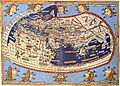
A medieval map (1482), based on Ptolemy's ideas and using his map projection.
-
.
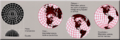
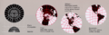
Tissot's Indicatrices on the Mercator projection, showing how shapes are distorted.
-
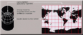
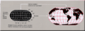
A Miller cylindrical projection maps the globe onto a cylinder.
-
This transverse Mercator projection is like a standard Mercator, but turned on its side.
-
A sinusoidal projection shows relative sizes accurately, but can make shapes look very strange.
-
An azimuthal equidistant projection shows distances and directions correctly from its center point, but distorts shapes and sizes elsewhere.
-
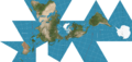
Buckminster Fuller's Dymaxion map.
-
A stereographic projection keeps shapes accurate and looks like a perspective view, but it doesn't show areas or distances correctly.
-
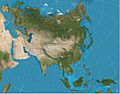
A two-point equidistant projection of Eurasia, where distances from two specific points are accurate.
-
The Gnomonic projection is thought to be the oldest map projection, developed by Thales around 600 BC.
-
The Robinson projection was used by National Geographic magazine for many years.


See also
 In Spanish: Proyección cartográfica para niños
