
Arthur Peak facts for kids
Quick facts for kids Arthur Peak |
|
|---|---|

Arthur Peak is the snow-capped mountain on right
|
|
| Highest point | |
| Elevation | 3,650 ft (1,110 m) |
| Prominence | 700 ft (210 m) |
| Isolation | 1.84 mi (2.96 km) |
| Parent peak | Peak 3850 |
| Geography | |

Arthur Peak
Location in Alaska
|
|
| Location | Tongass National Forest Juneau Borough Alaska, United States |
| Parent range | Boundary Ranges Coast Mountains |
| Topo map | USGS Taku River A-6 |
Arthur Peak is a mountain in Alaska, United States. It stands about 3,650 feet (1,113 meters) tall. This makes it a significant landmark, even if it's not the tallest mountain around. It is located in the Coast Mountains, a large mountain range.
The peak is found just east of Taku Harbor. It is also about 25 miles (40 kilometers) southeast of Juneau, the capital city of Alaska. The land around Arthur Peak is part of the Tongass National Forest, a huge protected area.
What makes Arthur Peak special is how it rises sharply from the water. It goes from sea level at Limestone Inlet, along Stephens Passage, up to its peak in just 1.3 miles (2.1 kilometers). This creates a dramatic view. The mountain was officially named in 1888 by Lieutenant Commander C. M. Thomas of the U.S. Navy.
What is the Climate Like at Arthur Peak?
Arthur Peak has a subarctic climate. This means it experiences very cold, snowy winters. Summers are usually mild, not too hot.
The weather here is greatly affected by the nearby Gulf of Alaska. Air coming from the gulf hits the tall Coast Mountains. This forces the air upwards, which causes a lot of rain and snow to fall. This process is called "orographic lift."
Temperatures can get very cold, sometimes dropping below −20 °C (−4 °F). With the wind, it can feel even colder, below −30 °C (−22 °F). If you want to visit or climb Arthur Peak, the best time is usually July. The weather is most pleasant then.
Images for kids
-
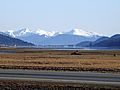
Arthur Peak is on the right side of the picture, with Peak 3850 to its left.

