Asomante, Aguada, Puerto Rico facts for kids
Quick facts for kids
Asomante
|
|
|---|---|
|
Barrio
|
|

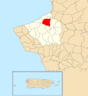
Location of Asomante within the municipality of Aguada shown in red
|
|
| Commonwealth | |
| Municipality | |
| Area | |
| • Total | 1.834 sq mi (4.75 km2) |
| • Land | 1.834 sq mi (4.75 km2) |
| • Water | 0 sq mi (0 km2) |
| Elevation | 52 ft (16 m) |
| Population
(2010)
|
|
| • Total | 3,177 |
| • Density | 1,736.1/sq mi (670.3/km2) |
| Source: 2010 Census | |
| Time zone | UTC−4 (AST) |
Asomante is a small area, called a barrio, located in the town of Aguada, Puerto Rico. In 2010, about 3,177 people lived there. It's a part of the larger Aguada urban zone.
A Look Back in Time
Puerto Rico used to be controlled by Spain. After a war called the Spanish–American War in 1898, Spain gave Puerto Rico to the United States. This happened because of an agreement called the Treaty of Paris of 1898.
After this, Puerto Rico became a territory of the United States. In 1899, the United States government counted everyone living in Puerto Rico. They found that Asomante barrio and a nearby barrio called Piedras Blancas had a combined population of 1,162 people.
| Historical population | |||
|---|---|---|---|
| Census | Pop. | %± | |
| 1950 | 466 | — | |
| 1960 | 667 | 43.1% | |
| 1980 | 1,914 | — | |
| 1990 | 2,613 | 36.5% | |
| 2000 | 3,268 | 25.1% | |
| 2010 | 3,117 | −4.6% | |
| U.S. Decennial Census 1899 (shown as 1900) 1910-1930 1930-1950 1960 1980-2000 2010 |
|||
Parts of Asomante
Barrios like Asomante are often divided into even smaller local areas. These smaller parts are called sectores (which means "sectors" in English).
There are different kinds of sectores, such as:
- sector (a general area)
- urbanización (a planned neighborhood)
- reparto (a land division)
- barriada (a settlement)
- residencial (a housing project)
Here are some of the sectors you can find in Asomante barrio:
- Apartamentos Portales del Navegante
- Avenida Rotario
- Carretera 416 (west side)
- Carretera 417 Norte
- Carretera 417 Sur
- Égida Hogar Mi Casita Feliz
- Hogar María del Carmen
- Parcelas Las Minas
- Reparto Bonet
- Residencial Aguada Gardens
- Residencial Los Almendros
- Sector Acevedo
- Sector Brisas de Coloso
- Sector Colinas del Valle
- Sector Corozas
- Sector Cuesta Los Chicharrones
- Sector Las Guabas
- Sector Los Quiñones
- Sector Muñiz
- Sector Vargas
- Sector Vertedero
- Sector Villa Alameda
- Sector Villarrubia
- Urbanización Los Flamboyanes
- Urbanización San Francisco
- Urbanización y Extensión Jardines de Aguada
- Urbanización y Extensión San José
Earthquakes and Help
Puerto Rico experienced a series of earthquakes in 2019 and 2020. During these events, the Lydia Meléndez School in Asomante became a safe place for people. Residents from nearby barrios like Cerro Gordo, Las Marías, and Atalaya had to leave their homes because of damage. The school provided them with shelter and support.
See also
 In Spanish: Asomante (Aguada) para niños
- List of communities in Puerto Rico
- List of barrios and sectors of Aguada, Puerto Rico
 | Precious Adams |
 | Lauren Anderson |
 | Janet Collins |


