Aspers, Pennsylvania facts for kids
Quick facts for kids
Aspers, Pennsylvania
|
|
|---|---|

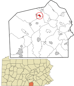
Location in Adams County and the U.S. state of Pennsylvania.
|
|
| Country | United States |
| State | Pennsylvania |
| County | Adams |
| Township | Menallen |
| Area | |
| • Total | 0.92 sq mi (2.38 km2) |
| • Land | 0.90 sq mi (2.32 km2) |
| • Water | 0.03 sq mi (0.06 km2) |
| Population
(2020)
|
|
| • Total | 486 |
| • Density | 543.02/sq mi (209.74/km2) |
| Time zone | UTC-5 (Eastern (EST)) |
| • Summer (DST) | UTC-4 (EDT) |
| FIPS code | 42-03312 |
Aspers is a small community located in Menallen Township, Adams County, Pennsylvania, United States. It is called a "census-designated place" (CDP). This means it's an area that the government defines for gathering statistics, but it doesn't have its own separate local government like a city or town. In 2020, about 486 people lived in Aspers. Before that, in 2000, it was known as the Bendersville Station-Aspers CDP.
Contents
Where is Aspers?
Aspers is located at these coordinates: 39°58′47″N 77°13′34″W / 39.97972°N 77.22611°W.
The community covers a total area of about 2.38 square kilometers (0.92 square miles). Most of this area is land, about 2.32 square kilometers (0.90 square miles). A small part, about 0.06 square kilometers (0.03 square miles), is water.
Who Lives in Aspers?
| Historical population | |||
|---|---|---|---|
| Census | Pop. | %± | |
| 2010 | 350 | — | |
| 2020 | 486 | 38.9% | |
| U.S. Decennial Census | |||
Let's look at how the population of Aspers has changed and what it's like.
Population Changes
In 2010, there were 350 people living in Aspers. By 2020, the population grew to 486 people. This shows that more people have moved to or been born in Aspers over the past decade.
Community Makeup
Back in 2000, there were 324 people living in Aspers. Most of the people were White (78.40%). There were also African American residents (4.32%) and people from other backgrounds (14.81%). About 23.77% of the population identified as Hispanic or Latino.
There were 108 households in 2000. A household is a group of people living together in one home.
- About 31.5% of these homes had children under 18.
- More than half (54.6%) were married couples.
- About 16.7% were homes where a mother lived with her children without a husband.
The average household had 3 people, and the average family had about 3 to 4 people.
Age Groups
The people in Aspers are spread across different age groups:
- About 28.4% were under 18 years old.
- About 12.7% were young adults, aged 18 to 24.
- The largest group, 29.0%, was between 25 and 44 years old.
- About 11.7% of the population was 65 years or older.
The median age in Aspers was 33 years old. This means half the people were younger than 33, and half were older.
What is the Land Like?
The land around Aspers has interesting geology. It is made up of ancient rocks from the Triassic period. These are sedimentary rocks, which means they formed from layers of sand, mud, and other materials over millions of years.
Rock Types
- On the north side of Aspers, you'll mostly find a type of rock called conglomerate. This rock is made of rounded pebbles and stones cemented together.
- To the south, the land is mostly made of shale. Shale is a soft, layered rock that forms from compacted mud.
There's also a type of rock called basalt that cuts through these older rocks near the town. Basalt is a dark, fine-grained volcanic rock. It formed when molten rock (magma) pushed its way up through the existing layers and then cooled.
See also
 In Spanish: Bendersville Station-Aspers para niños
 | Delilah Pierce |
 | Gordon Parks |
 | Augusta Savage |
 | Charles Ethan Porter |

