Athens, New York facts for kids
Quick facts for kids
Athens, New York
|
|
|---|---|

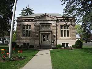
Athens Public Library
|
|

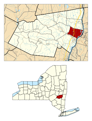
Location in Greene County and the state of New York.
|
|

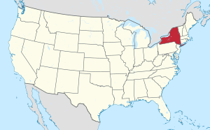
Location of New York in the United States
|
|
| Country | United States |
| State | New York |
| County | Greene |
| Area | |
| • Total | 28.87 sq mi (74.77 km2) |
| • Land | 26.25 sq mi (67.98 km2) |
| • Water | 2.62 sq mi (6.79 km2) |
| Population
(2020)
|
|
| • Total | 3,916 |
| • Density | 135.64/sq mi (52.374/km2) |
| Time zone | UTC-5 (EST) |
| • Summer (DST) | UTC-4 (EDT) |
| ZIP code |
12015
|
| Area code(s) | 518 |
| FIPS code | 36-039-02913 |
Athens is a town in Greene County, New York, United States. It's located near the eastern edge of Greene County. In 2020, about 3,916 people lived here. The town of Athens also has a village that shares the same name, Athens.
Contents
History of Athens
The town of Athens was officially started on February 25, 1815. It was created from parts of two nearby towns: Catskill and Coxsackie. By 1890, the town had a population of 2,361 people.
Geography and Climate in Athens
Athens covers about 28.8 square miles (74.7 square kilometers) in total. Most of this area is land, but about 2.7 square miles (6.9 square kilometers) is water, like rivers and lakes.
The eastern border of the town is the Hudson River, which also forms the boundary with Columbia County. Important roads like U.S. Route 9W and the New York State Thruway (Interstate 87) pass through the town.
Weather in Athens
Athens experiences different seasons throughout the year. Here's a look at the average temperatures and precipitation:
| Climate data for Athens, New York | |||||||||||||
|---|---|---|---|---|---|---|---|---|---|---|---|---|---|
| Month | Jan | Feb | Mar | Apr | May | Jun | Jul | Aug | Sep | Oct | Nov | Dec | Year |
| Record high °F (°C) | 66 (19) |
72 (22) |
85 (29) |
94 (34) |
95 (35) |
97 (36) |
103 (39) |
97 (36) |
96 (36) |
90 (32) |
82 (28) |
71 (22) |
103 (39) |
| Mean daily maximum °F (°C) | 34 (1) |
37 (3) |
47 (8) |
61 (16) |
72 (22) |
80 (27) |
85 (29) |
82 (28) |
74 (23) |
63 (17) |
50 (10) |
38 (3) |
60 (16) |
| Mean daily minimum °F (°C) | 16 (−9) |
19 (−7) |
28 (−2) |
38 (3) |
49 (9) |
58 (14) |
63 (17) |
61 (16) |
54 (12) |
42 (6) |
33 (1) |
23 (−5) |
40 (4) |
| Record low °F (°C) | −26 (−32) |
−18 (−28) |
−8 (−22) |
12 (−11) |
24 (−4) |
34 (1) |
40 (4) |
37 (3) |
27 (−3) |
18 (−8) |
5 (−15) |
−15 (−26) |
−26 (−32) |
| Average precipitation inches (mm) | 3.11 (79) |
2.46 (62) |
3.30 (84) |
3.56 (90) |
4.29 (109) |
3.82 (97) |
3.92 (100) |
3.81 (97) |
3.83 (97) |
3.47 (88) |
3.36 (85) |
3.10 (79) |
42.03 (1,068) |
| Average snowfall inches (cm) | 8.7 (22) |
7.0 (18) |
3.9 (9.9) |
1.2 (3.0) |
0 (0) |
0 (0) |
0 (0) |
0 (0) |
0 (0) |
0 (0) |
0.8 (2.0) |
6.7 (17) |
28.3 (72) |
| Source: PlantMaps | |||||||||||||
People Living in Athens (Demographics)
Here's how the population of Athens has changed over the years:
| Historical population | |||
|---|---|---|---|
| Census | Pop. | %± | |
| 1820 | 2,030 | — | |
| 1830 | 2,425 | 19.5% | |
| 1840 | 2,387 | −1.6% | |
| 1850 | 2,986 | 25.1% | |
| 1860 | 2,791 | −6.5% | |
| 1870 | 2,942 | 5.4% | |
| 1880 | 3,065 | 4.2% | |
| 1890 | 2,876 | −6.2% | |
| 1900 | 2,891 | 0.5% | |
| 1910 | 2,720 | −5.9% | |
| 1920 | 2,361 | −13.2% | |
| 1930 | 2,254 | −4.5% | |
| 1940 | 2,375 | 5.4% | |
| 1950 | 2,372 | −0.1% | |
| 1960 | 2,804 | 18.2% | |
| 1970 | 3,567 | 27.2% | |
| 1980 | 3,462 | −2.9% | |
| 1990 | 3,561 | 2.9% | |
| 2000 | 3,988 | 12.0% | |
| 2010 | 4,089 | 2.5% | |
| 2020 | 3,916 | −4.2% | |
| U.S. Decennial Census> | |||
In 2000, there were about 3,991 people living in Athens. These people lived in 1,600 households, and 1,110 of those were families. The average household had about 2.48 people.
The population was spread out by age. About 23.3% of the people were under 18 years old. The median age, which is the middle age of all the people, was 41 years.
The average income for a household in Athens was about $39,719. For families, the average income was around $43,672. About 8.7% of the total population lived below the poverty line.
Communities and Locations in the Town of Athens
The town of Athens includes several smaller communities and interesting spots:
- Athens – This is the main village, located on the eastern side of the town.
- Athens Station – You can find this area south of West Athens.
- Hollister Lake – A lake in the northwestern part of the town.
- Lime Street – A small community, or hamlet, in the northwestern part of the town.
- Middle Ground Flats – This is an island located in the Athens River.
- Sleepy Hollow Lake – A lake found at the northern border of the town.
- West Athens – A hamlet in the northeastern part of the town, located along Route 28.
- The Orchards – A neighborhood in the northwestern part of the village.
Electric Power Facilities
Athens is home to an important power plant that helps provide electricity.
New Athens Generating Plant
The New Athens Generating Company runs a large power plant here. It started operating in 2004. This plant uses natural gas to create electricity. It has three special machines called combustion turbines. The hot air from these turbines then creates steam, which spins another machine called a steam turbine. This whole process makes a lot of electricity.
In 2017, this plant produced a huge amount of electricity, about 3,891 gigawatt-hours (GWh). To give you an idea, the entire capital region of New York used about 11,823 GWh of electricity in the same year. This means the Athens plant provides a significant amount of power!
The plant is owned by New Athens Generating Company, LLC, which is part of a larger energy company called Talen Energy Supply, LLC. The Village of Athens also receives money from the plant, which helps support the town's budget.
See also
 In Spanish: Athens (Nueva York) para niños
 | Emma Amos |
 | Edward Mitchell Bannister |
 | Larry D. Alexander |
 | Ernie Barnes |

