Atka, Alaska facts for kids
Quick facts for kids
Atka
Atx̂ax̂
|
|
|---|---|

Village of Atka
|
|
| Country | United States |
| State | Alaska |
| Census Area | Aleutians West |
| Incorporated | 1988 |
| Area | |
| • Total | 36.40 sq mi (94.28 km2) |
| • Land | 8.47 sq mi (21.93 km2) |
| • Water | 27.93 sq mi (72.35 km2) |
| Elevation | 59 ft (18 m) |
| Population
(2020)
|
|
| • Total | 53 |
| • Density | 6.26/sq mi (2.42/km2) |
| Time zone | UTC-10 (Hawaii-Aleutian (HST)) |
| • Summer (DST) | UTC-9 (HDT) |
| ZIP code |
99547
|
| Area code(s) | 907 |
| FIPS code | 02-04210 |
| GNIS feature ID | 1418170 |
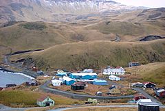
Atka (which is Atx̂ax̂ in the Aleut language and Атка in Russian) is a small city. It is found on the east side of Atka Island in Alaska, United States. Atka is part of the Aleutians West Census Area.
In 2020, about 53 people lived there. Most people in Atka are Aleut, also known as Unangan. The main job for people in Atka is fishing.
Contents
Geography of Atka: Location and Land
Atka is located at 52 degrees North and 174 degrees West. This means it's pretty far north and west on the globe!
Land and Water Area
The city covers a total area of about 36 square miles (94 square kilometers). Most of this area, about 27 square miles (72 square kilometers), is water. The land part is much smaller, only about 8.7 square miles (21.9 square kilometers).
Volcanoes Near Atka
Atka is built on a type of volcano called a shield volcano. This kind of volcano has gentle slopes, like a warrior's shield lying on the ground. It has several openings where lava can come out. The highest point on Atka is Korovin Volcano, which last erupted in 2006.
People of Atka: Population Changes
| Historical population | |||
|---|---|---|---|
| Census | Pop. | %± | |
| 1880 | 236 | — | |
| 1890 | 132 | −44.1% | |
| 1920 | 56 | — | |
| 1930 | 103 | 83.9% | |
| 1940 | 89 | −13.6% | |
| 1950 | 85 | −4.5% | |
| 1960 | 119 | 40.0% | |
| 1970 | 88 | −26.1% | |
| 1980 | 93 | 5.7% | |
| 1990 | 73 | −21.5% | |
| 2000 | 92 | 26.0% | |
| 2010 | 61 | −33.7% | |
| 2020 | 53 | −13.1% | |
| U.S. Decennial Census | |||
Atka has been counted in the U.S. Census for a long time. In 1880, it was first listed as "Nazan" and had 236 residents. Most of these people were Aleut.
How Atka Grew as a City
By 1890, it was called Atka and had 132 residents. It became a special "census-designated place" in 1980. This means it's an area that the census bureau counts as a community, even if it's not officially a city. Then, in 1988, Atka officially became an incorporated city.
Who Lives in Atka Today?
In 2000, there were 92 people living in Atka. Most of the people were Native American (Aleut). Some people were White, Asian, or Pacific Islander, and some were from two or more backgrounds.
Many households in Atka have children. The average household had about 2 to 3 people. The average family had about 3 people.
Age Groups in Atka
The people in Atka are spread across different age groups. About 30% of the population was under 18 years old. About 29% were between 25 and 44 years old. The median age was 36 years old. This means half the people were younger than 36, and half were older.
Getting Around Atka
The only way to fly to Atka Island is through Atka Airport. It's the only airport on the island.
Education in Atka: Yakov E. Netsvetov School
Atka is part of the Aleutian Region Schools system. The main school in Atka is the Yakov E. Netsvetov School. This school teaches students from kindergarten all the way to 12th grade.
Learning at Yakov E. Netsvetov School
The school has two teachers. One teacher teaches the younger students (elementary grades), and the other teaches the older students (secondary grades). In the 2019–2020 school year, there were 10 students enrolled at the school.
See also
 In Spanish: Atka (Alaska) para niños
 | Bayard Rustin |
 | Jeannette Carter |
 | Jeremiah A. Brown |


