Atmore, Alabama facts for kids
Quick facts for kids
Atmore, Alabama
|
|||
|---|---|---|---|
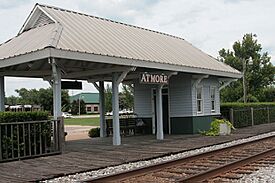
Former Atmore Amtrak station
|
|||
|
|||
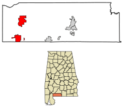
Location of Atmore in Escambia County, Alabama
|
|||
| Country | United States | ||
| State | Alabama | ||
| County | Escambia | ||
| Incorporated | May 9, 1907 | ||
| Area | |||
| • City | 21.937 sq mi (56.816 km2) | ||
| • Land | 21.862 sq mi (56.622 km2) | ||
| • Water | 0.075 sq mi (0.194 km2) | ||
| Elevation | 282 ft (86 m) | ||
| Population
(2020)
|
|||
| • City | 8,391 | ||
| • Estimate
(2022)
|
8,330 | ||
| • Density | 381.00/sq mi (147.10/km2) | ||
| • Urban | 6,390 | ||
| • Metro | 36,666 | ||
| Time zone | UTC−6 (Central (CST)) | ||
| • Summer (DST) | UTC−5 (CDT) | ||
| ZIP Codes |
36502, 36504
|
||
| Area code(s) | 251 | ||
| FIPS code | 01-03004 | ||
| GNIS feature ID | 0113272 | ||
| Sales tax | 10.0% | ||
Atmore is a city in Escambia County, Alabama, United States. In 2020, about 8,391 people lived there. The city was officially started on May 9, 1907.
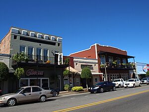
The Atmore Commercial Historic District is a special area in Atmore. It is listed on the National Register of Historic Places. This means it has important historical buildings.
The main office for the Poarch Band of Creek Indians is also in Atmore.
Contents
History of Atmore
Atmore was first known as Williams Station. It was a stop on the Mobile and Great Northern Railroad. The town was going to be called "Carney." This was to honor a man named Mr. Carney who owned a sawmill there.
But Mr. Carney's brother had already named a nearby town "Carney." So, Mr. Carney was allowed to name the town after his friend, C.P. Atmore. Mr. Atmore was a general agent for the Louisville and Nashville Railroad. He never actually visited the town named after him.
In 2008, the city of Atmore grew bigger. It added land that included two state prison properties. The state asked the city to include this land.
Geography of Atmore
Atmore is located in southern Alabama. Its southern border is right next to the state of Florida. A newer part of the city was added about 6 miles (10 km) north.
Mobile is about 51 miles (82 km) southwest of Atmore. Pensacola, Florida, is about 49 miles (79 km) south.
The United States Census Bureau says Atmore covers about 21.9 square miles (56.8 square kilometers). Most of this area is land, with a small amount of water.
Atmore's Climate
Atmore has a climate with mild to high temperatures. Rain falls pretty evenly throughout the year. This type of weather is called a "Humid Subtropical Climate." It means the area has hot, humid summers and mild winters.
| Climate data for Atmore, Alabama, 1991–2020 normals, extremes 1940–present | |||||||||||||
|---|---|---|---|---|---|---|---|---|---|---|---|---|---|
| Month | Jan | Feb | Mar | Apr | May | Jun | Jul | Aug | Sep | Oct | Nov | Dec | Year |
| Record high °F (°C) | 84 (29) |
86 (30) |
90 (32) |
95 (35) |
101 (38) |
104 (40) |
105 (41) |
104 (40) |
102 (39) |
99 (37) |
90 (32) |
85 (29) |
105 (41) |
| Mean maximum °F (°C) | 75.3 (24.1) |
77.4 (25.2) |
83.5 (28.6) |
86.8 (30.4) |
92.7 (33.7) |
96.2 (35.7) |
97.3 (36.3) |
97.0 (36.1) |
94.2 (34.6) |
89.1 (31.7) |
81.9 (27.7) |
77.2 (25.1) |
98.3 (36.8) |
| Mean daily maximum °F (°C) | 60.6 (15.9) |
65.1 (18.4) |
72.2 (22.3) |
78.7 (25.9) |
86.2 (30.1) |
90.9 (32.7) |
92.4 (33.6) |
92.1 (33.4) |
88.5 (31.4) |
80.3 (26.8) |
70.2 (21.2) |
63.0 (17.2) |
78.4 (25.7) |
| Daily mean °F (°C) | 49.8 (9.9) |
53.8 (12.1) |
60.4 (15.8) |
66.8 (19.3) |
74.8 (23.8) |
80.8 (27.1) |
82.7 (28.2) |
82.3 (27.9) |
78.3 (25.7) |
68.7 (20.4) |
58.4 (14.7) |
52.3 (11.3) |
67.4 (19.7) |
| Mean daily minimum °F (°C) | 39.1 (3.9) |
42.5 (5.8) |
48.6 (9.2) |
54.9 (12.7) |
63.5 (17.5) |
70.7 (21.5) |
73.0 (22.8) |
72.5 (22.5) |
68.1 (20.1) |
57.1 (13.9) |
46.7 (8.2) |
41.6 (5.3) |
56.5 (13.6) |
| Mean minimum °F (°C) | 21.4 (−5.9) |
25.7 (−3.5) |
30.5 (−0.8) |
39.0 (3.9) |
49.1 (9.5) |
61.6 (16.4) |
67.2 (19.6) |
65.4 (18.6) |
55.5 (13.1) |
40.1 (4.5) |
29.8 (−1.2) |
26.0 (−3.3) |
19.9 (−6.7) |
| Record low °F (°C) | 1 (−17) |
10 (−12) |
21 (−6) |
29 (−2) |
41 (5) |
49 (9) |
55 (13) |
56 (13) |
42 (6) |
30 (−1) |
17 (−8) |
6 (−14) |
1 (−17) |
| Average precipitation inches (mm) | 5.97 (152) |
4.82 (122) |
5.41 (137) |
4.84 (123) |
5.09 (129) |
6.00 (152) |
6.94 (176) |
5.56 (141) |
5.43 (138) |
3.60 (91) |
4.60 (117) |
5.38 (137) |
63.64 (1,615) |
| Average snowfall inches (cm) | 0.0 (0.0) |
0.0 (0.0) |
0.1 (0.25) |
0.0 (0.0) |
0.0 (0.0) |
0.0 (0.0) |
0.0 (0.0) |
0.0 (0.0) |
0.0 (0.0) |
0.0 (0.0) |
0.0 (0.0) |
0.0 (0.0) |
0.1 (0.25) |
| Average precipitation days (≥ 0.01 in) | 10.4 | 8.6 | 8.8 | 7.6 | 8.7 | 11.6 | 13.5 | 12.1 | 8.5 | 5.8 | 7.3 | 9.6 | 112.5 |
| Average snowy days (≥ 0.1 in) | 0.0 | 0.0 | 0.0 | 0.0 | 0.0 | 0.0 | 0.0 | 0.0 | 0.0 | 0.0 | 0.0 | 0.0 | 0.0 |
| Source 1: NOAA | |||||||||||||
| Source 2: National Weather Service | |||||||||||||
People in Atmore (Demographics)
| Historical population | |||
|---|---|---|---|
| Census | Pop. | %± | |
| 1910 | 1,060 | — | |
| 1920 | 1,775 | 67.5% | |
| 1930 | 3,035 | 71.0% | |
| 1940 | 3,200 | 5.4% | |
| 1950 | 5,720 | 78.8% | |
| 1960 | 8,173 | 42.9% | |
| 1970 | 8,293 | 1.5% | |
| 1980 | 8,789 | 6.0% | |
| 1990 | 8,046 | −8.5% | |
| 2000 | 7,676 | −4.6% | |
| 2010 | 10,194 | 32.8% | |
| 2020 | 8,391 | −17.7% | |
| 2022 (est.) | 8,330 | −18.3% | |
| U.S. Decennial Census 2020 Census |
|||
Atmore first appeared in the U.S. Census in 1910. By 1930, it was the biggest city in Escambia County. It lost that title briefly in 1940 but became the largest city again in 1950. It has stayed the largest city since then. In 2010, the city's population became mostly Black for the first time.
2020 Census Information
| Race | Number | Percent |
|---|---|---|
| White (non-Hispanic) | 3,177 | 37.86% |
| Black or African American (non-Hispanic) | 4,551 | 54.24% |
| Native American | 183 | 2.18% |
| Asian | 32 | 0.38% |
| Pacific Islander | 5 | 0.06% |
| Other/Mixed | 290 | 3.46% |
| Hispanic or Latino | 153 | 1.82% |
In 2020, there were 13,365 people living in the city. There were 2,803 households and 1,443 families.
2010 Census Information
In 2010, Atmore had 10,194 people. The population density was about 1,228 people per square mile. There were 3,480 homes.
The people living in Atmore were made up of different groups. About 55.4% were Black or African American. About 39.3% were White. Other groups included Native American, Asian, and Pacific Islander people. About 1.8% of the population was Hispanic or Latino.
There were 3,002 households. About 26.1% of these had children under 18. Many households were married couples. Others were single parents or individuals living alone. The average household had 2.43 people.
The population's age was spread out. About 18.6% were under 18. About 12.9% were 65 or older. The average age was 37.4 years.
Economy of Atmore
For most of the 1900s, Atmore's economy was based on farming, timber, and small factories. Some major companies included Masland Carpets and Alto. A local lumber company was also important. For many years, the Vanity Fair company had a factory in Atmore. It made lingerie and gave jobs to many local people.
The Poarch Band of Creek Indians has greatly helped the local economy. They operate the Wind Creek Casino and Hotel near Atmore.
Holman Correctional Facility and Fountain Correctional Facility are located north of the city. These facilities provide jobs in the area.
Arts and Culture in Atmore
Atmore has several fun local events throughout the year:
- Mayfest: This event in May has sports, arts and crafts, food, and entertainment.
- Old-Time Fiddlers' Convention: A music competition for fiddlers.
- A Taste of the South: An annual event with entertainment and local food.
- Williams Station Day: This celebration remembers Atmore's history, starting in 1866 as Williams Station. It includes arts, crafts, fiddlers, a model train show, and a sugar cane mill.
- Poarch Creek Indian Pow-wow: An annual event around Thanksgiving. It features traditional foods like turkey and roasted corn, plus a dance competition.
Parks and Recreation in Atmore
Atmore offers places for sports and fun activities. One popular spot is Atmore Heritage Park.
Education in Atmore
The public schools in Atmore are part of the Escambia County Public School System. Schools in the city include:
- Rachel Patterson Elementary School
- Escambia County Middle School (the largest school in the system)
- Escambia County High School (the first public county high school in Alabama)
There are also private schools like Atmore Christian School and Reid State.
Before 1970, African-American children attended separate schools. One example was the Escambia County Training School in Atmore.
A branch campus of Coastal Alabama Community College Brewton is also located here. It offers two-year degrees and training for different jobs.
Transportation in Atmore
Roads and Highways
US Highway 31 and Alabama Highway 21 both pass through Atmore. These are important roads for travel.
Airport
The Atmore Municipal Airport has a runway that is about 4,952 feet (1,509 meters) long.
Railroads
Two freight railroads serve the town: the Alabama and Gulf Coast Railway and CSX. In the past, Atmore had passenger train service. Trains like the Sunnyland and the Azalean used to stop at the Atmore station. Amtrak's Gulf Breeze train also served Atmore until 1995.
Local Bus Service
The Escambia County Alabama Transit System provides bus service throughout Atmore and the county. This is a "dial-a-ride" service, meaning you can call to arrange a ride.
Notable People from Atmore
- Paul Birch, actor, born in Atmore
- Bobby Brantley, former Lieutenant Governor of Florida
- Marva Collins, American educator
- Paul Crawford, jazz musician and historian
- Glenn L. Emmons, former commissioner of the Bureau of Indian Affairs
- Evander Holyfield, four-time world heavyweight boxing champion, born in Atmore
- William C. Maxwell, who Maxwell Air Force Base is named after
- Don McNeal, former NFL football player
- Ron Middleton, former NFL tight end
- Woodrow McClain Parker, professor and author
- Michael Williams, NFL player
- Art White, professional wrestler and football player
See also
 In Spanish: Atmore para niños


