
Attabad Lake facts for kids
Quick facts for kids Attabad Lake |
|
|---|---|

The lake was formed by a landslide in January 2010
|
|
| Location | Attabad, Hunza, Pakistan |
| Primary inflows | Hunza River, 2800 cu ft/sec (26 May 2010) |
| Primary outflows | Hunza River overflowing landslide dam, 3700 cu ft/sec (4 June 2010) |
| Basin countries | Pakistan |
| Max. length | 13 miles (21 km) |
| Max. depth | 358 feet (109 m) |
| Water volume | 0.33 million acre feet (26 May 2010) |

Attabad Lake, sometimes called Gojal Lake, is a beautiful lake in the Hunza Valley in northern Pakistan. It's quite unique because it wasn't always there! This lake was formed naturally by a huge landslide that happened on January 4, 2010.
The landslide occurred in the small village of Attabad. Sadly, twenty people lost their lives in this event. The massive amount of earth and rocks blocked the flow of the Hunza River for about five months.
Contents
How Attabad Lake Was Formed
The landslide created a natural dam across the Hunza River. This blockage caused the river water to build up behind it. Over time, this pooling water formed the large lake we now know as Attabad Lake.
The Impact of the Landslide and Lake
The rising water from the new lake caused a lot of problems for local communities.
- The Karakoram Highway, a major road connecting Pakistan and China, was covered by the floodwaters.
- About 6,000 people living in villages upstream had to move from their homes.
- Another 25,000 people were stuck because the roads were blocked.
- More than 12 miles (19 km) of the Karakoram Highway went underwater.
By early June 2010, the new lake had grown quite large. It was about 13 miles (21 km) long and over 330 feet (100 m) deep. The water eventually started flowing over the top of the landslide dam. This caused even more flooding downstream.
Villages Affected by the Flooding
The flooding submerged parts of villages like lower Shishkat and Gulmit. The area known as Gojal was hit the hardest.
- Over 170 houses were flooded.
- About 120 shops were also submerged.
- People living in these areas faced shortages of food and other important supplies. This was because the main road, the Karakoram Highway, was blocked.
By June 4, 2010, the water flowing out of the lake had increased. It reached about 3,700 cu ft per second.
Images for kids
-
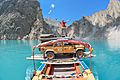
The lake submerged the local highway, and all traffic had to be shipped on barges until a new road tunnel was opened for traffic in September 2015.
-
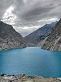
Lake Attabad near Gilgit, Pakistan.


See also
 In Spanish: Lago Attabad para niños
