Aubrey Valley facts for kids
Quick facts for kids Aubrey Valley |
|
|---|---|

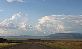
south valley, view north, Aubrey Cliffs at east
|
|
| Length | 35 mi (56 km) |
| Geography | |
| Country | United States |
| State | Arizona |
| Regions | Coconino Plateau and Aubrey Cliffs |
| Counties | Coconino and Yavapai |
| Communities |
List
|
| Borders on |
List
|
Aubrey Valley is a long valley in Arizona, about 35 miles (56 km) from end to end. It's located in the southwest part of Coconino County, right next to Yavapai County.
This valley sits at the edge of the Aubrey Cliffs. These cliffs are like a giant step in the land, marking the southwest border of the Coconino Plateau. The Coconino Plateau is a high, flat area that's part of the much larger Colorado Plateau.
Deep underground, a huge crack in the Earth's crust called the Toroweap Fault runs through the middle of Aubrey Valley. This fault continues all the way to the Colorado River near the Grand Canyon. Another famous fault, the Hurricane Fault, also starts nearby.
The southern part of Aubrey Valley was once home to the famous historic U.S. Route 66. Today, a modern highway, Interstate 40, has taken its place.
One of the most exciting things about Aubrey Valley is that it's a special home for black-footed ferrets. These animals are endangered, meaning they are at risk of disappearing forever. In 1996, scientists brought ferrets back to the valley because it has lots of prairie dogs, which are the ferrets' main food, and perfect grasslands for them to live in.
Exploring Aubrey Valley
Getting around Aubrey Valley is an adventure! The southern part of the valley is crossed by Arizona State Route 66. This road used to be part of the famous U.S. Route 66.
Roads and Routes
Route 66 starts near Seligman, Arizona, which is also close to Interstate 40. From Seligman, the road goes northeast across the southern end of the valley to a place called Grand Canyon Caverns. Then, it turns mostly west across an area known as the Yampai Divide. It continues until it reaches Peach Springs, Arizona, where the land starts to get hilly and mountainous.
In the middle of Aubrey Valley, there are two dirt roads that branch off from Arizona Route 66. These roads head north, one on the west side and one on the east side of a central stream bed. They connect to Reservation Route 20, which is part of the Hualapai Reservation.
A paved road, Reservation Route 18, goes through the northwest part of the valley near the foothills. It passes a mountain called Blue Mountain, which is about 6,038 feet (1,840 meters) tall. This road then goes northeast through a hilly area called Robbers Roost, Arizona. Finally, it meets another part of Reservation Route 18 at Frazier Wells, Arizona. This is the northern end of Aubrey Valley, where the valley gets narrower between the Aubrey Cliffs on the east and hills on the west.
 | William Lucy |
 | Charles Hayes |
 | Cleveland Robinson |


