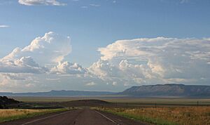
Aubrey Cliffs facts for kids
The Aubrey Cliffs are a long line of tall rock formations, like a giant staircase, found in northwestern Arizona. They are located in Coconino County. These cliffs are a striking natural feature in the desert landscape.
Contents
About the Aubrey Cliffs
How the Cliffs Formed
The Aubrey Cliffs were created by a large crack in the Earth's crust called the Toroweap Fault. This fault runs along the western side of the Aubrey Valley. The cliffs are part of the southwestern edge of the Coconino Plateau.
The Toroweap Fault is connected to another large crack called the Hurricane Fault. These two faults meet near the Colorado River in the western part of the Grand Canyon. Both faults continue north into southern Utah.
Where Are They Located?
The Aubrey Cliffs start near Route 66, about five miles west of a town called Seligman. They stretch generally north all the way to the Colorado River in the Grand Canyon.
The southern part of the cliffs is the most noticeable. It looks over the Aubrey Valley to the west. This section rises about 1,000 feet (300 meters) above the valley floor. The top of the cliffs here is about 6,300 feet (1,900 meters) high.
This southern area is on the Big Boquillas Ranch. This ranch includes land owned by the state and land owned by the Navajo Nation, a Native American tribe.
The northern part of the cliffs overlooks Prospect Valley. This area is located on the Hualapai Indian Reservation, which is land belonging to the Hualapai Native American tribe.
Future Plans for the Cliffs
The southern part of the Aubrey Cliffs might become the home of a large wind farm. A wind farm is a place with many wind turbines that use wind to create electricity. This project is being planned by the Navajo Nation. It is expected to produce 85 megawatts of power.
 | May Edward Chinn |
 | Rebecca Cole |
 | Alexa Canady |
 | Dorothy Lavinia Brown |


