Avard, Oklahoma facts for kids
Quick facts for kids
Avard, Oklahoma
|
|
|---|---|

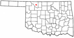
Location of Avard, Oklahoma
|
|
| Country | United States |
| State | Oklahoma |
| County | Woods |
| Area | |
| • Total | 0.10 sq mi (0.27 km2) |
| • Land | 0.10 sq mi (0.27 km2) |
| • Water | 0.00 sq mi (0.00 km2) |
| Elevation | 1,476 ft (450 m) |
| Population
(2020)
|
|
| • Total | 11 |
| • Density | 104.76/sq mi (40.62/km2) |
| Time zone | UTC-6 (Central (CST)) |
| • Summer (DST) | UTC-5 (CDT) |
| FIPS code | 40-03550 |
| GNIS feature ID | 1089768 |
Avard is a small community in Woods County, Oklahoma, United States. It is located southwest of Alva and northeast of Waynoka. In the year 2000, 26 people lived there.
Avard started to grow, but then its population began to shrink in the 1930s. It had a post office from 1895 until 1963. By the 2010 census, Avard was no longer officially a town, but it is still recognized as a special area by the census.
Contents
Avard's Early Days: A Look at Its History
The first post office in Avard opened in 1895. The community officially became a town in 1904. This happened when the Frisco train tracks were extended. They connected with the Santa Fe tracks. The town was named after Isabell Avard Todd. She was the wife of Robert Todd.
How Avard Grew as a Rail Hub
Avard was an important stop for trains. It was served by the Southern Arkansas Railway (Santa Fe) and the Arkansas Valley and Western Railroad (Frisco). This made it a key place for moving goods and people. From 1910 to 1930, it was a major transfer point.
Life in Avard: Businesses and Community
In its busy days, Avard had many businesses. There were general stores, two hotels, and a bank. It also had a livestock auction and a grain elevator. A local newspaper, the Avard Tribune, was published weekly from 1904 to 1918. Avard was also a big center for shipping cattle.
In 1909, about 250 people lived in the town.
Challenges and Changes: Why Avard Shrank
Avard continued to grow until the mid-1930s. Then, the town began to decline. This was due to several big challenges. The Great Depression caused economic hardship. Severe dust storms also hit the area. Farms became larger, meaning fewer people were needed to work them. People also started traveling more by car, reducing the need for train travel.
On top of this, tornadoes struck Avard in both 1943 and 1944. These events further impacted the community.
Avard Today: What Remains
Today, only a few things are still active in Avard. There is a grain elevator and a church. You can also see some old, unused store buildings.
However, the area still has important train connections. The BNSF Railway has its Avard Subdivision here. This rail line runs from Avard all the way to Tulsa. There is also the Avard Regional Industrial Rail Park. This park is ready for new businesses that need train access.
Where is Avard? Understanding Its Geography
Avard is located at 36°41′57″N 98°47′24″W / 36.69917°N 98.79000°W. This means it's at 36.699116 degrees North latitude and -98.790078 degrees West longitude.
The United States Census Bureau says that Avard covers a total area of about 0.2 square miles (0.52 square kilometers). All of this area is land.
Population Changes: A Look at Avard's Numbers
| Historical population | |||
|---|---|---|---|
| Census | Pop. | %± | |
| 1910 | 170 | — | |
| 1920 | 147 | −13.5% | |
| 1930 | 212 | 44.2% | |
| 1940 | 126 | −40.6% | |
| 1950 | 96 | −23.8% | |
| 1960 | 56 | −41.7% | |
| 1970 | 59 | 5.4% | |
| 1980 | 51 | −13.6% | |
| 1990 | 37 | −27.5% | |
| 2000 | 26 | −29.7% | |
| 2020 | 11 | — | |
| U.S. Decennial Census | |||
In the year 2000, there were 26 people living in Avard. These people lived in 13 households, with 6 of them being families. The population density was about 126.7 people per square mile.
About 30.8% of households had children under 18. Nearly half (46.2%) were married couples. The average household had 2 people, and the average family had 3 people.
The population was spread out by age:
- 19.2% were under 18
- 7.7% were 18 to 24
- 26.9% were 25 to 44
- 26.9% were 45 to 64
- 19.2% were 65 or older
The median age was 42 years. For every 100 females, there were about 116.7 males.
The median income for a household was $23,750. For families, it was $40,000. The average income per person was $11,757.
 | Emma Amos |
 | Edward Mitchell Bannister |
 | Larry D. Alexander |
 | Ernie Barnes |

