Ayr, Nebraska facts for kids
Quick facts for kids
Ayr, Nebraska
|
|
|---|---|
|
Village
|
|

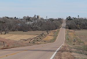
Ayr, as seen from the west along
Nebraska Highway 74, November 2012 |
|

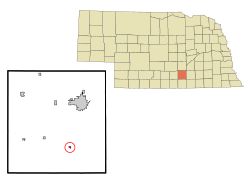
Location of Ayr, Nebraska
|
|
| Country | United States |
| State | Nebraska |
| County | Adams |
| Area | |
| • Total | 0.24 sq mi (0.63 km2) |
| • Land | 0.24 sq mi (0.63 km2) |
| • Water | 0.00 sq mi (0.00 km2) |
| Elevation | 1,831 ft (558 m) |
| Population
(2020)
|
|
| • Total | 83 |
| • Density | 342.98/sq mi (132.27/km2) |
| Time zone | UTC-6 (Central (CST)) |
| • Summer (DST) | UTC-5 (CDT) |
| ZIP code |
68925
|
| Area code(s) | 402 |
| FIPS code | 31-02865 |
| GNIS feature ID | 2398015 |
Ayr is a small village located in Adams County, Nebraska, in the United States. In 2010, about 94 people lived there. It is part of the wider Hastings, Nebraska area, which is called the Hastings Micropolitan Statistical Area.
Contents
History of Ayr
Ayr started in 1878 when a railroad was built through the area. It was named after Doctor Ayr, a railroad official from Iowa. Ayr officially became a village in 1883.
Geography and Climate
Ayr is a small village. It covers about 0.18 square miles (0.47 km2) of land, with no water areas.
Ayr's Weather
The weather in Ayr, Nebraska, changes throughout the year. Here is a summary of the climate:
| Climate data for Ayr, Nebraska (coordinates:40°28′47″N 98°24′09″W / 40.4798°N 98.4026°W, 1991-2020) | |||||||||||||
|---|---|---|---|---|---|---|---|---|---|---|---|---|---|
| Month | Jan | Feb | Mar | Apr | May | Jun | Jul | Aug | Sep | Oct | Nov | Dec | Year |
| Average precipitation inches (mm) | 0.55 (14) |
0.82 (21) |
1.43 (36) |
2.68 (68) |
5.46 (139) |
4.20 (107) |
3.30 (84) |
3.45 (88) |
2.14 (54) |
2.02 (51) |
1.13 (29) |
0.91 (23) |
28.09 (714) |
| Average precipitation days (≥ 0.01 in) | 3.4 | 4.2 | 6.4 | 8.4 | 10.3 | 9.5 | 7.5 | 8.5 | 6.9 | 6.7 | 3.4 | 5 | 80.2 |
| Source: NOAA | |||||||||||||
Population Facts
The number of people living in Ayr has changed over the years. Here's a look at the population from different census counts:
| Historical population | |||
|---|---|---|---|
| Census | Pop. | %± | |
| 1880 | 128 | — | |
| 1890 | 173 | 35.2% | |
| 1900 | 141 | −18.5% | |
| 1910 | 142 | 0.7% | |
| 1920 | 164 | 15.5% | |
| 1930 | 177 | 7.9% | |
| 1940 | 152 | −14.1% | |
| 1950 | 121 | −20.4% | |
| 1960 | 111 | −8.3% | |
| 1970 | 140 | 26.1% | |
| 1980 | 112 | −20.0% | |
| 1990 | 101 | −9.8% | |
| 2000 | 98 | −3.0% | |
| 2010 | 94 | −4.1% | |
| 2020 | 83 | −11.7% | |
| U.S. Decennial Census | |||
Ayr's Population in 2010
In 2010, the census showed that 94 people lived in Ayr. There were 35 households and 26 families. The village had about 522.2 inhabitants per square mile (201.6/km2) people per square mile. All residents were White.
About 34% of the households had children under 18 living with them. Most households (65.7%) were married couples. The average household had about 2.69 people. The average age of people in the village was 43.5 years old. About 28.7% of residents were under 18, and 13.8% were 65 or older. The number of males and females was about equal.
See also

- In Spanish: Ayr (Nebraska) para niños
 | Calvin Brent |
 | Walter T. Bailey |
 | Martha Cassell Thompson |
 | Alberta Jeannette Cassell |

