Baffle Creek facts for kids
Quick facts for kids Baffle |
|
|---|---|
|
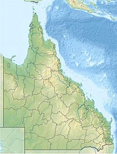
Location of Baffle Creek river mouth in Queensland
|
|
| Country | Australia |
| State | Queensland |
| Region | Central Queensland |
| Physical characteristics | |
| Main source | Great Dividing Range Arthurs Seat 282 m (925 ft) 24°11′13″S 151°38′22″E / 24.18694°S 151.63944°E |
| River mouth | Mouth of Baffle Creek Conservation Park Coral Sea, Australia 0 m (0 ft) 24°29′55″S 152°03′04″E / 24.49861°S 152.05111°E |
| Length | 124 km (77 mi) |
| Basin features | |
| Basin size | 4,084 km2 (1,577 sq mi) |
| Tributaries |
|
| Islands | Grants Island; Long Island |
The Baffle Creek is a cool creek located in Central Queensland, Australia. It's an important waterway known for its natural beauty and unique features.
Contents
Journey of Baffle Creek
Where the Creek Begins
The Baffle Creek starts its journey high up near a place called Arthurs Seat. This spot is found within the Eurimbula State Forest. It's also just south of the Eurimbula National Park. This area is part of the famous Great Dividing Range.
How the Creek Flows
The creek stretches for about 124-kilometre (77 mi) (that's about 77 miles!). It first flows towards the south. On its way, it has hills on both sides. The Westwood Range is to its west, and Mount Dromedary is to its east.
The creek then crosses the Bruce Highway near Miriam Vale. After this, it turns southeast. Here, the creek forms what are called braided channels. This means the water splits into many smaller streams that weave together. It's like many tiny rivers flowing side-by-side!
Islands and the Sea
As it flows, the Gwynne Range is to its east. This helps create an island called Grants Island. The creek crosses the Bruce Highway again. Then it flows east, passing Mount Maria.
Finally, the Baffle Creek turns north. It flows through the Mouth of Baffle Creek Conservation Park. It then empties into the Coral Sea. This happens south of Rules Beach and northeast of Winfield. At its mouth, the creek forms another braided channel around Long Island.
Creek's Home Area
The entire area that collects water for Baffle Creek is called its catchment area. This area is huge, covering about 4,084 square kilometres (1,577 sq mi). A part of this area, about 134 square kilometres (52 sq mi), is made up of estuarine wetlands. These wetlands are special places where fresh river water mixes with salty ocean water. They are super important homes for many plants and animals.
How Baffle Creek Got Its Name
The name "Baffle Creek" has an interesting story! It was named in the 1850s. A man named William Henry Walsh gave it this name. He was a pastoralist, which means he managed large farms with animals. He was also a politician, someone involved in government.
Walsh was on an expedition when he came across the creek. His group was trying to follow some tracks. But the tracks disappeared into the very thick bush along the creek banks. It was so dense that they couldn't follow them anymore! This situation was very confusing or "baffling" to them. Because they were so puzzled, Walsh decided to name the creek Baffle Creek.
 | Madam C. J. Walker |
 | Janet Emerson Bashen |
 | Annie Turnbo Malone |
 | Maggie L. Walker |


