
Bagalkote facts for kids
Quick facts for kids
Bagalkot
|
|
|---|---|
|
City
|
|

Reconstructed Shirur Agasi
|
|

Bagalkot
Location in Karnataka
|
|
| Country | |
| State | Karnataka |
| Region | Bayaluseeme |
| District | Bagalkot |
| Government | |
| • Type | City Municipal Council (CMC) |
| • Body | Bagalkot CMC & BTDA |
| Area | |
| • Total | 49.06 km2 (18.94 sq mi) |
| Elevation | 537.06 m (1,762.01 ft) |
| Population
(2011)
|
|
| • Total | 112,090 |
| • Density | 2,183/km2 (5,650/sq mi) |
| Demonym(s) | Bagalkotians |
| Languages | |
| • Official | Kannada |
| Time zone | UTC+5:30 (IST) |
| PIN |
587101-103
|
| Telephone code | 08354 |
| Vehicle registration | KA-29, KA-48 |
Bagalkot is a city in the state of Karnataka, India. It is the main city and headquarters of the Bagalkot district. The city is located near a branch of the Ghataprabha River. It is about 481 kilometers (299 miles) northwest of Bengaluru, the capital city of Karnataka. In 2011, the city had a population of over 111,000 people.
Contents
History of Bagalkot
How the City Got Its Name
According to old stone writings found nearby, the town was once called Bagadige. A local story says that Ravana, a powerful king from ancient times, gave this town to musicians. Another story tells that Ibrahim Adil Shah II, a king from the Bijapur Adil Shahi family, gave the town to his daughter. This gift was known as bangle money, a tradition where parents give money to their daughter after marriage.
Who Ruled Bagalkot?
Over many years, different groups ruled Bagalkot. It was part of the Vijayanagar Empire for a long time. After that, the Adil Shahi dynasty from Bijapur took control. Then, the Maratha Empire and the Kingdom of Mysore ruled the area. Finally, the British took over Bagalkot in 1818. In 1865, Bagalkot became a municipality, which means it started having its own local government to provide services for its people.
Geography of Bagalkot
Bagalkot is located at about 16.18 degrees North and 75.7 degrees East. The city is about 533 meters (1,749 feet) above sea level. It is built on the banks of the Ghataprabha River.
People and Languages
Population and Education
In 2011, Bagalkot had a population of 111,933 people. For every 1,000 males, there were 985 females, which is called the sex ratio. The city has a high literacy rate of 85.40%, meaning most people can read and write. About 10.33% of the population belonged to Scheduled Castes, and 3.78% belonged to Scheduled Tribes. These are groups of people recognized by the Indian government.
Religions and Languages Spoken
| Religions in Bagalkot city (2011) | ||||
|---|---|---|---|---|
| Religion | Percent | |||
| Hinduism | 72.87% | |||
| Islam | 25.52% | |||
| Jainism | 0.58% | |||
| Others† | 1.03% | |||
| Distribution of religions | ||||
Most people in Bagalkot follow Hinduism, while a significant number follow Islam. Other religions like Jainism are also present.
The main language spoken in Bagalkot is Kannada, which is the official language of Karnataka. Many people also speak Urdu, Marathi, and Hindi as their first language.
Climate in Bagalkot
Bagalkot has a climate that changes throughout the year. It can get quite hot, especially in the summer months like April and May. The city also experiences a monsoon season, which brings a lot of rain, especially from June to October. The coolest months are usually December and January.
| Climate data for Bagalkote, elevation 524 m (1,719 ft), (1991–2020 normals, extremes 1985–2018 ) | |||||||||||||
|---|---|---|---|---|---|---|---|---|---|---|---|---|---|
| Month | Jan | Feb | Mar | Apr | May | Jun | Jul | Aug | Sep | Oct | Nov | Dec | Year |
| Record high °C (°F) | 34.1 (93.4) |
37.8 (100.0) |
41.6 (106.9) |
42.0 (107.6) |
46.0 (114.8) |
41.6 (106.9) |
38.0 (100.4) |
36.0 (96.8) |
36.3 (97.3) |
36.8 (98.2) |
37.0 (98.6) |
35.0 (95.0) |
46.0 (114.8) |
| Mean daily maximum °C (°F) | 29.3 (84.7) |
32.0 (89.6) |
35.2 (95.4) |
37.1 (98.8) |
37.6 (99.7) |
32.3 (90.1) |
29.6 (85.3) |
29.2 (84.6) |
29.9 (85.8) |
29.9 (85.8) |
29.4 (84.9) |
28.5 (83.3) |
31.7 (89.1) |
| Mean daily minimum °C (°F) | 14.5 (58.1) |
16.2 (61.2) |
19.5 (67.1) |
22.5 (72.5) |
23.1 (73.6) |
22.2 (72.0) |
21.6 (70.9) |
21.1 (70.0) |
20.8 (69.4) |
20.7 (69.3) |
18.1 (64.6) |
14.7 (58.5) |
19.6 (67.3) |
| Record low °C (°F) | 8.8 (47.8) |
10.0 (50.0) |
13.2 (55.8) |
14.1 (57.4) |
16.1 (61.0) |
14.0 (57.2) |
15.0 (59.0) |
15.3 (59.5) |
13.3 (55.9) |
13.2 (55.8) |
9.6 (49.3) |
8.2 (46.8) |
8.2 (46.8) |
| Average rainfall mm (inches) | 1.6 (0.06) |
1.3 (0.05) |
1.5 (0.06) |
20.4 (0.80) |
45.3 (1.78) |
109.0 (4.29) |
46.8 (1.84) |
77.3 (3.04) |
111.8 (4.40) |
112.6 (4.43) |
18.0 (0.71) |
7.7 (0.30) |
553.3 (21.78) |
| Average rainy days | 0.2 | 0.1 | 0.3 | 1.4 | 3.1 | 5.9 | 4.3 | 5.3 | 6.3 | 5.7 | 1.3 | 0.5 | 34.4 |
| Average relative humidity (%) (at 17:30 IST) | 50 | 43 | 42 | 46 | 47 | 62 | 69 | 68 | 64 | 62 | 55 | 50 | 55 |
| Source: India Meteorological Department | |||||||||||||
Gallery
-
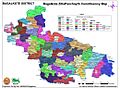
Bagalkot district ZP Constituency Map
-
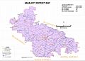
Bagalkot district Map by villages
-
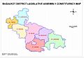
Bagalkot district taluk map
-
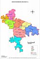
Bagalkot lok sabha map


See also
 In Spanish: Bagalkot para niños
