Bakersfield, Missouri facts for kids
Quick facts for kids
Bakersfield, Missouri
|
|
|---|---|
|
Village
|
|

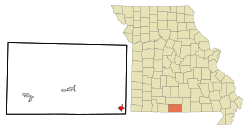
Location of Bakersfield, Missouri
|
|
| Country | United States |
| State | Missouri |
| County | Ozark |
| Area | |
| • Total | 1.37 sq mi (3.55 km2) |
| • Land | 1.37 sq mi (3.55 km2) |
| • Water | 0.00 sq mi (0.00 km2) |
| Elevation | 702 ft (214 m) |
| Population
(2020)
|
|
| • Total | 186 |
| • Density | 135.77/sq mi (52.43/km2) |
| Time zone | UTC-6 (Central (CST)) |
| • Summer (DST) | UTC-5 (CDT) |
| ZIP code |
65609
|
| Area code(s) | 417 |
| FIPS code | 29-03052 |
Bakersfield is a small village located in the southeastern part of Ozark County, in the Ozarks region of southern Missouri, United States. In 2020, about 186 people lived there.
Contents
History of Bakersfield
Bakersfield got its start when a post office opened there in 1873. Before it was officially called Bakersfield, people sometimes called it "Bakersville" or "Waterville." The village was named after a man named Jim Baker, who owned the land where the town was built.
Where is Bakersfield Located?
Bakersfield is in the area known as Bayou I Township. It sits on the west side of Bennetts Bayou. You can find it where two main roads, Missouri routes 101 and 142, meet.
The village is very close to the border between Missouri and Arkansas, only about 1.5 miles north of it. Another town called Caulfield is about seven miles northeast, also along Route 101.
According to the United States Census Bureau, Bakersfield covers a total area of about 1.37 square miles (3.55 square kilometers). All of this area is land, with no water.
People in Bakersfield
The number of people living in Bakersfield has changed over the years. Here's a quick look at the population from different census counts:
| Historical population | |||
|---|---|---|---|
| Census | Pop. | %± | |
| 1930 | 181 | — | |
| 1940 | 177 | −2.2% | |
| 1970 | 210 | — | |
| 1980 | 241 | 14.8% | |
| 1990 | 292 | 21.2% | |
| 2000 | 285 | −2.4% | |
| 2010 | 246 | −13.7% | |
| 2020 | 186 | −24.4% | |
| U.S. Decennial Census | |||
What the 2010 Census Showed
In 2010, the census counted 246 people living in Bakersfield. There were 100 households, which are groups of people living together in one home. Out of these, 59 were families.
Most of the people in the village were White (about 96.75%). A small number were Native American or from other backgrounds. About 1.63% of the population identified as Hispanic or Latino.
Of the 100 households, about 33% had children under 18 living with them. Nearly half (45%) were married couples living together. About 37% of all households were made up of single individuals. Around 19% of homes had someone aged 65 or older living alone.
The average age of people in Bakersfield in 2010 was about 35.8 years old. Roughly 29.3% of residents were under 18. About 17.1% were 65 years old or older. The population was slightly more female (53.3%) than male (46.7%).
See also
 In Spanish: Bakersfield (Misuri) para niños

