Glasgow, Virginia facts for kids
Quick facts for kids
Glasgow, Virginia
|
||
|---|---|---|

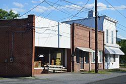
McCullough Street in the historic district
|
||
|
||

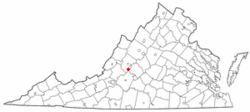
Location of Glasgow, Virginia
|
||
| Country | United States | |
| State | Virginia | |
| County | Rockbridge | |
| Area | ||
| • Total | 1.53 sq mi (3.97 km2) | |
| • Land | 1.53 sq mi (3.95 km2) | |
| • Water | 0.01 sq mi (0.01 km2) | |
| Elevation | 738 ft (225 m) | |
| Population
(2020)
|
||
| • Total | 1,052 | |
| • Density | 689.4/sq mi (266.2/km2) | |
| Time zone | UTC-5 (Eastern (EST)) | |
| • Summer (DST) | UTC-4 (EDT) | |
| ZIP code |
24555
|
|
| Area code(s) | 540 | |
| FIPS code | 51-31136 | |
| GNIS feature ID | 1494956 | |
| Website | Official website: http://www.glasgowvirginia.org/ | |
Glasgow is a small town in Rockbridge County, Virginia, United States. It is located where the James River and Maury River meet. In 2020, about 1,052 people lived there.
Glasgow has faced challenges with flooding many times. A big flood happened during Hurricane Camille in 1969. Because of these flood worries, the Balcony Falls Dam was taken down in 1973. For a few years, from 2001 to 2007, Glasgow was known for having over a dozen fiberglass dinosaur statues along its roads.
Glasgow's History
The first Europeans to settle in the area now known as Glasgow were German explorer John Peter Salling and his brother Adam, around 1741. In December 1742, a battle called the Battle of Galudoghson took place nearby. It was between Iroquois warriors and Virginia militia. The militia captain, John McDowell, and eight soldiers died.
Later, between 1760 and 1768, John Paxton II bought most of the Salling family's land. The Glasgow family, including Robert, Joseph, and Arthur, moved to the area in 1768. The town was named after Joseph Glasgow, Arthur's son. Joseph and his wife, Nancy Ellis McCullough, built their home, called Union Ridge, in 1823.
In 1854, a brave man named Frank Padgett, who was an enslaved person, drowned while trying to save people from a canal boat stuck in the flooded James River. There is a stone monument in Glasgow's Centennial Park that honors his heroic act.
Glasgow officially became a town on March 5, 1890. At that time, only two houses, Union Ridge and the Salling home, stood there, and only 20 people lived in Glasgow. By 1892, the town had modern features like paved roads, streetlights, and telephone service. It even had a large 200-room hotel called the Rockbridge Hotel. However, economic problems in 1893 caused the company that built the town to go out of business. The hotel was left empty and was taken down around 1906.
A company called VEPCO (now Dominion Energy) built a hydroelectric plant at Balcony Falls in 1915. This plant made electricity using water power until 1969. After the terrible flood of 1969, people in Glasgow believed the flood would not have been as bad if the dam wasn't there. So, in 1974, they asked for the dam to be removed. Flooding has been a big issue for Glasgow many times. Major floods happened in 1877, 1936, 1950, 1969, 1972, 1985, and 1995. The floods of 1936, 1969, and 1985 were the worst.
Town Geography
Glasgow is located at 37°37′59″N 79°27′06″W / 37.633093°N 79.451542°W. It is about 6 miles east of Natural Bridge, which is famous for its large, natural land bridge.
The United States Census Bureau says the town covers about 1.5 square miles (4.0 km2), and all of it is land.
Glasgow's Climate
The weather in Glasgow includes hot, humid summers and generally mild to cool winters. It has a humid subtropical climate. On July 15, 1954, the temperature at Balcony Falls reached 110°F (43°C). This is the highest temperature ever recorded in the state of Virginia.
Population Facts
| Historical population | |||
|---|---|---|---|
| Census | Pop. | %± | |
| 1910 | 407 | — | |
| 1920 | 376 | −7.6% | |
| 1930 | 507 | 34.8% | |
| 1940 | 938 | 85.0% | |
| 1950 | 810 | −13.6% | |
| 1960 | 1,091 | 34.7% | |
| 1970 | 1,304 | 19.5% | |
| 1980 | 1,259 | −3.5% | |
| 1990 | 1,140 | −9.5% | |
| 2000 | 1,046 | −8.2% | |
| 2010 | 1,133 | 8.3% | |
| 2020 | 1,052 | −7.1% | |
| U.S. Decennial Census | |||
In 2000, there were 1,046 people living in Glasgow. The town had 450 households. The average household had about 2.32 people.
The population was spread out by age:
- 23.9% were under 18 years old.
- 7.6% were between 18 and 24.
- 25.0% were between 25 and 44.
- 25.3% were between 45 and 64.
- 18.2% were 65 years or older.
The average age in Glasgow was 40 years.
See also
 In Spanish: Glasgow (Virginia) para niños


