
Baldivis, Western Australia facts for kids
Quick facts for kids BaldivisPerth, Western Australia |
|||||||||||||||
|---|---|---|---|---|---|---|---|---|---|---|---|---|---|---|---|

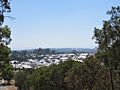
View of a Baldivis housing estate from Tamworth Hill, 2021
|
|||||||||||||||
| Postcode(s) | 6171 | ||||||||||||||
| Area | 87.3 km2 (33.7 sq mi) | ||||||||||||||
| Location |
|
||||||||||||||
| LGA(s) | City of Rockingham | ||||||||||||||
| State electorate(s) | Baldivis, Warnbro | ||||||||||||||
| Federal Division(s) | Brand | ||||||||||||||
|
|||||||||||||||

Baldivis is a growing suburb in Western Australia. It is about 46 kilometers (28 miles) south of Perth, the capital city. It is also 11 kilometers (7 miles) southeast of Rockingham. Baldivis is part of the City of Rockingham area.
Many people from different backgrounds live here. Baldivis has the most speakers of Afrikaans, Māori, and Shona in all of Australia! The suburb has many housing areas. Some of these are Tuart Ridge, Settlers Hills, and The Rivergums.
Contents
The Story Behind Baldivis's Name
The name Baldivis has a special origin. It was created by early settlers who came to the area in the 1920s. They were part of a plan called the Group Settlement Scheme. This plan helped people move to Western Australia.
The name "Baldivis" comes from three ships. These ships brought settlers to Western Australia in 1922. The ships were named BALranald, DIogenes, and JerVIS Bay. All three ships were new and built in the same year. They all arrived within six weeks of each other.
A special tramway was planned for the area. It would have helped people travel between Jandakot and Karnup. This tramway was meant to serve the Group Settlement Scheme. Even though it was never fully built in Baldivis, the land set aside for it is now open space.
You might notice some road names like Sixty Eight Road or Fifty Road. These names come from the group numbers of the original settlers! In the 1990s, the western part of Baldivis began to be developed. This is when many of the homes you see today started to appear. Settlers Hills was one of the first housing estates built.
Exploring Baldivis's Landscape
The land in Baldivis is quite interesting. The western part has sandy hills and limestone soil. It also has some wetlands. The highest point here is Tamworth Hill. This hill is where a water reservoir is located. Most of this area now has houses.
East of Baldivis Road, the land is mostly flat. It has sand and clay soils. One exception is a sandy hill called Dog Hill. These eastern areas are often used for farming or rural activities. You can also find beautiful tuart trees in the western part of Baldivis. Some of these old trees have been kept within the new housing areas.
Getting Around Baldivis
Baldivis has bus services to help people travel. The Transperth bus routes connect the suburb to Warnbro Train Station. This station is a hub for public transport.
Buses like route 564 serve the Baldivis Town Centre. They travel through areas like Settlers Hills and The Ridge. Route 567 connects The Rivergums and Heritage Park. These bus routes run every day, making it easy to get around. They run more often during busy times like school hours.
The Kwinana Freeway passes through Baldivis. This major road helps people drive to Perth in the north and Bunbury in the south. Safety Bay Road is another important road. It links Baldivis to nearby suburbs like Rockingham and Warnbro.
If you like cycling, there's a special path along the Kwinana Freeway. This path allows you to ride your bike all the way to Perth. Some bus routes also act as school buses. They help students get to and from Mother Teresa Catholic College and Ridge View Secondary College.
Fun Places and Facilities
Baldivis has many great facilities for its residents.
- The Fifty Road Recreation Centre and Sporting Grounds is a popular spot. It's home to the Baldivis Brumbies sports teams. It also hosts the Baldivis Scouts and the yearly Baldivis Fair.
- The Mary Davies Library and Community Centre opened in 2014. It's a busy place for clubs, dance groups, and community meetings.
- The Fire & Emergency Services building is located on Eighty Road.
- The Tramway reserve is a protected walking path that runs through Baldivis.
- The Baldivis Children's Forest is a special place for kids to explore nature.
Learning in Baldivis: Schools
Baldivis is home to many schools, with more being planned!
- Baldivis Primary School is a government school. It first opened in 1924 as a "bush school." It moved to its current location in 1978. You can find a plaque marking the original school site on Doghill Road.
- Tranby College is a private school. It opened in 1997 and teaches students from kindergarten to Year 12.
- Settlers Primary School is another government school. It opened in 2005 and is located across from Tranby College.
- John Calvin Primary School is on Mandurah Road.
- Makybe Rise Primary School opened in 2012 in the Tuart Ridge estate.
- Baldivis Secondary College is a public high school. It opened in 2013 and teaches students from Year 7 to Year 12.
- Mother Teresa Catholic College opened in 2014. Its secondary school campus opened in 2018.
- Tuart Rise Primary School opened in 2015 in the Avalon estate.
- Rivergums Primary School opened in 2016. It is next to Baldivis Secondary College.
- Baldivis Gardens Primary School opened in 2017 in the northern part of Baldivis.
- Ridge View Secondary College is a public high school. It opened in 2019.
- Sheoak Grove Primary School opened in 2020.
- Pine View Primary School is a public primary school that opened in 2021 in Parkland Heights.
Shopping and More
The main shopping area in Baldivis is the Baldivis Town Centre. It is on Settlers Avenue. The Baldivis Shopping Centre opened in 2007. It has a Coles supermarket. In 2015, the centre got bigger. It added a food court, more parking, a Kmart, and a Woolworths.
In 2017, another shopping area called Baldivis Square opened. It is next to Makybe Rise Primary School. Baldivis Square has different shops, food places, and offices. It also has an IGA supermarket. The office for Reece Whitby, who is the local Member of Parliament (MLA) for Baldivis, is also in Baldivis Square.
Sports and Recreation

Baldivis has a lively sports scene with several clubs:
- The Baldivis Soccer Club started in 2012. They play at the Baldivis South Sports Pavilion. The club has grown a lot and now has many teams for all ages.
- The Baldivis White Knights Cricket Club (WKBCC) was formed in 2001. They play at Arpenteur Park.
- The Baldivis Brumbies Football Club (BFC) started in 1986. They have many teams and grounds.
- The North Baldivis Cricket Club (NBCC) was formed in 2019.
A new Baldivis Sports Complex opened in March 2023. It has an indoor sports area and outdoor cricket fields. Important people like the Mayor of Rockingham and the Premier of Western Australia attended the opening.
Images for kids
-
View of a Baldivis housing estate from Tamworth Hill, 2021
-
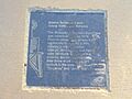
Plaque giving the origin of the name "Baldivis" on the Rockingham Waterfront Pioneer Rotary Walk in Rockingham, Western Australia.
-
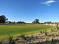
The Baldivis Sports Complex, opened in March 2023
