Banks–Vernonia State Trail facts for kids
Quick facts for kids Banks–Vernonia State Trail |
|
|---|---|

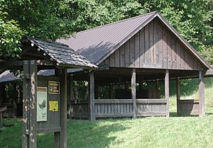
Whistle-stop shelter at the Buxton trailhead
|
|
| Lua error in Module:Location_map at line 420: attempt to index field 'wikibase' (a nil value). | |
| Type | Public, state |
| Location | Columbia and Washington counties, Oregon |
| Nearest city | Between Banks and Vernonia |
| Operated by | Oregon Parks and Recreation Department |
| Open | Year round |
| Status | Day use, fee-free |
The Banks–Vernonia State Trail is a cool paved path in northwest Oregon, United States. It's a special kind of park called a "rail trail" because it follows an old railroad line. This trail is about 21 miles (34 kilometers) long. It stretches mostly north to south between the towns of Vernonia in Columbia County and Banks in Washington County. Banks is about 25 miles (40 kilometers) west of Portland.
Contents
About the Trail
The main path on the Banks–Vernonia State Trail is 8 feet (2.4 meters) wide. It's perfect for activities like hiking and biking. Next to it, there's also a 4-foot (1.2-meter) wide trail just for horses.
The trail crosses 12 bridges. One of the most famous is the Buxton Trestle. A trestle is a tall bridge that carries a path over a valley or obstacle. The Buxton Trestle is 600 feet (180 meters) long and 80 feet (24 meters) high! Another old railroad bridge, the Tophill Trestle, was damaged by fire. Now, you can get around it using a series of zig-zag paths at the Tophill trailhead.
What You Can Do There
Along the trail, you'll find many useful spots. Some areas have picnic tables, places for fishing, and great views for watching wildlife. You can also enjoy the forests and look for different kinds of birds. There are historic sites to explore, public restrooms, and parking areas. For those with horses, there are special hitching posts and a loading platform. You might even see a "whistle stop" shelter, which is like a small waiting area from the old train days.
The Banks–Vernonia State Trail also connects to other trails. You can find about 20 miles (32 kilometers) of unpaved mountain-biking trails in L. L. "Stub" Stewart State Park nearby. Many people enjoy this trail; for example, about 14,000 people visited it in 2004.
Trail History
The Banks–Vernonia State Trail was the very first "linear rail trail" state park in Oregon. This means it's a long, narrow park built on an old railroad line.
How the Trail Was Made
The original railroad line was built in 1913 by the Portland, Astoria, and Pacific Railroad. It was used to move timber, other goods, and even passengers. In the 1920s, trains on this line carried logs and lumber from places like Keasey and a mill in Vernonia to Portland.
The railroad stopped using the line in 1957 because the mills closed. From 1965 to 1969, a different company leased the line for a fun steam excursion train. The line was completely abandoned in 1973.
The Oregon Department of Transportation bought the land in 1974. Then, in 1990, they gave it to the Oregon Parks and Recreation Department. This department turned the old railway into the trail we know today. In 2007, L. L. "Stub" Stewart State Park opened right next to the trail. Improvements to the trail continued for 20 years. They were finished in 2010 when the Banks trailhead opened with a kiosk that looks like an old train station.
Special People Who Helped
Part of the trail near Manning, Oregon, runs through an area called Pihl Road. This road is named after Holger Mathew Pihl Sr. and his wife Alice. They were very important in making the trail happen. They spent many hours clearing brush from the abandoned rail lines. They also donated money to help finish the project when funds ran out. The Pihls even paid for the picnic pavilion at the Buxton Trailhead and named it the "Whistle Stop."
Trail Locations
The Banks–Vernonia State Trail has several important points along its path. These include trailheads where you can start your journey and other notable spots.
| Location | Coordinates | Trail location | Elevation | ||
|---|---|---|---|---|---|
| mi | km | ft | m | ||
| Banks trailhead | 45°37′18.68″N 123°06′49.79″W / 45.6218556°N 123.1138306°W | 0.0 | 0 | 208 | 63 |
| Manning trailhead | 45°39′54.87″N 123°09′48.49″W / 45.6652417°N 123.1634694°W | 3.85 | 6.20 | 239 | 73 |
| Buxton trailhead | 45°41′52.44″N 123°11′07.49″W / 45.6979000°N 123.1854139°W | 6.7 | 10.8 | 459 | 140 |
| Tophill trailhead | 45°45′30.93″N 123°12′05.87″W / 45.7585917°N 123.2016306°W | 12.05 | 19.39 | 807 | 246 |
| Beaver Creek trailhead | 45°48′38.79″N 123°13′49.90″W / 45.8107750°N 123.2305278°W | 16.4 | 26.4 | 684 | 208 |
| Anderson Park (Vernonia) | 45°51′20.93″N 123°11′31.10″W / 45.8558139°N 123.1919722°W | 20.65 | 33.23 | 605 | 184 |


