
Barahona, Morovis, Puerto Rico facts for kids
Quick facts for kids
Barahona
|
|
|---|---|
|
Barrio
|
|

Building in Barahona
|
|

Location of Barahona within the municipality of Morovis shown in red
|
|

Barahona, Morovis, Puerto Rico
Location in Caribbean
|
|
| Commonwealth | |
| Municipality | |
| Area | |
| • Total | 3.76 sq mi (9.7 km2) |
| • Land | 3.76 sq mi (9.7 km2) |
| • Water | 0 sq mi (0 km2) |
| Elevation | 561 ft (171 m) |
| Population
(2010)
|
|
| • Total | 5,244 |
| • Density | 1,398.4/sq mi (539.9/km2) |
| Source: 2010 Census | |
| Time zone | UTC−4 (AST) |
| Zip code |
00687
|
Barahona is a special kind of area called a barrio in the town of Morovis, Puerto Rico. It's like a neighborhood or district. Barahona has thirteen smaller areas called sectors. In 2010, about 5,244 people lived there.
Contents
A Look at Barahona's Past
How Barahona Became Part of the U.S.
Puerto Rico, including Barahona, used to be part of Spain. After the Spanish–American War in 1898, Spain gave Puerto Rico to the United States. This happened under an agreement called the Treaty of Paris of 1898. Puerto Rico then became a territory of the United States.
Counting People in Barahona
In 1899, the United States government counted everyone living in Puerto Rico. They found that 854 people lived in Barahona barrio at that time. Over the years, the number of people living in Barahona has grown quite a bit!
| Historical population | |||
|---|---|---|---|
| Census | Pop. | %± | |
| 1900 | 854 | — | |
| 1980 | 2,914 | — | |
| 1990 | 3,814 | 30.9% | |
| 2000 | 4,410 | 15.6% | |
| 2010 | 5,244 | 18.9% | |
| U.S. Decennial Census 1899 (shown as 1900) 1910-1930 1930-1950 1980-2000 2010 |
|||
Helping After Hurricane Maria
On September 20, 2017, Hurricane Maria hit Puerto Rico very hard. It damaged many important things like roads and water systems. After the hurricane, the Puerto Rico National Guard stepped in. They helped by bringing clean drinking water to people in places like Barahona.
Understanding Barahona's Sectors
What Are Barrios and Sectors?
In Puerto Rico, a "barrio" is like a large neighborhood or district. These barrios are then divided into even smaller areas. These smaller areas are called sectores (which means "sectors" in English). Sectors can have different names. Some are simply called "sector," while others might be "urbanización" (urbanization) or "reparto" (development).
Named Sectors in Barahona
Here are some of the specific sectors you can find within Barahona barrio:
- Carretera 633
- Parcelas Barahona
- Sector Cabachuelas I
- Sector Germán Vega
- Sector La Lomita
- Sector Los Currás
- Sector Siete Cuerdas
- Sector VilLa Roca
- Urbanización Brisas de Barahona
- Urbanización Hacienda Las Marías
- Urbanización Reparto Los Torres
- Urbanización Valle San Luis
- Valle Barahona
Education in Barahona
Barahona is home to a school for middle school students. It's called the Ángel G. Quintero Middle School, or Escuela Intermedia Ángel G. Quintero in Spanish.
Gallery
- Scenes in Barahona, Morovis
-
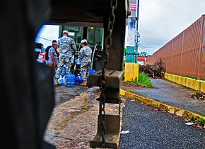
Puerto Rico National Guard with water trucks
-
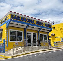
Barahona Auto Parts
-
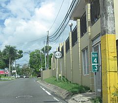
Puerto Rico Highway 633
.jpg)


See also
 In Spanish: Barahona (Morovis) para niños
- List of communities in Puerto Rico
