Barclay, Maryland facts for kids
Quick facts for kids
Barclay, Maryland
|
|||
|---|---|---|---|
|
|||

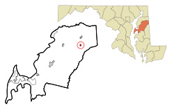
Location of Barclay, Maryland
|
|||
| Country | |||
| State | |||
| County | Queen Anne's | ||
| Incorporated | 1931 | ||
| Area | |||
| • Total | 0.40 sq mi (1.02 km2) | ||
| • Land | 0.40 sq mi (1.02 km2) | ||
| • Water | 0.00 sq mi (0.00 km2) | ||
| Elevation | 69 ft (21 m) | ||
| Population
(2020)
|
|||
| • Total | 183 | ||
| • Density | 462.12/sq mi (178.57/km2) | ||
| Time zone | UTC-5 (Eastern (EST)) | ||
| • Summer (DST) | UTC-4 (EDT) | ||
| ZIP code |
21607
|
||
| Area code(s) | 410 | ||
| FIPS code | 24-04250 | ||
| GNIS feature ID | 0597048 | ||
| Website | Official Website: https://www.barclaymaryland.com/ | ||
Barclay is a small town located in Queen Anne's County, Maryland, in the United States. It's a quiet place where people live. According to the 2020 census, 183 people called Barclay home.
Contents
Where is Barclay Located?
Barclay is found in the state of Maryland, in the Queen Anne's County. Its exact location is 39°8′41″N 75°51′53″W / 39.14472°N 75.86472°W.
The town is quite small. It covers an area of about 1.02 square kilometers (0.40 square miles). All of this area is land, meaning there are no large lakes or rivers within the town limits.
A Brief History of Barclay
Barclay has an interesting past. It was first started in 1873. Back then, it had a different name: Merrikton.
Later, in 1890, the community decided to change its name to Barclay. It officially became known as the "Town of Barclay" in February 1931. This means it became a recognized town with its own local government.
Getting Around Barclay
The main way to travel to and from Barclay is by road. Two important roads serve the town.
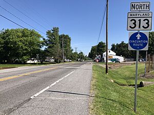
- Maryland Route 313 runs north and south through Barclay.
- Maryland Route 302 goes east and west.
Both of these roads connect to U.S. Route 301. This larger highway makes it easier to reach bigger cities nearby. For example, you can get to Philadelphia or Washington D.C. using this route.
Who Lives in Barclay?
The number of people living in Barclay has changed over the years. Here's a quick look at the population counts from different years:
| Historical population | |||
|---|---|---|---|
| Census | Pop. | %± | |
| 1940 | 119 | — | |
| 1950 | 108 | −9.2% | |
| 1960 | 142 | 31.5% | |
| 1970 | 187 | 31.7% | |
| 1980 | 132 | −29.4% | |
| 1990 | 170 | 28.8% | |
| 2000 | 143 | −15.9% | |
| 2010 | 120 | −16.1% | |
| 2020 | 183 | 52.5% | |
| U.S. Decennial Census | |||
Barclay's Population in 2010
In 2010, there were 120 people living in Barclay. These people lived in 48 different homes, and 32 of those were families.
Most of the people living in Barclay were White (88.3%). A small number were African American (0.8%) or Native American (4.2%). Some people (6.7%) were from other racial backgrounds. About 9.2% of the population identified as Hispanic or Latino.
The average age of people in Barclay in 2010 was about 42.5 years old.
- 20% of residents were under 18.
- About 9.2% were between 18 and 24.
- 24.2% were between 25 and 44.
- 39.1% were between 45 and 64.
- 7.5% were 65 years old or older.
There were slightly more females (53.3%) than males (46.7%) living in the town.
Famous People from Barclay
One notable person born in Barclay was William J. Winchester. He was a politician. He was born around 1876. When he was about 12 years old, in 1888, he moved away from Barclay to Wilmington, Delaware.
See also
 In Spanish: Barclay (Maryland) para niños
 | Kyle Baker |
 | Joseph Yoakum |
 | Laura Wheeler Waring |
 | Henry Ossawa Tanner |


