Barima River facts for kids
Quick facts for kids Barima River |
|
|---|---|

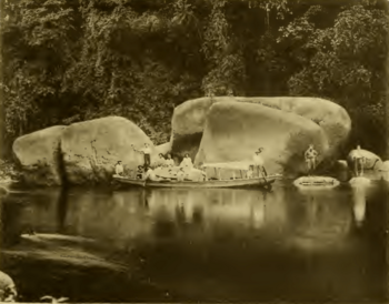
Arawatta Rock in the Barima River
|
|
|
Location of mouth
|
|
| Country | Guyana, Venezuela |
| Physical characteristics | |
| River mouth | 8°35′N 60°25′W / 8.583°N 60.417°W |
The Barima River is an important river in South America. It flows through two countries: Guyana and Venezuela. The Barima River is a tributary of the Orinoco River. This means it's a smaller river that flows into the larger Orinoco River. It joins the Orinoco River about 6.4 kilometers (4 miles) from the Atlantic Ocean.
Contents
Where Does the Barima River Start?
The Barima River begins in the Imataka Mountains in Guyana. These mountains are quite high! The river starts in a steep gorge, which is like a deep valley with rocky sides. This starting point is about 290 meters (950 feet) above sea level.
The river then flows for about 338 kilometers (210 miles). After this long journey, it enters Venezuela. It flows for another 80 kilometers (50 miles) or so before reaching its mouth. The mouth is where the river empties into a larger body of water, in this case, the Orinoco River.
What's Special About the Barima River?
One of the first people to explore and map parts of the Barima River was a person named Robert Hermann Schomburgk. He helped us learn more about this river and its path.
Along the river, near a place called Duquari Creek, you can find a very interesting landmark. It's called the Arawatta Rock. This is a large, unique granite rock that stands out in the landscape.
Towns Along the River
Several communities are located along the Barima River. These towns are part of the Barima-Waini Region in Guyana. Some of the main settlements include:
These communities often rely on the river for travel and trade.
See also

- Corocoro Island
- Río Barima para niños (In Spanish)
 | Sharif Bey |
 | Hale Woodruff |
 | Richmond Barthé |
 | Purvis Young |


