Barnard, Missouri facts for kids
Quick facts for kids
Barnard, Missouri
|
|
|---|---|

Location of Barnard, Missouri
|
|
| Country | United States |
| State | Missouri |
| County | Nodaway |
| Township | Grant |
| Area | |
| • Total | 0.15 sq mi (0.39 km2) |
| • Land | 0.15 sq mi (0.39 km2) |
| • Water | 0.00 sq mi (0.00 km2) |
| Elevation | 991 ft (302 m) |
| Population
(2020)
|
|
| • Total | 201 |
| • Density | 1,331.13/sq mi (513.01/km2) |
| Time zone | UTC-6 (Central (CST)) |
| • Summer (DST) | UTC-5 (CDT) |
| ZIP code |
64423
|
| Area code(s) | 660 |
| FIPS code | 29-03340 |
| GNIS feature ID | 2394061 |
Barnard is a city in southern Nodaway County, Missouri, United States. In 2020, about 201 people lived there. It is a small community with an interesting past.
Contents
History of Barnard
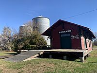
Barnard was officially created on April 10, 1870. A "plat" means the town's layout, like its streets and lots, was drawn up. The city was named after a railroad superintendent named Barnard. People are not completely sure if his name was J. F. Barnard or B. F. Barnard.
At first, the post office was in a nearby place called Prairie Park. But in 1871, it moved to Barnard. This helped the new city grow.
Geography of Barnard
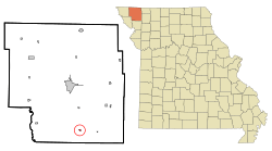
Barnard is located in the southern part of Nodaway County. It sits on the east side of the One Hundred and Two River. The city is found where two Missouri roads, Route M and Route WW, meet.
It is about 2.5 miles east of US Route 71. Other nearby towns include Guilford, which is 4.5 miles east, and Bolckow, about four miles south.
According to the United States Census Bureau, Barnard covers a total area of about 0.15 square miles (0.39 square kilometers). All of this area is land.
Population of Barnard
Barnard's population has changed over the years. Here is a look at how many people have lived in the city during different census counts:
| Historical population | |||
|---|---|---|---|
| Census | Pop. | %± | |
| 1880 | 424 | — | |
| 1890 | 427 | 0.7% | |
| 1900 | 362 | −15.2% | |
| 1910 | 338 | −6.6% | |
| 1920 | 345 | 2.1% | |
| 1930 | 325 | −5.8% | |
| 1940 | 341 | 4.9% | |
| 1950 | 275 | −19.4% | |
| 1960 | 237 | −13.8% | |
| 1970 | 206 | −13.1% | |
| 1980 | 234 | 13.6% | |
| 1990 | 234 | 0.0% | |
| 2000 | 257 | 9.8% | |
| 2010 | 221 | −14.0% | |
| 2020 | 201 | −9.0% | |
| U.S. Decennial Census | |||
Barnard in 2010
In 2010, there were 221 people living in Barnard. These people lived in 93 households. About 59 of these households were families.
The city had 107 housing units in total. The average household had about 2.38 people. The average family had about 3.08 people.
The average age of people in Barnard was 39.9 years. About 24.9% of the people were under 18 years old. Also, 20.4% of the people were 65 years or older.
Education in Barnard
Barnard is home to the South Nodaway R-IV School District. This district was recently combined into one school. Before 2013, the elementary school (Pre-K through 6th grade) was in Guilford. Guilford is about five miles east of Barnard.
To save money on keeping up the old elementary school, the district decided to bring all students together. They expanded the existing high school building in Barnard. Now, all students from Pre-K through high school attend classes in one building in Barnard.
See also
 In Spanish: Barnard (Misuri) para niños


