
Barnesville, Maryland facts for kids
Quick facts for kids
Barnesville, Maryland
|
||
|---|---|---|
|
||

Location of Barnesville, Maryland
|
||
| Country | ||
| State | ||
| County | Montgomery | |
| Incorporated | 1888 | |
| Area | ||
| • Total | 0.49 sq mi (1.27 km2) | |
| • Land | 0.49 sq mi (1.27 km2) | |
| • Water | 0.00 sq mi (0.00 km2) | |
| Elevation | 538 ft (164 m) | |
| Population
(2020)
|
||
| • Total | 144 | |
| • Density | 294.48/sq mi (113.71/km2) | |
| Time zone | UTC-5 (Eastern (EST)) | |
| • Summer (DST) | UTC-4 (EDT) | |
| ZIP code |
20838
|
|
| Area codes | 301, 240 | |
| FIPS code | 24-04475 | |
| GNIS feature ID | 2390713 | |

Barnesville is a small town located in Montgomery County, Maryland, in the United States. It officially became a town in 1888. According to the 2020 census, about 144 people live there.
Contents
History of Barnesville

The town of Barnesville was officially created in 1811 by the Maryland government. It was named after Williams Barnes, who was one of the first people to settle there. In its early days, Barnesville was a busy place for businesses and factories. It had two taverns, a blacksmith shop, and even a doctor named Dr. Lisle.
In the 1830s, a school called Barnesville Academy was open on the Hays Farm. It was led by Thomas Carr Lannan, an immigrant from Ireland. The first church services in Barnesville were held by Jesuit priests from Frederick. They helped build St. Mary's Church in 1807. The churchyard has graves of workers who died while building the Chesapeake & Ohio Canal. Barnesville Baptist Church started in 1871 and still uses its original wooden building today.
Geography and Climate
Town Area and Location
Barnesville covers a total area of about 0.49 square miles (1.27 square kilometers). All of this area is land. The town is located in a beautiful spot with views of nearby mountains.
Weather Patterns
The weather in Barnesville usually has hot and humid summers. The winters are generally mild to cool. This type of weather is known as a humid subtropical climate.
Population Information
| Historical population | |||
|---|---|---|---|
| Census | Pop. | %± | |
| 1910 | 154 | — | |
| 1920 | 149 | −3.2% | |
| 1930 | 110 | −26.2% | |
| 1940 | 121 | 10.0% | |
| 1950 | 130 | 7.4% | |
| 1960 | 145 | 11.5% | |
| 1970 | 162 | 11.7% | |
| 1980 | 141 | −13.0% | |
| 1990 | 170 | 20.6% | |
| 2000 | 161 | −5.3% | |
| 2010 | 172 | 6.8% | |
| 2020 | 144 | −16.3% | |
| U.S. Decennial Census | |||
Population in 2010
In 2010, there were 172 people living in Barnesville. These people lived in 67 homes, and 55 of those were families. The town had about 351 people per square mile.
Most of the people living in Barnesville were White (91.3%). About 25.6% of the residents were under 18 years old. The average age in the town was 48 years.
Community Life in Barnesville
Barnesville is located on top of a ridge. From here, you can see Sugarloaf Mountain to the north. To the west, you can see the Catoctin Mountain and Blue Ridge mountain ranges. This means residents can enjoy nature while still being able to travel to Washington, D.C. for work or other activities.
The town's motto is "A Caring Community." This shows how much the people who live in Barnesville care about their town and their neighbors. Barnesville is part of the Agricultural Reserve in Western Montgomery County.
The town has a train station for the MARC commuter rail system. This station helps people travel to and from Barnesville. The building itself was moved to Barnesville in 1977 from Rockville.
Education in Barnesville
Students in Barnesville attend schools run by the Montgomery County Public Schools.
Here are some of the schools that serve the Barnesville area:
- Barnesville School of Arts & Sciences: This is a private school for children from age three up to eighth grade.
- Monocacy Elementary School
- John Poole Middle School
- Poolesville High School
_at_Barnesville_Road_in_Barnesville,_Montgomery_County,_Maryland.jpg)
Transportation Routes
The main state highway that goes through Barnesville is Maryland Route 109. This road runs from northeast to southwest, but signs show it as going north and south. Northeast of Barnesville, MD 109 connects with Interstate 270 and Maryland Route 355 in Hyattstown. Southwest of Barnesville, MD 109 meets Maryland Route 28 on its way to Poolesville.
Famous People from Barnesville
Some notable people have connections to Barnesville:
- Laurence A. Abercrombie: A United States Navy admiral.
- Virginia Hall: An agent for the OSS during World War II.
Images for kids
-
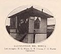
A railroad tower in Barnesville around 1914.
-
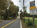
Maryland Route 109 leaving Barnesville.
See also
 In Spanish: Barnesville (Maryland) para niños
