
Barnet Urban District facts for kids
| Barnet | |
 Shield above the door of the former Council Offices on Wood Street, now the North London Coroner's Court |
|
| Geography | |
| 1911 area | 1,510 acres (6.1 km2) |
| 1931 area | 3,114 acres (12.6 km2) |
| 1961 area | 4,290 acres (17.4 km2) |
| HQ | 29 Wood Street, Barnet |
| History | |
| Created | 25 September 1863 |
| Abolished | 31 March 1965 |
| Succeeded by | London Borough of Barnet |
Quick facts for kids Demography |
|
|---|---|
| 1911 population - 1911 density |
10,440 6.9/acre |
| 1931 population - 1931 density |
14,726 4.7/acre |
| 1961 population - 1961 density |
27,846 6.5/acre |
| Politics | |
| Governance | Barnet Local Board (1863-1894) Barnet Urban District Council (1894-1965) |
Barnet was a special local area in south Hertfordshire, England. It had its own local government from 1863 to 1965. This area was centered around the town of Barnet.
Contents
How Barnet's Local Government Started
Barnet's local government district officially began on 25 September 1863. This happened after people living in the town decided they wanted to manage their own local services. They used a law called the Local Government Act 1858 to do this.
At first, a group called a local board ran things. This board was in charge of important services like public health. Later, in 1894, another law, the Local Government Act 1894, changed Barnet into an urban district. This meant the local board was replaced by an elected group called the Barnet Urban District Council. Over the years, the Barnet urban district grew bigger in 1905, 1914, and 1935.
Understanding Barnet's Local Areas
When Barnet's local government started, it included parts of different areas called parishes. These were Chipping Barnet in Hertfordshire, and Monken Hadley and South Mimms in Middlesex.
In 1889, the county borders were changed. This made sure that the entire Barnet district was located within Hertfordshire. It ended up being a long, thin part of Hertfordshire that stuck out into Middlesex.
How Barnet's Parishes Changed
The Local Government Act of 1894 divided the urban district into three new local areas, or civil parishes:
- Chipping Barnet (this was the part of the old Chipping Barnet parish that was in Barnet Urban District)
- Hadley (from the part of Monken Hadley parish in Barnet Urban District)
- South Mimms Urban (from the part of South Mimms parish in Barnet Urban District)
Barnet continued to grow. In 1896, the South Mimms Urban parish became larger. In 1897, the Chipping Barnet parish also gained more land. Later, in 1905 and 1914, the parishes of Arkley and Totteridge were added to the Barnet district. Finally, in 1935, a new parish called Rowley was added. This parish was created from parts of Elstree, Ridge, and Shenley.
When Barnet's Local Government Ended
The Barnet Urban District stopped existing on 1 April 1965. This happened because of a new law called the London Government Act 1963. This law changed how London was governed.
Barnet's area was then moved from Hertfordshire to a much larger area called Greater London. The old Barnet district was combined with other nearby areas to create the London Borough of Barnet that we know today.
How Barnet Was Governed
For local elections, the Barnet urban district was split into six smaller areas called wards. These wards were: Arkley East, Arkley West, Barnet North, Barnet South, Totteridge East, and Totteridge West. People living in each ward would vote for their local representatives.
Choosing Representatives for Parliament
For elections to the national government, called Parliament, the Barnet urban district was part of a larger area called a constituency. At first, it was part of the Mid or St Albans Division of Hertfordshire constituency.
In 1945, the St Albans constituency became too big. So, it was divided into smaller parts. Barnet urban district then became part of a new constituency called Barnet. This meant people in Barnet voted for a Member of Parliament (MP) to represent them in the national Parliament.
Gallery
-
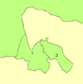
In 1961: 1 is Barnet and 2 is East Barnet
-
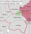
District in 1863.
-
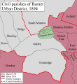
District in 1894.
-
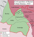
District in 1935.


