
East Barnet Urban District facts for kids
| East Barnet East Barnet Valley (1863–1935) |
|
| Motto: Willingness rids way | |
 |
|
| Geography | |
| Status | Local government district (1863–1875) Urban sanitary district (1875-1894) Urban district (1894–1965) |
| 1911 area | 2,644 acres (10.70 km2) |
| 1961 area | 2,644 acres (10.70 km2) |
| HQ | Station Road, New Barnet |
| History | |
| Created | 1863 |
| Abolished | 1965 |
| Succeeded by | London Borough of Barnet |
Quick facts for kids Demography |
|
|---|---|
| 1911 population | 12,381 |
| 1961 population | 40,641 |
| Politics | |
| Governance | East Barnet Valley Local Board (1863–1875) East Barnet Valley Urban Sanitary Authority (1875-1894) East Barnet Valley Urban District Council (1894–1935) East Barnet Urban District Council (1935–1965) |
 |
|
East Barnet Valley was a special local government area that existed from 1863 to 1965. It was located around the town of East Barnet. For a while, it was partly in Hertfordshire and partly in Middlesex. But in 1889, the Middlesex part was moved to Hertfordshire. In 1935, its name was changed to East Barnet.
Contents
How East Barnet Valley Started
This area was created on September 25, 1863. It was set up under a law from 1858 that helped manage local places. The area was called the East Barnet Valley Local Government District. It was run by a group called a local board. This board helped look after things like public health and services.
The district included the main area of East Barnet. It also took in parts of nearby places. These included Chipping Barnet in Hertfordshire. It also included parts of Enfield, Monken Hadley, and South Mimms in Middlesex.
Changes Over Time
Becoming an Urban District
In 1889, there was a big change to how local areas were set up. The part of East Barnet Valley that was in Middlesex officially became part of Hertfordshire. This meant the whole district was then in one county.
In 1894, the local board area became an urban district. This meant it had its own council, called the East Barnet Valley Urban District Council. This council was in charge of running the area.
The urban district was made up of three smaller areas called civil parishes. Here's how big they were in 1901:
- East Barnet (about 1,697 acres)
- Barnet Vale (this was the part that used to be in Chipping Barnet parish) (about 279 acres)
- Monken Hadley (these were the parts that used to be in Middlesex) (about 668 acres)
In 1935, the urban district changed its name again. It became simply East Barnet. This district had a unique shape. It was a long, thin area that poked into Middlesex. It was surrounded by Middlesex on three sides: north, east, and south.
East Barnet's Coat of Arms
A coat of arms is a special symbol or design. The East Barnet urban district council had its own unofficial coat of arms at first. It had a shield with two crossed swords. Between the swords were a red rose and a white rose. These roses were symbols of the Wars of the Roses. This was a series of battles in English history, and the Battle of Barnet was a very important one. The Greek letter omega was also on the shield.
The top part of the shield, called the chief, showed a fleur de lys. This is a lily symbol. It also had two flory crosses. These symbols were for St Mary, who was the patron saint of the old East Barnet parish.
In 1955, this design became an official coat of arms. A new part, called a crest, was added above the shield. This crest showed a hart, which is a type of deer. The hart came from the coat of arms of Hertfordshire County Council. A small shield hung from the hart's neck. This shield had the cross of St Alban on it. This cross showed the historical links to the Abbey of St Albans.
The motto chosen for the coat of arms was Willingness Rids Way. This motto came from a play by William Shakespeare called Henry VI, Part 3. It was spoken by King Edward IV after the Battle of Barnet.
When East Barnet District Ended
In 1965, the East Barnet urban district was officially closed down. This happened because of a new law called the London Government Act 1963. Its area was then moved from Hertfordshire to Greater London. The area of East Barnet was combined with other nearby districts. Together, they formed the new London Borough of Barnet that we know today.
Population Growth
The East Barnet urban district covered about 2,644 acres (about 10.7 square kilometers). The number of people living there grew a lot over the years. Here's how the population changed according to official counts:
| Year | 1901 | 1911 | 1921 | 1931 | 1941 | 1951 | 1961 |
|---|---|---|---|---|---|---|---|
| Population | 10,094 | 12,381 | 13,514 | 18,549 | 40,408 | 40,641 |
How East Barnet Was Governed
Local Elections
The urban district was divided into seven areas for elections. These areas were called wards. They included Brunswick Park, Cockfosters, East Barnet, Hadley, Lyonsdown, New Barnet, and Osidge. People in these wards would vote for their local council members.
Parliamentary Elections
For elections to the UK Parliament, the urban district was part of a larger area called a constituency. It was first part of the Mid or St Albans Division of Hertfordshire constituency.
In 1945, the St Albans constituency became too big. So, it was split into two. The East Barnet urban district then became part of a new constituency called Barnet.
Images for kids
-
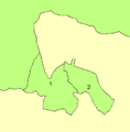
In 1961: 1 is Barnet and 2 is East Barnet
-
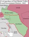
District in 1863.
-
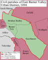
District in 1894.
-
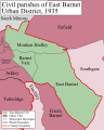
District in 1935.


