Elstree and Borehamwood facts for kids
Quick facts for kids Elstree and Borehamwood |
|
|---|---|
| Area | 5.315 sq mi (13.77 km2) |
| Population | 41,423 (2021) |
| • Density | 7,794/sq mi (3,009/km2) |
| OS grid reference | TQ195975 |
| • London | 12 mi (19 km) SE |
| Civil parish |
|
| District |
|
| Shire county | |
| Region | |
| Country | England |
| Sovereign state | United Kingdom |
| Post town | BOREHAMWOOD |
| Postcode district | WD6 |
| Dialling code | 020 |
| Police | Hertfordshire |
| Fire | Hertfordshire |
| Ambulance | East of England |
| EU Parliament | East of England |
| UK Parliament |
|
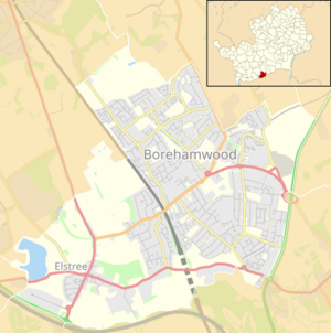
Elstree and Borehamwood is a town in Hertfordshire, England. It's about 12 miles (19 km) northwest of central London, right next to the edge of Greater London. This area has many homes, some open green spaces, and a bit of light industry. It used to be called just Elstree, but now it includes both Elstree and Borehamwood. A local group called the Elstree and Borehamwood Town Council helps run the area. In 2021, about 41,423 people lived here, making it one of the most populated local areas in England.
Contents
History of Elstree and Borehamwood
Early Beginnings
Elstree was once a very old local area called an "ancient parish" in Hertfordshire. In 1894, it became part of the Barnet Rural District. This is when the Elstree Parish Council was first created to help manage the local area.
Changes Over Time
The Barnet Rural District changed its name to Elstree Rural District in 1941. Later, in 1974, Elstree became part of the Borough of Hertsmere.
A law passed in 1972 allowed local councils to change their names. So, on February 24, 1982, the name of the area officially changed to Elstree and Borehamwood. The local council also became the Elstree and Borehamwood Town Council.
Boundary Adjustments
On April 1, 1993, the borders of Elstree and Borehamwood were slightly changed. A small part of Elstree village that was in Greater London moved into Hertfordshire. This meant some areas that were in the boroughs of Barnet and Harrow became part of Hertfordshire.
Geography of the Area
Size and Location
The area of Elstree and Borehamwood is about 5.315 square miles (13.77 square kilometers). It is located roughly 12 miles (19 km) northwest of central London. The southern and eastern parts of the area are right next to the Greater London boundary.
What the Area Looks Like
This area mostly has homes where people live. There are also some light industries and open green spaces. These green areas are part of the Metropolitan Green Belt, which helps protect nature around London.
The area includes two main settlements: Elstree and Borehamwood. These two parts are separated by the Midland Main Line railway track. For mail, most of the area uses the Borehamwood post town and the WD6 postcode district. Phone numbers in Elstree use the 020 code, which is the same as London numbers.
Getting Around: Transport
Train Services
Elstree & Borehamwood railway station is located between the two main parts of the town. It's on the Thameslink train line, which connects places like Bedford to Brighton through Central London. Even though it's outside Greater London, this station is in London's fare zone 6. This means you can use Travelcard and Oyster card for your train journeys here.
Bus Connections
The area is also served by London Buses routes. These include routes 107 and 292. These bus routes help people travel to nearby places like Arkley, Chipping Barnet, Colindale, Edgware, and New Barnet.
See also
 In Spanish: Elstree and Borehamwood para niños
 | William L. Dawson |
 | W. E. B. Du Bois |
 | Harry Belafonte |


