Bartolo, Lares, Puerto Rico facts for kids
Quick facts for kids
Bartolo
|
|
|---|---|
|
Barrio
|
|

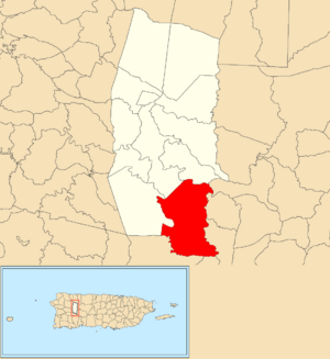
Location of Bartolo barrio within the municipality of Lares shown in red
|
|
| Lua error in Module:Location_map at line 416: Malformed coordinates value. | |
| Commonwealth | |
| Municipality | |
| Area | |
| • Total | 8.44 sq mi (21.9 km2) |
| • Land | 8.25 sq mi (21.4 km2) |
| • Water | 0.19 sq mi (0.5 km2) |
| Elevation | 1,818 ft (554 m) |
| Population
(2010)
|
|
| • Total | 2,035 |
| • Density | 246.7/sq mi (95.3/km2) |
| Source: 2010 Census | |
| Time zone | UTC−4 (AST) |
Bartolo is a special kind of neighborhood called a barrio in Lares, Puerto Rico. In 2010, about 2,035 people lived there. Bartolo is located on the southeastern edge of Lares, right next to another town called Adjuntas.
Contents
History of Bartolo
After the Spanish–American War, Spain gave Puerto Rico to the United States. This happened because of a peace agreement called the Treaty of Paris of 1898. Puerto Rico then became a territory of the United States.
In 1899, the United States government took a count of all the people in Puerto Rico. This count, called a census, showed that 2,035 people lived in the Bartolo barrio at that time.
| Historical population | |||
|---|---|---|---|
| Census | Pop. | %± | |
| 1900 | 2,035 | — | |
| 1910 | 1,991 | −2.2% | |
| 1920 | 2,117 | 6.3% | |
| 1930 | 2,409 | 13.8% | |
| 1940 | 2,464 | 2.3% | |
| 1950 | 2,951 | 19.8% | |
| 1980 | 2,483 | — | |
| 1990 | 2,311 | −6.9% | |
| 2000 | 2,030 | −12.2% | |
| 2010 | 2,035 | 0.2% | |
| U.S. Decennial Census 1899 (shown as 1900) 1910-1930 1930-1950 1980-2000 2010 |
|||
What are Sectors?
Barrios are like big neighborhoods. They are often divided into smaller areas called sectores, which means sectors in English. These sectors can have different names, like urbanización or reparto.
Sectors in Bartolo
Here are some of the smaller areas, or sectores, that make up Bartolo:
- Calle Cirila
- Calle Cooperativismo
- Calle Los Millonarios
- Calle Paraíso
- Carretera Los Romero
- Carretera Vilella
- Cerro Las Avispas
- Condominio Alturas de Castañer
- Poblado Castañer
- Sector Calbache
- Sector Grillasca
- Sector Guano
- Sector La Cuesta
- Sector Rábanos
- Sector Regino
- Sector San Juan Bautista
- Tramo Carretera 128
- Tramo Carretera 135
- Tramo Carretera 431
Jíbaros Mutual Support Center
There was an old school in Bartolo called Manuel Rojas Luzardo. It was built in 1922 but closed down in 2015.
In September 2017, a very strong storm called Hurricane Maria hit Puerto Rico. Many homes were destroyed, and people were left without a place to live.
A group of local farmers, known as jíbaros, decided to help. They worked together to fix up the old, abandoned school. They got help from businesses, including a donation of solar panels for electricity.
Now, the old school is called the Jíbaros Mutual Support Center (Spanish: Centro de Apoyo Mutuo Jíbaro). It's a place where people can find help and support. The classrooms have become homes for eleven families, especially those led by women and elderly people.
The center also has small businesses, like a theater. Members of the local Presbyterian church helped start this community effort. They are now working to officially own the school property. Similar support centers have also started in other parts of Puerto Rico.
See also
 In Spanish: Bartolo (Lares) para niños
- List of communities in Puerto Rico
- List of barrios and sectors of Lares, Puerto Rico
 | DeHart Hubbard |
 | Wilma Rudolph |
 | Jesse Owens |
 | Jackie Joyner-Kersee |
 | Major Taylor |

