Bathgate, North Dakota facts for kids
Quick facts for kids
Bathgate
|
|
|---|---|

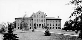
North Dakota School for the Blind in 1908
|
|

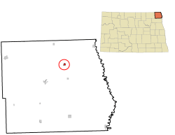
Location of Bathgate, North Dakota
|
|
| Country | United States |
| State | North Dakota |
| County | Pembina |
| Founded | 1881 |
| Area | |
| • Total | 0.28 sq mi (0.72 km2) |
| • Land | 0.28 sq mi (0.72 km2) |
| • Water | 0.00 sq mi (0.00 km2) |
| Elevation | 820 ft (250 m) |
| Population
(2020)
|
|
| • Total | 47 |
| • Estimate
(2022)
|
48 |
| • Density | 169.68/sq mi (65.50/km2) |
| Time zone | UTC–6 (Central (CST)) |
| • Summer (DST) | UTC–5 (CDT) |
| ZIP Code |
58216
|
| Area code(s) | 701 |
| FIPS code | 38-05260 |
| GNIS feature ID | 1035924 |
Bathgate is a small city in Pembina County, North Dakota, United States. It is located right next to the Tongue River. In 2020, the city had a population of 47 people.
Bathgate was started in 1881. A special school called the North Dakota School for the Blind was built here in 1908. This building is still standing today and is used by a company that publishes books. A famous speed skater and figure skater named Norval Baptie grew up in Bathgate.
Contents
Discover Bathgate's Past
Bathgate was first called Bayview when it was planned in 1879. The city changed its name to Bathgate in 1881. This new name came from a town in Bathgate, Scotland. A post office opened in Bathgate the same year.
In June 1909, a very strong thunderstorm hit Bathgate. It lasted for 11 hours and caused damage to several buildings.
Where is Bathgate Located?
Bathgate is a small town in North Dakota. The United States Census Bureau says the city covers about 0.72 square kilometers (0.28 square miles) of land. There is no water area within the city limits.
Who Lives in Bathgate?
| Historical population | |||
|---|---|---|---|
| Census | Pop. | %± | |
| 1890 | 377 | — | |
| 1900 | 641 | 70.0% | |
| 1910 | 328 | −48.8% | |
| 1920 | 352 | 7.3% | |
| 1930 | 292 | −17.0% | |
| 1940 | 312 | 6.8% | |
| 1950 | 209 | −33.0% | |
| 1960 | 175 | −16.3% | |
| 1970 | 133 | −24.0% | |
| 1980 | 67 | −49.6% | |
| 1990 | 75 | 11.9% | |
| 2000 | 66 | −12.0% | |
| 2010 | 43 | −34.8% | |
| 2020 | 47 | 9.3% | |
| 2022 (est.) | 48 | 11.6% | |
| U.S. Decennial Census 2020 Census |
|||
Population in 2010
In 2010, there were 43 people living in Bathgate. These people lived in 22 different homes. About half of these homes (11) were families.
Most people living in Bathgate were White (95.3%). A small number were Native American (4.7%). About 2.3% of the people were Hispanic or Latino.
The average age of people in Bathgate was about 49.5 years old.
- 18.6% of residents were under 18 years old.
- 2.4% were between 18 and 24 years old.
- 23.3% were between 25 and 44 years old.
- 37.2% were between 45 and 64 years old.
- 18.6% were 65 years or older.
The population was almost evenly split between males (51.2%) and females (48.8%).
See also
 In Spanish: Bathgate (Dakota del Norte) para niños
 | Roy Wilkins |
 | John Lewis |
 | Linda Carol Brown |

