Bayet facts for kids
Quick facts for kids
Bayet
|
|
|---|---|
|
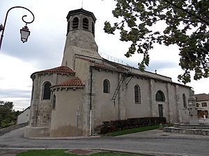
The Church of Saint Marcel
|
|
| Country | France |
| Region | Auvergne-Rhône-Alpes |
| Department | Allier |
| Arrondissement | Moulins |
| Canton | Saint-Pourçain-sur-Sioule |
| Intercommunality | Pays Saint-Pourcinois |
| Area
1
|
22.58 km2 (8.72 sq mi) |
| Time zone | UTC+01:00 (CET) |
| • Summer (DST) | UTC+02:00 (CEST) |
| INSEE/Postal code |
03018 /03500
|
| Elevation | 237–290 m (778–951 ft) (avg. 235 m or 771 ft) |
| 1 French Land Register data, which excludes lakes, ponds, glaciers > 1 km2 (0.386 sq mi or 247 acres) and river estuaries. | |
Bayet is a small town, known as a commune, located in central France. It's part of the Allier department, which is like a county, within the Auvergne-Rhône-Alpes region. People who live in Bayet are called Bayétois (for boys and men) or Bayétoises (for girls and women).
Exploring Bayet's Location
Bayet is found about 36 kilometers (about 22 miles) south of a city called Moulins. It's also around 18 kilometers (about 11 miles) north-west of Vichy. You can reach Bayet by main roads that connect it to nearby towns. The area around Bayet is mostly farmland.
Rivers and Waterways
Two important rivers flow through the Bayet area. The Sioule river travels from the south to the north through the commune. It eventually joins the Allier river further north. The Bouble river also flows through the western part of Bayet. It moves towards the north-east until it meets the Sioule river right on the edge of the commune.
Old Railway Line
A railway line used to run through Bayet. It was built a long time ago, in 1932, and was one of the last lines opened by a big French railway company. However, it didn't carry passengers for very long, stopping in 1938. Later, in 1960, it was closed for freight (goods) trains too. The tracks were removed, and by 1974, part of the old railway path was turned into a walking trail.
 | Laphonza Butler |
 | Daisy Bates |
 | Elizabeth Piper Ensley |


