Beach Lighthouse (Fleetwood) facts for kids
 |
|
| The Beach Lighthouse, Fleetwood | |
|
|
|
| Location | Fleetwood Lancashire England United Kingdom |
|---|---|
| Coordinates | 53°55′43″N 3°00′32″W / 53.928554°N 3.009025°W |
| Year first constructed | 1840 |
| Construction | sandstone tower |
| Tower shape | square tower with octagonal lantern rising from a colonnaded 1-storey building |
| Height | 13 metres (43 ft) |
| Focal height | 14 metres (46 ft) |
| Range | 6 nautical miles (11 km) |
| Characteristic | Fl G 2s. light aligns with Upper Light guides shipping down Wyre Channel |
| Admiralty number | A4892 |
| NGA number | 5152 |
| ARLHS number | ENG-195 |
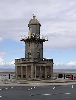
The Beach Lighthouse, also known as the Lower Light, is a tall lighthouse in Fleetwood, Lancashire, England. It stands about 13 meters (44 feet) high and is made of sandstone. This important building helps guide ships safely into the Wyre estuary.
Contents
History of the Lighthouse
Who Designed This Lighthouse?
This lighthouse was designed in 1839 by Decimus Burton and Captain H.M. Denham. Decimus Burton also helped plan the new town of Fleetwood. The Beach Lighthouse looks special because it has a classic, elegant style. It features a square base with columns, a square tower, and an eight-sided top part.
How the Lights Guide Ships
The Lower Light stands on the Fleetwood seafront. It was built with another lighthouse, the Upper Light, also known as the Pharos Lighthouse. Together, these two lights create a special line that guides ships. When the Pharos Light appears directly above the Lower Light, ships know they are on the correct path.
These two lighthouses can guide ships from about 12 nautical miles (22 kilometers) away. They also point towards the Wyre Light, which is about 2 nautical miles (4 kilometers) offshore on the North Wharf Bank.
When the Lights First Shone
Both the Beach Lighthouse and the Pharos Lighthouse first lit up on December 1, 1840. They originally ran on the town's gas supply. Each lighthouse had a single special mirror, called a parabolic reflector, behind its light. This mirror helped to make the light brighter and more focused. Later, both lighthouses were changed to run on electricity.
A Protected Landmark
The Beach Lighthouse is a very important historical building. On April 26, 1950, it was officially named a Grade II listed building by English Heritage. This means it is protected because of its special history and architecture. The Port of Fleetwood now manages the lighthouse, making sure it continues to serve its purpose.
 | Dorothy Vaughan |
 | Charles Henry Turner |
 | Hildrus Poindexter |
 | Henry Cecil McBay |


