Bear Creek Greenway facts for kids
Quick facts for kids Bear Creek Greenway |
|
|---|---|

|
|
| Length | 17.9 mi (28.8 km) |
| Location | Jackson County, Oregon |
| Trailheads | Ashland, Central Point |
| Use | Cycling, Hiking |
| Elevation change | 482 ft (147 m) |
| Highest point | Ashland Dog Park trailhead |
| Lowest point | Peninger Road trailhead |
| Difficulty | Easy |
| Season | Year-round |
| Hazards | Sharp turns, blind corners, occasional root bumps and other rough surfaces; auto traffic at street crossing |
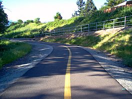
The Bear Creek Greenway is a fantastic path for biking and hiking in Oregon, USA. It's about 17.9 miles (28.8 km) long! This path stretches from Ashland all the way to Central Point. As you travel, it goes through towns like Talent, Phoenix, and Medford. The path mostly follows along Bear Creek, which is a smaller river flowing into the Rogue River.
The Greenway has two lanes, one for each direction of travel. This helps keep everyone safe. No cars or other motor vehicles are allowed on the path, except for county workers doing maintenance. It's a great place for outdoor fun!
Contents
How the Bear Creek Greenway Started
People might have talked about a bike path in the Medford area as early as 1899. Bicycles were becoming very popular back then. Jackson County even collected $500 from a bike tax that year. This money was meant for building a path, but the project didn't happen.
Many years later, in 1973, a person named Al Densmore helped get things moving. He was a representative, which means he was elected to speak for people in the government. He presented a bill, which is a proposed law, to the Oregon Legislative Assembly. This bill allowed the Oregon Department of Transportation to build about 3.4 miles (5.5 km) of the greenway that same year.
Building the Path Over Time
Getting money for the Bear Creek Greenway happened in small steps. Because of this, building the path took place bit by bit over 40 years. Even before the big Interstate 5 highway was built, people wanted a "Greenway Movement." They hoped for a chain of parks connected by a trail from Ashland to Rogue River.
When Al Densmore's bill passed, Jackson County started buying land for the path. Sections of the greenway were finished in 1973, 1980, 1995, and 1998.
By 2011, the Bear Creek Greenway was finally complete from Ashland to Central Point. Most of the time, when the path crosses a road, it goes over or under it. There's only one spot near Talent, at Suncrest Road, where you need to cross the street directly.
Future Plans for the Greenway
The Bear Creek Greenway Foundation is working to raise money for a new section. This part would add about 1.4 miles (2.3 km) between Pine Street and Upton Road in Central Point.
There are also plans for the Bear Creek Greenway to connect to another path called the Rogue River Greenway. This future path would go along the Rogue River from Central Point to Grants Pass. If both paths are finished, you could bike or hike all the way from Ashland to Grants Pass! Most of this long path would be safe from car traffic. Also, some parts of the trail are being improved to prevent damage from different soil types during the year.
Places Along the Greenway
The Bear Creek Greenway passes through several towns and has different access points. Here are some of the key locations along the path:
| Location | Coordinates | Trail location | Elevation | ||
|---|---|---|---|---|---|
| Ashland Dog Park trailhead | 42°12′40.15″N 122°42′43.75″W / 42.2111528°N 122.7121528°W | 0.0 | 0 | 1,747 | 532 |
| South Valley View Road | 42°13′16.55″N 122°44′25.43″W / 42.2212639°N 122.7403972°W | 2.0 | 3.2 | 1,650 | 500 |
| West Valley View Road | 42°14′43.87″N 122°46′33.77″W / 42.2455194°N 122.7760472°W | 4.75 | 7.64 | 1,567 | 478 |
| Fern Valley Road | 42°16′48.87″N 122°49′10.57″W / 42.2802417°N 122.8196028°W | 8.3 | 13.4 | 1,465 | 447 |
| Barnett Road | 42°18′56.39″N 122°50′59.47″W / 42.3156639°N 122.8498528°W | 11.75 | 18.91 | 1,393 | 425 |
| Table Rock Road | 42°21′49.29″N 122°53′07.13″W / 42.3636917°N 122.8853139°W | 16.05 | 25.83 | 1,297 | 395 |
| Peninger Road trailhead (Central Point) | 42°22′46.48″N 122°54′02.32″W / 42.3795778°N 122.9006444°W | 17.7 | 28.5 | 1,265 | 386 |
 | Bessie Coleman |
 | Spann Watson |
 | Jill E. Brown |
 | Sherman W. White |

