
Bearcamp River facts for kids
Quick facts for kids Bearcamp River |
|
|---|---|

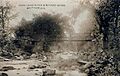
The Bearcamp River in South Tamworth, New Hampshire
|
|


|
|
| Country | United States |
| State | New Hampshire |
| County | Carroll |
| Towns | Sandwich, Tamworth, Ossipee |
| Physical characteristics | |
| Main source | Sandwich Notch Sandwich 1,420 ft (430 m) 43°50′13″N 71°30′44″W / 43.83694°N 71.51222°W |
| River mouth | Ossipee Lake Ossipee 407 ft (124 m) 43°47′51″N 71°9′27″W / 43.79750°N 71.15750°W |
| Length | 26.3 mi (42.3 km) |
| Basin features | |
| Tributaries |
|
The Bearcamp River is a river in New Hampshire, United States. It is about 26.3-mile-long (42.3 km). This river flows along the southern edge of the famous White Mountains.
The Bearcamp River is the biggest river that flows into Ossipee Lake. Ossipee Lake is part of the larger Saco River watershed. A watershed is an area of land where all the water drains into a common river or lake. In this case, the water from the Bearcamp River eventually makes its way to the Atlantic Ocean.
Contents
Where Does the Bearcamp River Start and End?
The River's Journey
The Bearcamp River begins in a place called Sandwich Notch. This area is located in the town of Sandwich, New Hampshire. It's nestled between the Squam Mountain Range and the Sandwich Range.
From its starting point, the river flows towards the southeast. Along its path, it tumbles over a beautiful spot known as Beede Falls. After the falls, the river quickly reaches the lower lands at the base of the White Mountains.
Flowing Through Towns
The river continues its journey eastward through Sandwich. It then enters the town of Tamworth. Here, another river called the Cold River joins it.
As it moves through Tamworth, the Bearcamp River passes by the villages of South Tamworth and Whittier. The river then gets closer to the Ossipee Mountains to its south.
Finally, the Bearcamp River flows past the village of West Ossipee. It then enters Ossipee Lake through a small river delta. A delta is a landform that is created when a river deposits its sediment as it flows into a larger body of water.
Traveling Along the River
If you're ever in the area, New Hampshire Route 25 follows the Bearcamp River. This road runs alongside the river as it goes through Tamworth all the way to West Ossipee. It's a great way to see parts of the river's path.
Images for kids
-
Bearcamp River in 1912

