Beartown Wilderness Addition A facts for kids
Quick facts for kids Beartown Wilderness Addition A |
|
|---|---|
| Location | Tazewell County Virginia, United States |
| Nearest town | Tazewell, Virginia |
| Area | 1,369 acres (5.54 km2) |
| Administrator | U.S. Forest Service |
Beartown Wilderness Addition A is a special wild area in western Virginia. It's part of the George Washington and Jefferson National Forests. A group called the Wilderness Society thinks this place is so important it should be protected. They want to keep it safe from logging and building new roads. They even call it a "Mountain Treasure"!
This area is right next to the Beartown Wilderness. It's a remote spot, meaning it's far from towns and busy places. The Forest Service says it has amazing views and tough, rocky land. This makes it a great challenge for people who enjoy finding their way with a map or camping deep in nature. This wild area is also part of the Garden Mountain Cluster.
Contents
Where is Beartown Wilderness Addition A?
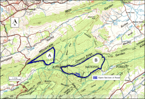
This wild area is found in the Appalachian Mountains of Southwest Virginia. It's located east of Route 16 and west of the main Beartown Wilderness. You can find it about six miles south of the town of Tazewell, Virginia.
There are no paved roads or even dirt roads for cars inside this area. But, there are some old trails and logging paths you can use. These paths are usually between three and five miles long. You can find old logging roads and railway lines by looking at historical maps from the United States Geological Survey (USGS). The USGS makes detailed maps of the land. The maps that cover this wild area are called Hutcheson Rock and Tazewell South.
The map next to this text shows the exact borders of this wild land. You can also find more trails and roads nearby on National Geographic Map 787. This map covers the Blacksburg and New River Valley areas. If you want to learn even more, you can click on the coordinates link at the top right of this page. It will show you maps, aerial views, satellite data, and even weather info for the area!
Nature and Wildlife
This area is part of a big forest region called the Central Appalachian Broadleaf Coniferous Forest-Meadow Province. It's a fancy name for a place with many different kinds of trees.
You'll find trees like yellow poplar, northern red oak, and white oak. There are also basswood, cucumber tree, white ash, and eastern hemlock. These trees grow in valleys, at the bottom of hills, and along small streams. On the north and west sides, you'll mostly see white oak, northern red oak, and hickory trees. On the tops of ridges and in open spots, you'll find chestnut oak, scarlet oak, and yellow pine.
About 285 acres of this area might be old growth forest. This means the trees are very old and have been growing for a long time without being cut down.
Most of the area is a "Dry Mesic Oak" type of forest. This means it's a bit dry but still has enough moisture for oak trees to thrive. The land here changes a lot, from hot, windy ridges to cool, damp valleys. This variety creates many different places for plants and animals to live.
Mountains and Rivers
This wild land is part of the Ridge-and-Valley Appalachians. This area is known for its long, parallel ridges and valleys. The ridges are made of sandstone and shale rock. The valleys are formed from limestone or shale.
The area is on the south side of Clinch Mountain. This is where the mountain ends and changes into a unique, dome-shaped area called Burkes Garden.
The lowest point in the area is 2320 feet high. You'll find this along the southern border. The highest point is 3800 feet high. This is at the top of Clinch Mountain in the north.
The area also includes the start of two creeks: Roaring Fork and Laurel Creek. Roaring Fork flows into Laurel Creek. Laurel Creek then empties into the North Fork Holston River. You can even canoe on Laurel Creek from where it flows near Route 601, close to Asberrys, Virginia.
How the Forest Service Manages the Area
The U.S. Forest Service looks at its lands to see which ones could become "wilderness areas." When an area is named a wilderness, it gets a very high level of protection. This means it's kept safe from development like logging or building roads.
Areas that are good for wilderness protection are called "inventoried roadless areas." Later, a "Roadless Rule" was put in place. This rule stopped new roads from being built in these special areas. It helped protect the environment by reducing the harm that road building can cause. This rule helps keep these roadless areas wild and natural. Beartown Wilderness Addition A was part of this review. Because of this, it is protected from new roads and from timber (tree) sales.
About 1246 acres of this land have private owners for the minerals under the ground. Even so, the surface land is still managed by the Forest Service.
The Forest Service also gives different parts of the forest a "recreational opportunity setting." This tells visitors what kind of activities they can do there. This area is called "Backcountry—Natural Process." This is the strongest level of protection for a backcountry area. It means the land is kept as natural as possible, with very little human impact.


